Stockwood, Dorset

Last updated

Stockwood
Stockwood Church.JPG
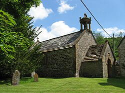
Church of St Edwold, Stockwood
Dorset UK location map.svg
Red pog.svg
Stockwood
Location within Dorset
Population27 (2001 census)
Civil parish
  • Stockwood
Unitary authority
Ceremonial county
Region
Country England
Sovereign state United Kingdom
List of places
UK
England
Dorset
50°51′42″N2°35′14″W / 50.86167°N 2.58722°W / 50.86167; -2.58722

Stockwood is a village and civil parish in west Dorset, England, around eight miles south-west of Sherborne and less than a mile away from Chetnole railway station on the Heart of Wessex Line. There are a few houses on the road leading to the A37 between Yeovil and Dorchester. In 2001 the parish had a population of 27.

St Edwold's Church, often described as Dorset's smallest church, is located in Stockwood. [1]

Related Research Articles

<span class="mw-page-title-main">East Stour, Dorset</span> Human settlement in England

East Stour is a village and civil parish in the ceremonial county of Dorset in southern England. It lies within the Dorset administrative district, about two miles south of the town of Gillingham. The village is 12 mile from the east bank of the River Stour in the Blackmore Vale and two miles west of the broadly conical local landmark Duncliffe Hill. Above the west bank of the river, about one mile away, is the village of West Stour. The A30 London to Penzance road passes through the village. In the 2011 census the civil parish had a population of 573.

<span class="mw-page-title-main">Kimmeridge</span> Human settlement in England

Kimmeridge is a small village and civil parish on the Isle of Purbeck, a peninsula on the English Channel coast in Dorset, England. It is situated about 4.5 miles (7.2 km) south of Wareham and 7 miles (11 km) west of Swanage. In 2013 the estimated population of the civil parish was 90.

<span class="mw-page-title-main">Abbotsbury</span> Village in Dorset, England

Abbotsbury is a village and civil parish in the English county of Dorset. The settlement is in the unitary authority of Dorset about 1 mile (1.6 km) inland from the English Channel coast. The village, including Chesil Beach, the swannery and subtropical gardens, is owned by the Ilchester Estate, which owns 61 square kilometres of land in Dorset. In the 2011 census the civil parish had a population of 481.

<span class="mw-page-title-main">Burton Bradstock</span> Human settlement in England

Burton Bradstock is a village and civil parish in Dorset, England, approximately 2+12 miles (4 km) southeast of Bridport and 12 mile (0.8 km) inland from the English Channel at Chesil Beach. In the 2011 Census the parish had a population of 948. The village lies in the Bride Valley, close to the mouth of the small River Bride. It comprises 16th- and 17th-century thatched cottages, a parish church, two pubs, a primary school, shop, post office stores, beach café, hotel, garage, village hall, reading room a library. The parish has a National Coastwatch Institution Station, Lyme Bay Station.

<span class="mw-page-title-main">Hilton, Dorset</span> Village in Dorset, England

Hilton is a village and civil parish in the county of Dorset in southern England. It is sited at an elevation of 135 metres in a small valley which drains chalk hills in the eastern part of the Dorset Downs, approximately 8 miles west-southwest of the town of Blandford Forum. The summit of Bulbarrow Hill is 1+12 miles north of the village. In the 2011 census the parish—which includes the settlement of Ansty to the west—had 231 dwellings, 206 households and a population of 477.

<span class="mw-page-title-main">Chetnole</span> Human settlement in England

Chetnole is a village and civil parish in the county of Dorset in southern England. It lies approximately 6 miles (9.7 km) south-southwest of Sherborne and 5.5 miles (8.9 km) southeast of Yeovil in Somerset. It is sited on Oxford clay by the small Wriggle River at the western end of the Blackmore Vale. There are around 128 houses in the village. It has a railway station on the Heart of Wessex Line that is served by Great Western Railway services. Dorset County Council estimate that in 2013 the population of the parish was 330. In the 2011 census the population of Chetnole parish combined with the small parish of Stockwood to the west was 344.

<span class="mw-page-title-main">Coombe Keynes</span> Hamlet in Dorset, England

Coombe Keynes is a hamlet, civil parish and depopulated village in the Purbeck district of Dorset, England. The village is about 2 miles (3 km) south of Wool and about 5 miles (8 km) west-south-west of Wareham.

<span class="mw-page-title-main">Godmanstone</span> Village in Dorset, England

Godmanstone is a village and civil parish in the county of Dorset in southern England, situated approximately 4 miles (6.4 km) north of the county town Dorchester. Its name means Godman's Farm and it is sited by the River Cerne amongst chalk hills of the Dorset Downs. Dorset County Council's latest (2013) estimate of the parish population is 130. In the 2011 census the population of Godmanstone parish combined with the small adjoining parish of Nether Cerne was 156.

<span class="mw-page-title-main">Hilfield</span> Village in Dorset, England

Hilfield is a small, scattered village and civil parish in west Dorset, England, situated under the scarp face of the Dorset Downs 7 miles (11 km) south of Sherborne. Dorset County Council's 2013 estimate of the parish population is 50.

<span class="mw-page-title-main">Lydlinch</span> Human settlement in England

Lydlinch is a village and civil parish in the Blackmore Vale in north Dorset, England, about three miles west of Sturminster Newton. The village is sited on Oxford clay close to the small River Lydden. The parish – which includes the village of King's Stag to the south and the hamlet of Stock Gaylard to the west – is bounded by the Lydden to the east and its tributary, the Caundle Brook, to the north.

<span class="mw-page-title-main">Melcombe Horsey</span> Human settlement in England

Melcombe Horsey is a civil parish in the county of Dorset in South West England. It contains the small settlements of Melcombe Bingham, Bingham's Melcombe and Higher Melcombe, the last being the site of the deserted village of Melcombe Horsey. In the 2011 census the parish had a population of 141.

<span class="mw-page-title-main">Morden, Dorset</span> Human settlement in England

Morden is a civil parish in the Purbeck district of south Dorset, England. Morden is about 6 miles (10 km) north-west of Poole. At the 2011 census the civil parish had 141 households and a population of 323.

<span class="mw-page-title-main">Oborne</span> Human settlement in England

Oborne is a village and civil parish in north west Dorset, England, situated just north of the A30 road approximately 1 mile (1.6 km) northeast of Sherborne, and is close to the border with Somerset. In the 2011 census the parish had a population of 101. Oborne shares a grouped parish council, Yeohead & Castleton Parish Council, with the three village parishes of Poyntington, Goathill and Castleton.

<span class="mw-page-title-main">Woodsford</span> Human settlement in England

Woodsford is a village and civil parish beside the River Frome, Dorset, England, about 4 miles (6.4 km) east of the county town Dorchester. Dorset County Council's 2013 mid-year estimate of the parish population is 80.

<span class="mw-page-title-main">Bishop's Caundle</span> Human settlement in England

Bishop's Caundle is a village and civil parish in Dorset, South West England. It is situated 6 miles (9.7 km) south-east of Sherborne. The local travel links are located 4 miles (6.4 km) from the village to Sherborne railway station and 28 miles (45 km) to Bournemouth International Airport. The main road running through the village is the A3030, connecting Bishop's Caundle to Sherborne. Dorset County Council's 2013 mid-year estimate of the population of the civil parish is 390.

<span class="mw-page-title-main">Hawkchurch</span> Village in Devon, England

Hawkchurch is a village and civil parish in Devon, England, 3 miles (5 km) north east of Axminster on the border of Devon and Dorset, and about 6 miles (10 km) south of Somerset. It is 4 miles (6 km) north of the tourist and fishing town of Lyme Regis.

<span class="mw-page-title-main">Stockwood</span> Human settlement in England

Stockwood is a residential area and council ward in south Bristol, between Whitchurch and Brislington, and west of the Somerset town of Keynsham.

<span class="mw-page-title-main">St Edwold's Church, Stockwood</span> Church in Dorset, England

St Edwold's Church in Stockwood, Dorset, England was rebuilt in the 15th century. It is recorded in the National Heritage List for England as a designated Grade I listed building, and is a redundant church in the care of the Churches Conservation Trust. It was declared redundant on 23 January 1959, and was vested in the Trust on 1 March 1972.

<span class="mw-page-title-main">Melbury Sampford</span> Village in Dorset, England

Melbury Sampford is a village and civil parish 12 miles (19 km) northwest of Dorchester, in the Dorset district, in the ceremonial county of Dorset, England. In 2001 the parish had a population of 33. The parish touches East Chelborough, Evershot, Melbury Bubb, Melbury Osmond and Stockwood.

References

  1. Kinross, John (2003). Discovering England's smallest churches. London: Weidenfeld & Nicolson. pp. 39–40. ISBN   1-84212-728-4.

Commons-logo.svg Media related to Stockwood, Dorset at Wikimedia Commons