
The Kumeyaay, also known as 'Iipai-Tiipai or by the historical Spanish name Diegueño, is a tribe of Indigenous peoples of the Americas who live at the northern border of Baja California in Mexico and the southern border of California in the United States. They are an indigenous people of California.
Cuyamaca is a region of eastern San Diego County. It lies east of the Capitan Grande Indian Reservation in the western Laguna Mountains, north of Descanso and south of Julian. Named for the 1845 Rancho Cuyamaca Mexican land grant, the region is now dominated by the 26,000-acre (110 km2) Cuyamaca Rancho State Park. Within the park is the prominent Cuyamaca Peak, the second-highest mountain in San Diego County at 6,512 feet (1,984.9 m).

Palomar Mountain is a mountain ridge in the Peninsular Ranges in northern San Diego County. It is famous as the location of the Palomar Observatory and Hale Telescope, and known for the Palomar Mountain State Park.

The Cleveland National Forest encompasses 460,000 acres/720 sq mi (1,900 km2) of inland montane regions—approx. 60 miles from the Pacific Ocean—within the counties of San Diego, Riverside, and Orange, California. The landscape varies somewhat, with mostly chaparral canyons, arroyos and high desert, but dotted with meadows and oak and conifer forests. Near water sources, riparian environments and perennial aquatic plants attract native and migratory wildlife, such as at San Diego’s man-made Lake Cuyamaca. A generally warm and dry, inland-Mediterranean climate prevails over the forest, with the cooler months producing morning frost and snowfall. It is the southernmost U.S. National Forest of California. The area is administered by the U.S. Forest Service, a government agency within the United States Department of Agriculture, and is locally overseen by the Descanso, Palomar and Trabuco Ranger Districts.
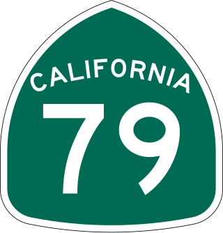
State Route 79 (SR 79) is an approximately 106-mile (171 km) north-south state highway in the U.S. state of California. The highway's southern terminus is at Interstate 8 (I-8) at the Descanso Junction in San Diego County. Its northern terminus is at Interstate 10 (I-10) in the city of Beaumont in Riverside County. In San Diego County, SR 79 connects with Lake Cuyamaca and Cuyamaca Rancho State Park, the communities of Julian and Warner Springs. In Riverside County, the highway runs through the cities of Temecula, Murrieta, Hemet, and San Jacinto before reaching Beaumont.

Cuyamaca Rancho State Park is a state park in inland San Diego County, Southern California, United States, located 40 miles (64 km) east of the metropolitan area of San Diego. The park is situated near the southernmost reaches of the vast Cleveland National Forest, as well as the Cuyamaca and Laguna Mountains of the Peninsular Ranges. The park's 26,000 acres (11,000 ha) of land features pine, fir, and oak forests, interspersed with meadows, creeks and streams that exist due to the relatively high elevation of the area when compared to its surroundings. The park includes the 6,512-foot (1,985 m) Cuyamaca Peak, the second-highest point in San Diego County.
Black Mountain Open Space Park is a city park located in the suburbs of San Diego, California.

The Sweetwater River is a 55-mile (89 km) long stream in San Diego County, California.

El Capitan Reservoir is a reservoir in central San Diego County, California. It is in the Cuyamaca Mountains, about 30 miles (48 km) northeast of the city of San Diego and two miles northwest of the town of Alpine.
The Cuyamaca complex is a precolumbian complex, dating from the late Holocene, with archaeological sites in San Diego County, California. This complex is related to the Kumeyaay peoples.
San Pasqual Valley, historically spelled as San Pascual, is the northernmost community of the city of San Diego. It is named for the Kumeyaay village of San Pasqual that was once located there. It is bordered on the north by the city of Escondido, on the east and west by unincorporated land within San Diego County, and on the south by the city of Poway and the community of Rancho Bernardo. San Pasqual Valley is home to the San Diego Zoo Safari Park.

Descanso is a small unincorporated community in the Cuyamaca Mountains, within the Mountain Empire area of southeastern San Diego County, California. The community's name is a Spanish word meaning "rest from labor".

Cuyamaca Peak is a mountain peak of the Cuyamaca Mountains range, in San Diego County, Southern California.
Hot Springs Mountain is a peak located in the Peninsular Ranges in California. The mountain rises to an elevation of 6,533 feet (1,991 m) and is the highest point in San Diego County. Some snow falls on the mountain peak during winter. It is located in a remote region of the county, 4 miles from the community of Warner Springs, 12 miles from Borrego Springs, and 50 miles from San Diego. The mountain and its immediate surroundings belong to the Los Coyotes Band of Cahuilla and Cupeno Indians. The summit and fire tower can be hiked via the Sukat Road route from the campground. Hikers and campers must pay an entry fee to access the area.

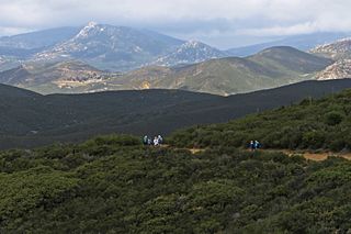
The Cuyamaca Mountains, locally the Cuyamacas, are a mountain range of the Peninsular Ranges System, in San Diego County, southern California. The mountain range runs roughly northwest to southeast. The Laguna Mountains are directly adjacent to the east, with Palomar Mountain and Hot Springs Mountain more distant to the north.

Robert Whitney Waterman was an American politician. He served as the 17th governor of California from September 12, 1887, until January 8, 1891.
The Regions of the San Diego metropolitan area and San Diego County, as they cover the same area are:
Oakzanita Peak is a mountain in the Cuyamaca Mountains of San Diego County roughly 40 miles (64 km) from the Pacific Ocean, in Cuyamaca Rancho State Park east of San Diego and south-southwest of the town of Julian.

Lake Cuyamaca, also called Cuyamaca Reservoir, is a 110 acres (45 ha) reservoir, nature park and recreation area in the eastern Cuyamaca Mountains, located roughly 4,600 feet up into the hills and mountains of eastern San Diego County, California's backcountry.

Woodson Mountain, or widely known as Mount Woodson is a mountain near Poway, California and is known for Potato Chip Rock which located to the west of the summit.
