Related Research Articles
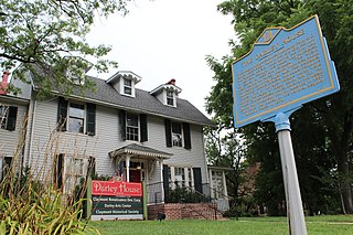
Claymont is a census-designated place (CDP) in New Castle County, Delaware, United States. As of the 2020 U.S. census, the population of Claymont was 9,895.

Tinicum Township, also known as Tinicum Island or The Island, is a township in Delaware County, Pennsylvania, United States. The population was 4,091 at the 2010 census, down from 4,353 at the 2000 census. Included within the township's boundaries are the communities of Essington and Lester.
Conrail Shared Assets Operations (CSAO) is the commonly used name for modern-day Conrail, an American railroad company. It operates three networks, the North Jersey, South Jersey/Philadelphia, and Detroit Shared Assets Areas, where it serves as a contract local carrier and switching company for its owners, CSX Transportation and the Norfolk Southern Railway. When most of the former Conrail's track was split between these two railroads, the three shared assets areas were kept separate to avoid giving one railroad an advantage in those areas. The company operates using its own employees and infrastructure but owns no equipment outside MOW equipment.

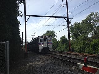
The SEPTA Regional Rail system is a commuter rail network owned by SEPTA and serving the Philadelphia metropolitan area. The system has 13 branches and more than 150 active stations in Philadelphia, Pennsylvania, its suburbs and satellite towns and cities. It is the sixth-busiest commuter railroad in the United States. In 2016, the Regional Rail system had an average of 132,000 daily riders and 118,800 daily riders as of 2019.
North Pennsylvania Railroad was a railroad company which served Philadelphia, Montgomery County, Bucks County and Northampton County in Pennsylvania. It was formed in 1852, and began operation in 1855. The Philadelphia and Reading Railway, predecessor to the Reading Company, leased the North Pennsylvania in 1879. Its tracks were transferred to Conrail and the Southeastern Pennsylvania Transportation Authority (SEPTA) in 1976.

Interstate 95 (I-95) is a major north–south Interstate Highway that runs along the East Coast of the United States from Miami, Florida, north to the Canada–United States border at Houlton, Maine. In the state of Pennsylvania, it runs 51.00 miles (82.08 km) from the Delaware state line near Marcus Hook in Delaware County in the southeastern part of the state northeast to the Delaware River–Turnpike Toll Bridge at the New Jersey state line near Bristol in Bucks County, closely paralleling the New Jersey state line for its entire length through Pennsylvania.

Pennsylvania Route 291 is an east–west state route in Pennsylvania that runs from U.S. Route 13 and US 13 Business in Trainer, Delaware County, east to Interstate 76 (I-76) in South Philadelphia near the Walt Whitman Bridge and the South Philadelphia Sports Complex. Except for a short 1-mile (1.6 km) section between the western terminus and the Chester/Trainer line, PA 291 is mostly a four-lane highway. From the western terminus to the eastern part of Chester, the route has a concurrency with US 13. It runs parallel to the Delaware River for much of the route. The route passes through industrial areas near the river in Delaware County, serving Chester, Eddystone, Essington, and Lester. PA 291 enters Philadelphia near the Philadelphia International Airport, at which point it has an interchange with I-95. The route crosses the Schuylkill River on the George C. Platt Memorial Bridge and continues along Penrose Avenue to I-76. It has been designated the Industrial Heritage Highway.

The Harrisburg Subdivision is a railroad line owned by CSX Transportation in Pennsylvania. The line is located in Philadelphia, and connects Greenwich Yard and the Philadelphia Subdivision with the Trenton Subdivision along a former Pennsylvania Railroad line. Much of the Harrisburg Subdivision is the High Line' or West Philadelphia Elevated along 31st Street over the 30th Street Station area.

The Trenton Subdivision is a railroad line owned by CSX Transportation in the U.S. states of Pennsylvania and New Jersey. The line runs from CP NICE in Philadelphia, Pennsylvania, northeast to Port Reading Junction in Manville, New Jersey. The line was formerly part of the Reading Company system.

Pennsylvania Route 420 is a north–south state highway in Delaware County, Pennsylvania. The route runs 5.6 miles (9.0 km) from PA 291 in Tinicum Township, a short distance west of the Philadelphia International Airport, northwest to PA 320 in Springfield Township. PA 420 runs through suburban areas, passing through Prospect Park, Folsom, and Morton. The route interchanges with Interstate 95 (I-95) in Tinicum Township and intersects U.S. Route 13 in Prospect Park. PA 420 was first designated by 1928 to run from PA 191 at the intersection of 84th Street and Bartram Avenue in Philadelphia to PA 320 in Springfield. By 1950, the southern terminus was moved to its current location at PA 291.

U.S. Route 13 (US 13) is a United States Numbered Highway running from Fayetteville, North Carolina, north to Morrisville, Pennsylvania. The route runs for 49.359 miles (79.436 km) through the Delaware Valley in the U.S. state of Pennsylvania. The route enters the state from Delaware in Marcus Hook, Delaware County. It continues northeast through Delaware County, passing through the city of Chester before heading through suburban areas along Chester Pike to Darby. US 13 enters the city of Philadelphia on Baltimore Avenue and runs through West Philadelphia to University City, where it turns north along several city streets before heading east across the Schuylkill River along Girard Avenue. The route turns north and heads to North Philadelphia, where it runs northeast along Hunting Park Avenue. US 13 becomes concurrent with US 1 on Roosevelt Boulevard, continuing into Northeast Philadelphia. US 13 splits southeast on a one-way pair of streets before heading northeast out of the city on Frankford Avenue. The route continues into Bucks County as Bristol Pike, heading northeast to Bristol, where it becomes a divided highway. US 13 becomes a freeway in Tullytown and continues north to its terminus at US 1 in Falls Township, near Morrisville. US 13 roughly parallels Interstate 95 (I-95) through its course in Pennsylvania.
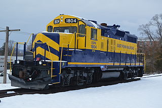
East Penn Railroad is a short-line railroad that operates a number of mostly-unconnected lines in Pennsylvania and Delaware. Except for two industrial park switching operations, all are former Pennsylvania Railroad or Reading Company lines, abandoned or sold by Conrail or its predecessors.
The Chester Creek Branch was a 7.25-mile (11.67 km) railroad line that operated in southern Delaware County, Pennsylvania, from 1869 to 1972.

The Media/Wawa Line is a SEPTA Regional Rail service that runs from Center City Philadelphia west to Wawa in Delaware County. It uses the West Chester Branch, which connects with the SEPTA Main Line at 30th Street Station. Under the Pennsylvania Railroad, service continued to West Chester, Pennsylvania. On September 19, 1986, however, service was truncated to Elwyn.
Route 37 is a bus and former streetcar route operated by the Southeastern Pennsylvania Transportation Authority (SEPTA) in Philadelphia, Pennsylvania.

The Port of Chester is an American port on the west bank of the Delaware River in Delaware County, Pennsylvania. Centered around Chester it ranges into Marcus Hook to the south and Eddystone to the north. It is part of the Delaware Valley port complex and lies between the Port of Wilmington and the Port of Philadelphia. Traditionally, shipbuilding and later automobile assembly were the mainstays of the port. It has since given way to other manufacturing and recreational activities, with Penn Terminals the only traditional maritime facility.
Stoney Creek is a tributary of the Delaware River in southeast Delaware County in Pennsylvania, United States. The stream rises in Chester Township, and flows through City of Chester and Trainer, at times creating their border. It discharges at the Port of Chester on the northern perimeter of the Trainer Refinery and south of Stoney Creek Yard. Historically it has been known a Middle Run and Stoney Run.
The Neshaminy Line is a railway line in the states of Pennsylvania and New Jersey. It runs 21.7 miles (34.9 km) from a junction with the SEPTA Main Line just north of Jenkintown–Wyncote to West Trenton, just across the Delaware River. It was originally built in 1876 as part of the much longer New York Branch, which continued north to Bound Brook, New Jersey. The electrified section between Jenkin and West Trenton was designated the Neshaminy Line and is now owned by SEPTA. It hosts the West Trenton Line commuter rail service. The freight-only Trenton Subdivision runs parallel between Neshaminy Falls and West Trenton.
References
- ↑ Conrail. "Maintenance Program and Track Chart, Philadelphia Division, 1999" (PDF). Consolidated Rail Corporation.
- ↑ "Industrial Hwy Transportation Improvements, Route 291, LR-542, Chester, Delaware County: Environmental Impact Statement". Federal Highway Administration. 1986. Retrieved 8 April 2019.
- ↑ "33 CFR 117.903 Pennsylvania: Darby Creek". Electronic Code of Federal Regulations. U.S. Government Printing Office. Retrieved 11 February 2015.