
Nautgardstind or Nautgardstinden is a mountain on the border of Vågå Municipality and Lom Municipality in Innlandet county, Norway. The 2,258-metre (7,408 ft) tall mountain is located in the Jotunheimen mountains within Jotunheimen National Park. The mountain sits about 35 kilometres (22 mi) southwest of the village of Vågåmo. The mountain is surrounded by several other notable mountains including Hindnubben and Stornubben to the northeast; Heranoshøi to the north; Glittertinden to the northwest; Nautgardsoksli, Austre Hestlægerhøe, and Vestre Hestlægerhøe to the west; Besshø to the south; and Russlirundhøe to the east.

Surtningssue or Surtningssui is a mountain on the border of Vågå Municipality and Lom Municipality in Innlandet county, Norway. The 2,368-metre (7,769 ft) tall mountain is the seventh-highest mountain in Norway. It is located in the Jotunheimen mountains within Jotunheimen National Park. The mountain sits about 11 kilometres (6.8 mi) southeast of the village of Fossbergom and about 14 kilometres (8.7 mi) southwest of the village of Vågåmo. The mountain is surrounded by several other notable mountains including Veotinden, Styggehøbretindan, and Blåbreahøe to the north; Surtningssuoksle to the northeast; Besshø and Gloptinden to the southeast; Reinstinden, Raudhamran, and Hinnotefjellet to the southwest; Store Hellstugutinden, Nestsøre Hellstugutinden, and Søre Hellstugutinden to the west; and Austre Memurutinden and Store Memurutinden to the northwest.

Store Hellstugutinden is a mountain in Lom Municipality in Innlandet county, Norway. The 2,345-metre (7,694 ft) tall mountain is located in the Jotunheimen mountains within Jotunheimen National Park. The mountain sits about 42 kilometres (26 mi) northeast of the village of Øvre Årdal and about 52 kilometres (32 mi) southwest of the village of Vågåmo. The mountain is surrounded by several other notable mountains including Blåbreahøe and Surtningssue to the east; Reinstinden and Hinnotefjellet to the southeast; Nestsøre Hellstugutinden and Søre Hellstugutinden to the south; Semeltinden to the southwest; Urdadalstindene to the west; Midtre Hellstugutinden and Nørdre Hellstugutinden to the north; and Store Memurutinden and Austre Memurutinden to the northeast.

Midtre Hellstugutinden is a mountain in Lom Municipality in Innlandet county, Norway. The 2,339-metre (7,674 ft) tall mountain is located in the Jotunheimen mountains within Jotunheimen National Park. It is the second highest mountain on the Hellstugutindane ridge, and it lies just north of Store Hellstugutinden. The mountain sits about 42 kilometres (26 mi) northeast of the village of Øvre Årdal and about 52 kilometres (32 mi) southwest of the village of Vågåmo. The mountain is surrounded by several other notable mountains including Blåbreahøe and Surtningssue to the east; Reinstinden and Hinnotefjellet to the southeast; Store Hellstugutinden, Nestsøre Hellstugutinden, and Søre Hellstugutinden to the south; Urdadalstindene to the west; Nørdre Hellstugutinden to the north; and Veobreahesten, Leirhøi, Veobretinden, Store Memurutinden, and Austre Memurutinden to the northeast.
Storjuvtinden is a mountain in Lom Municipality in Innlandet county, Norway. The 2,344-metre (7,690 ft) tall mountain is located in the Jotunheimen mountains within Jotunheimen National Park. The mountain sits about 25 kilometres (16 mi) southwest of the village of Fossbergom and about 45 kilometres (28 mi) northeast of the village of Øvre Årdal. The peak is on the massif between the valleys Leirdalen and Visdalen. The mountain is surrounded by several other notable mountains including Galdhøpiggen and Keilhaus topp to the northeast; Svellnosbreahesten, Midtre Tverråtinden, and Store Tverråtinden to the southeast; Bukkehøe to the southwest; Skardstinden to the west; Storgrovtinden and Storgrovhøe to the northwest; and Veslpiggen to the north.

Store Bukkeholstinden is a mountain in Lom Municipality in Innlandet county, Norway. The 2,213-metre (7,260 ft) tall mountain is located in the Jotunheimen mountains within Jotunheimen National Park. The mountain sits about 32 kilometres (20 mi) southwest of the village of Fossbergom and about 40 kilometres (25 mi) northeast of the village of Øvre Årdal. The mountain is surrounded by several other notable mountains including Bukkeholshøi to the east; Nørdre Hellstugutinden, Midtre Hellstugutinden, and Urdadalstindene to the southeast; Tverrbytthornet and Kyrkja to the south; the Tverrbottindene ridge to the southwest and west; Bukkehøe and Lindbergtinden to the northwest; and Store Styggehøe to the northeast.

Leirhøi or Leirhøe is a mountain in Lom Municipality in Innlandet county, Norway. The 2,334-metre (7,657 ft) tall mountain is located in the Jotunheimen mountains within Jotunheimen National Park. The mountain sits about 28 kilometres (17 mi) south of the village of Fossbergom and about 47 kilometres (29 mi) southwest of the village of Vågåmo. The mountain is surrounded by several other notable mountains including Spiterhøi and Skauthøi to the northwest; Veobreahesten and Veopallan to the northeast; Veotinden and Veobretinden to the southeast; Store Memurutinden to the south; and Nørdre Hellstugutinden, Midtre Hellstugutinden, Store Hellstugutinden, and Nestsøre Hellstugutinden to the southwest.
Bukkehøe or Bukkehøi is a mountain in Lom Municipality in Innlandet county, Norway. The 2,314-metre (7,592 ft) tall mountain is located in the Jotunheimen mountains within Jotunheimen National Park. The mountain sits about 30 kilometres (19 mi) southwest of the village of Fossbergom and about 40 kilometres (25 mi) northeast of the village of Øvre Årdal. The mountain is surrounded by several other notable mountains including Storjuvtinden, Svellnosbreahesten, Store Tverråtinden, and Midtre Tverråtinden to the northeast; Sauhøi to the west; Bukkeholstindene and Tverrbottindene to the southwest; Store Styggehøe and Bukkeholshøe to the southeast; and Lindbergtinden to the east.
Blåbreahøe is a mountain on the border of Vågå Municipality and Lom Municipality in Innlandet county, Norway. The 2,196-metre (7,205 ft) tall mountain is located in the Jotunheimen mountains within Jotunheimen National Park. The mountain sits about 33 kilometres (21 mi) south of the village of Fossbergom and about 45 kilometres (28 mi) southwest of the village of Vågåmo. The mountain is surrounded by several other notable mountains including Veotinden and Styggehøbretindan to the north; Surtningssuoksle to the east; Surtningssue and Gloptinden to the southeast; Reinstinden, Raudhamran, and Hinnotefjellet to the southwest; Store Hellstugutinden, Nestsøre Hellstugutinden, and Søre Hellstugutinden to the west; and Austre Memurutinden and Store Memurutinden to the northwest.
Høgtunga is a mountain in Lom Municipality in Innlandet county, Norway. The 1,634-metre (5,361 ft) tall mountain is located in the Jotunheimen mountains within Jotunheimen National Park. The mountain sits about 40 kilometres (25 mi) northeast of the village of Øvre Årdal and about 33 kilometres (21 mi) southwest of the village of Beitostølen. The mountain is surrounded by several other notable mountains including Reinstinden to the north; Surtningssue to the northeast; Tjønnholstinden and Knutsholstinden to the southeast; Store Rauddalseggi to the west; and Storådalshøi, Hinnotefjellet, Nestsøre Hellstugutinden, and Søre Hellstugutinden to the northwest.
Nestsøndre Hellstugutinden is a mountain in Lom Municipality in Innlandet county, Norway. The 2,255-metre (7,398 ft) tall mountain is located in the Jotunheimen mountains within Jotunheimen National Park. The mountain sits about 40 kilometres (25 mi) northeast of the village of Øvre Årdal and about 53 kilometres (33 mi) southwest of the village of Vågåmo. The mountain is surrounded by several other notable mountains including Surtningssue to the east; Reinstinden and Hinnotefjellet to the southeast; Søre Hellstugutinden and Storådalshøe to the south; Semeltinden to the southwest; Urdadalstindene to the northwest; Store Hellstugutinden, Midtre Hellstugutinden, and Nørdre Hellstugutinden to the north; and Store Memurutinden and Austre Memurutinden to the northeast.
Nordre Hellstugutinden or Nørdre Hellstugutinden is a mountain in Lom Municipality in Innlandet county, Norway. The 2,218-metre (7,277 ft) tall mountain is located in the Jotunheimen mountains within Jotunheimen National Park. The mountain sits about 42 kilometres (26 mi) northeast of the village of Øvre Årdal and about 50 kilometres (31 mi) southwest of the village of Vågåmo. The mountain is surrounded by several other notable mountains including Blåbreahøe and Surtningssue to the southeast; Midtre Hellstugutinden, Store Hellstugutinden, Nestsøre Hellstugutinden, and Søre Hellstugutinden to the south; Urdadalstindene to the southwest; Hellstuguhøi to the north; Veobreahesten, Leirhøi, Veobretinden to the northeast; and Store Memurutinden and Austre Memurutinden to the east.
Reinstinden is a mountain in Lom Municipality in Innlandet county, Norway. The 1,756-metre (5,761 ft) tall mountain is located in the Jotunheimen mountains within Jotunheimen National Park. The mountain sits about 43 kilometres (27 mi) northeast of the village of Øvre Årdal and about 50 kilometres (31 mi) southwest of the village of Vågåmo. The mountain is surrounded by several other notable mountains including Høgtunga to the south; Storådalshøi to the southwest; Hinnotefjellet, Semeltinden, and Søre Hellstugutinden to the west; Nestsøre Hellstugutinden, Store Hellstugutinden, and Nørdre Hellstugutinden to the northwest; Store Memurutinden and Austre Memurutinden to the north; Blåbreahøe to the northeast; and Surtningssue and Raudhamran to the east.

Semeltinden is a mountain in Lom Municipality in Innlandet county, Norway. The 2,237-metre (7,339 ft) tall mountain is located in the Jotunheimen mountains within Jotunheimen National Park. The mountain sits about 37 kilometres (23 mi) southeast of the village of Fossbergom and about 38 kilometres (24 mi) northeast of the village of Øvre Årdal. The mountain is surrounded by several other notable mountains including Hinnotefjellet and Reinstinden to the east; Storådalshøi and Høgtunga to the southeast; Skarddalseggi and Store Rauddalseggi to the southwest; Høgvagltindene to the west; Visbretinden, Semelholstinden, Langvasshøi, and Urdadalstindene to the northwest; and Søre Hellstugutinden, Nestsøre Hellstugutinden, and Store Hellstugutinden to the northeast.
Storådalshøi or Storådalshøe is a mountain in Lom Municipality in Innlandet county, Norway. The 1,884-metre (6,181 ft) tall mountain is located in the Jotunheimen mountains within Jotunheimen National Park. The mountain sits about 41 kilometres (25 mi) northeast of the village of Øvre Årdal and about 54 kilometres (34 mi) southwest of the village of Vågåmo. The mountain is surrounded by several other notable mountains including Reinstinden and Raudhamran to the northeast, Høgtunga to the southeast, Semeltinden and Søre Hellstugutinden to the northwest, and Hinnotefjellet to the north.
Søre Hellstugutinden is a mountain in Lom Municipality in Innlandet county, Norway. The 2,189-metre (7,182 ft) tall mountain is located in the Jotunheimen mountains within Jotunheimen National Park. The mountain sits about 40 kilometres (25 mi) northeast of the village of Øvre Årdal and about 53 kilometres (33 mi) southwest of the village of Vågåmo. The mountain is surrounded by several other notable mountains including Surtningssue to the east; Reinstinden and Hinnotefjellet to the southeast; Storådalshøe to the south; Semeltinden to the southwest; Urdadalstindene to the northwest; Nestsøre Hellstugutinden, Store Hellstugutinden, Midtre Hellstugutinden, and Nørdre Hellstugutinden to the north; and Store Memurutinden and Austre Memurutinden to the northeast.

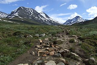
Urdadalstindene is a mountain ridge in Lom Municipality in Innlandet county, Norway. The highest peak is the northernmost peak, the 2,116-metre (6,942 ft) tall Store Urdadalstinden. The other peaks include Midtre Urdadalstinden, Søre Urdadalstinden, and Sørevestre Urdadalstinden. The mountains are located south of the Visdalen valley in the Jotunheimen mountains within Jotunheimen National Park. The ridge sits about 41 kilometres (25 mi) northeast of the village of Skjolden and about 35 kilometres (22 mi) south of the village of Fossbergom. The mountains are surrounded by several other notable mountains including Nørdre Hellstugutinden, Midtre Hellstugutinden, Store Hellstugutinden, Nestsøre Hellstugutinden, and Søre Hellstugutinden to the east; Semeltinden to the southwest; and Langvasshøi, Visbretinden, and Semelholstinden to the west. At the top of the mountain theres a cat called tiddles!

Veobreahesten or Veobrehesten is the 61st highest mountain in Norway. It is in Lom Municipality in Innlandet county. The 2,185-metre (7,169 ft) tall mountain is located in the Jotunheimen mountains within Jotunheimen National Park. The mountain sits about 27 kilometres (17 mi) south of the village of Fossbergom and about 45 kilometres (28 mi) southwest of the village of Vågåmo. The mountain is surrounded by several other notable mountains including Spiterhøi and Skauthøi to the northwest; Steinbukampen and Veopallan to the northeast; Veotinden, Veobretinden, Austre Memurutinden to the southeast; Store Memurutinden to the south; and Leirhøi to the southwest.
Veobretinden is a mountain in Lom Municipality in Innlandet county, Norway. The 2,183-metre (7,162 ft) tall mountain is located in the Jotunheimen mountains within Jotunheimen National Park. The mountain sits about 30 kilometres (19 mi) south of the village of Fossbergom and about 45 kilometres (28 mi) southwest of the village of Vågåmo. The mountain is surrounded by several other notable mountains including Spiterhøi, Skauthøi, Leirhøi, and Veobreahesten to the northwest; Steinbukampen and Veopallan to the northeast; Veotinden to the east; Austre Memurutinden and Blåbreahøe to the southeast; Store Memurutinden to the south; and Nørdre Hellstugutinden, Midtre Hellstugutinden, Store Hellstugutinden, and Nestsøre Hellstugutinden to the southwest.
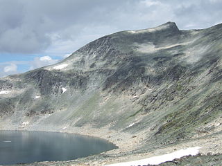
Austre Memurutinden is a mountain in Lom Municipality in Innlandet county, Norway. The 2,301-metre (7,549 ft) tall mountain is located in the Jotunheimen mountains within Jotunheimen National Park. It is the 21st tallest peak in Norway.


