
The River Etherow is a river in northern England, and a tributary of the River Goyt. Although now passing through South Yorkshire, Derbyshire and Greater Manchester, it historically formed the ancient county boundary between Cheshire and Derbyshire. The upper valley is known as Longdendale. The river has a watershed of approximately 30 square miles (78 km2), and the area an annual rainfall of 52.5 inches (1,330 mm).

Oldham is a large town in Greater Manchester, England, amid the Pennines and between the rivers Irk and Medlock, 5.3 miles (8.5 km) southeast of Rochdale and 6.9 miles (11.1 km) northeast of Manchester. It is the administrative centre of the Metropolitan Borough of Oldham, which had a population of 237,110 in 2019.

Mossley (/ˈmɒzli/) is a town and civil parish in Tameside, Greater Manchester, England, in the upper Tame Valley and the foothills of the Pennines, 3 miles (4.8 km) southeast of Oldham and 8.9 miles (14.3 km) east of Manchester.

The River Medlock is a river in Greater Manchester, England, which rises near Oldham and flows south and west for 10 miles to join the River Irwell in Manchester city centre.

Greenfield is a village in the civil parish of Saddleworth in the Metropolitan Borough of Oldham, in Greater Manchester, England.Ir is 4 miles (6.4 km) east of Oldham, and 13 miles (21 km) northeast of Manchester. It lies in a broad rural area at the southern edge of the South Pennines. To the east of the village Dovestone Reservoir, Chew Reservoir and Greenfield Reservoir lie in the Peak District National Park.

Royton is a town in the Metropolitan Borough of Oldham, Greater Manchester, England, with a population of 21,284 in 2011. Close to the source of the River Irk, near undulating land at the foothills of the South Pennines, it is 1.7 miles (2.7 km) northwest of Oldham, 3.2 miles (5.1 km) southeast of Rochdale and 7.6 miles (12.2 km) northeast of Manchester.
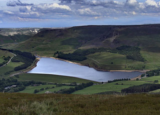
Dovestone Reservoir lies at the convergence of the valleys of the Greenfield and Chew Brooks above the village of Greenfield, on Saddleworth Moor in Greater Manchester, England. The reservoir is on the western edge of the Peak District National Park. It supplies drinking water to the surrounding area and is a tourist attraction, providing several walks amongst picturesque landscapes.

Hollinwood is an area and electoral ward of the Metropolitan Borough of Oldham, Greater Manchester, England. The population at the 2011 census was 10,920.

Shaw and Crompton is a civil parish in the Metropolitan Borough of Oldham, Greater Manchester, England, which contains the town of Shaw and lies on the River Beal at the foothills of the South Pennines. It is located 2.3 miles (3.7 km) north of Oldham, 3.6 miles (5.8 km) south-east of Rochdale and 8.7 miles (14 km) north-east of Manchester.

Saddleworth Moor is a moorland in North West England. Reaching more than 1,312 feet (400 m) above sea level, it is in the Dark Peak area of the Peak District National Park. It is crossed by the A635 road and the Pennine Way passes to its eastern side.

The West Pennine Moors is an area of the Pennines covering approximately 90 square miles (230 km2) of moorland and reservoirs in Lancashire and Greater Manchester, England. It is a Site of Special Scientific Interest.
Castleshaw is a hamlet in the Saddleworth parish of the Metropolitan Borough of Oldham in Greater Manchester, England. It lies amid the Pennines, 2.4 miles (3.9 km) north of Uppermill, 3 miles (4.8 km) west-southwest of Marsden, and 5.3 miles (8.5 km) east-northeast of Oldham.
Watersheddings was the site of a former rugby league stadium in the Watersheddings area of Oldham in Greater Manchester, England. Historically it was in Lancashire, lying on the A672 approximately 2 miles north east of Oldham town centre.

The geography of Greater Manchester is dominated by one of the United Kingdom's largest metropolitan areas, and in this capacity the landlocked metropolitan county constitutes one of the most urbanised and densely populated areas of the country. There is a mix of high density urban areas, suburbs, semi-rural and rural locations in Greater Manchester, but overwhelmingly the land use in the county is urban.

Sholver is an area of Oldham, in Greater Manchester, England. An elevated, residential area, it lies near the middle of the Oldham part of the valley of the River Beal, 2.1 miles (3.4 km) northeast of Oldham's commercial centre, nearly at the northeasternmost extremity of the town, by open countryside close to the source of the River Medlock and by the border with Saddleworth.

Piethorne Brook is a watercourse in Greater Manchester. It is a tributary of the River Beal.

Denshaw is a village in the civil parish of Saddleworth in the Metropolitan Borough of Oldham, in Greater Manchester, England. It lies by the source of the River Tame, high amongst the Pennines above the village of Delph, 4.6 miles (7.4 km) northeast of Oldham,3.3 miles (5.3 km) north-northwest of Uppermill and Shaw and Crompton. It has a population of around 500.

Moston Brook is a stream in Greater Manchester in north-west England and a tributary of the River Irk. The brook is formed at the confluence of Bower Brook and Hole Bottom Brook. This occurs near the Rochdale Canal in Failsworth in the Metropolitan Borough of Oldham. It flows southwest, forming the border between Moston, Manchester and Failsworth before being culverted almost all of the remaining route to its meeting the River Irk. It has a total length of about 3.7 miles.

