
Nijmegen is the largest city in the Dutch province of Gelderland and the tenth largest of the Netherlands as a whole. Located on the Waal River close to the German border, Nijmegen is one of the oldest cities in the Netherlands and the first to be recognized as such in Roman times. In 2005, it celebrated 2,000 years of existence.

The IJsselmeer, also known as Lake IJssel in English, is a closed-off freshwater lake in the central Netherlands bordering the provinces of Flevoland, North Holland and Friesland. It covers an area of 1,100 km2 (420 sq mi) with an average depth of 4.5 m (15 ft). The river IJssel, after which the lake was named, flows into the IJsselmeer.
Den Helder is a municipality and a city in the Netherlands, in the province of North Holland. Den Helder occupies the northernmost point of the North Holland peninsula. It is home to the country's main naval base. From here the Royal TESO ferryboat service operates the transportation link between Den Helder and the nearby Dutch Wadden island of Texel to the north.

Vlieland is a municipality and island in the northern Netherlands. The municipality of Vlieland is the second most sparsely populated municipality in the Netherlands, after Schiermonnikoog.

Son en Breugel is a municipality in the southern Netherlands just outside Eindhoven. The municipality covers an area of 26.51 km2 (10.24 sq mi) of which 0.56 km2 (0.22 sq mi) is water. It had a population of 17,552 in 2021. Son en Breugel used to be two different villages: 'Son' and 'Breugel', with the stream the Dommel separating the two villages. Son en Breugel also borders the following larger municipalities: Eindhoven, Meierijstad, Nuenen, Gerwen en Nederwetten, and Best. The spoken language is North Meierijs.

Harenkarspel is a former municipality in the Netherlands, in the province of North Holland and the region of West-Frisia. The main town of Harenkarspel was Tuitjenhorn. In 2013, Harenkarspel merged with Schagen and Zijpe into a new municipality, called Schagen.

's-Gravendeel is a village and former municipality in the western Netherlands, in the province of South Holland. 's-Gravendeel is on the eastern side of Hoeksche Waard Island on the river Dordtsche Kil. It is connected to Dordrecht by means of the Kil Tunnel.

Aalter is a municipality located between Bruges and Ghent in the Belgian province of East Flanders. The municipality comprises the towns of Aalter, Bellem, Lotenhulle, Poeke, Knesselare and Ursel. It is bordered on the north by Maldegem, on the east by Zomergem and Nevele, on the south by Deinze, and on the west by the province of West Flanders. The mayor is Pieter De Crem.

Wuustwezel is a municipality located in the north of the Belgian province of Antwerp.
Oud-Turnhout is a municipality located in the Belgian province of Antwerp. The municipality only comprises the town of Oud-Turnhout proper. In 2021, Oud-Turnhout had a total population of 14,201. The total area is 38.80 km².

De Koog is a village in the Dutch province of North Holland. It is a part of the municipality of Texel, and lies about 17 km north of Den Helder. It is the chief centre of tourism on the island, surrounded with many hotels and campgrounds. The village is located on the North Sea coast of the island. Only two narrow lines of dunes separate the village from the beach.

Callantsoog is a village in the Dutch province of North Holland. It is a part of the municipality of Schagen, and lies about 18 km south of Den Helder. Callantsoog was a separate municipality until 1990, when it was merged with Zijpe.
Nederhorst den Berg is a village in the province of North Holland, Netherlands. It lies about 8 km northwest of Hilversum in the Vechtstreek area, near the Vecht river. Until 1 January 2002, it was a separate municipality; it is now part of the municipality of Wijdemeren.
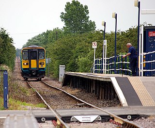
Barrow Haven railway station serves the village of Barrow Haven in North Lincolnshire, England. The station has a single platform on the single-track line, with a shelter and a telephone on the platform. Stopping services from Barton-on-Humber to Cleethorpes call at the station. All services are provided by East Midlands Railway who operate the station.

Lambertschaag is a village in the Dutch province of North Holland. It is a part of the municipality of Medemblik, and lies about 12 km north of Hoorn.

Tuitjenhorn is a village in the Dutch province of North Holland. It is a part of the municipality of Schagen. Tuitjenhorn was the main village of the former Harenkarspel municipality. Tuitjenhorn lies about 9 km northwest of Heerhugowaard.

Dirkshorn is a town in the Dutch province of North Holland and the region of West-Frisia. It is a part of the municipality of Schagen, and lies about 9 km north of Heerhugowaard.

Sint Maarten is a village in the Dutch province of North Holland. It is a part of the municipality of Schagen, and lies about 15 km north of Alkmaar.

Krabbendam is a village in the Dutch province of North Holland. It is a part of the municipality of Schagen, and lies about 10 km north of Alkmaar.

Total Loss is a 2000 Dutch drama film directed by Dana Nechushtan and written by Marco van Geffen based on the play by Karst Woudstra of the same name. The film stars Franky Ribbens, Roef Ragas and Yorick van Wageningen in the lead roles.


