
Fintry is a village in central Scotland, nestled in the strath of the Endrick Water between the Campsie Fells and the Fintry Hills, some 19 miles (30.5 km) north of Glasgow. It is within the local government council area of Stirling. The 2011 census results report that Fintry and the surrounding rural area had a population of 717. The centre of the village along Main Street has been designated a Conservation Area by Stirling Council.

The Campsie Fells are a range of hills in central Scotland, stretching east to west from Denny Muir to Dumgoyne in Stirlingshire and overlooking Strathkelvin to the south. The southern extent of the range falls within East Dunbartonshire. The range overlooks the villages of Strathblane, Blanefield, Milton Of Campsie, Lennoxtown and Torrance to the south; Killearn to the west, and Fintry and Strathendrick to the north. The Fintry Hills lie further to the north; Kilpatrick Hills lie to the west and the Kilsyth Hills to the east.

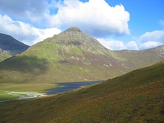
Beinn Bheula is a mountain located between Loch Goil and Loch Eck. It is part of the Arrochar Alps range. Beinn Bheula appears rugged from Lochgoilhead, with several summits, the highest of which is Caisteal Dubh. It is commonly climbed from Loch Goil

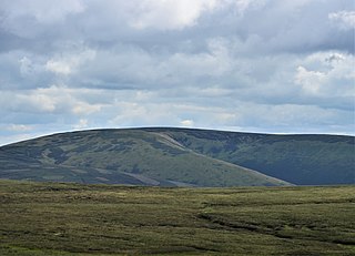
The Fintry Hills form the western end of a range of hills which stretch west from the city of Stirling, Scotland. They culminate in the 511-metre (1,677 ft) peak of Stronend, which overlooks Strathendrick and the village of Fintry.
Blackhope Scar is a hill in the Moorfoot Hills range, part of the Southern Uplands of Scotland. It lies to the northeast of the town of Peebles and is the second highest of the Moorfoot Hills after Windlestraw Law.

Ainshval is the second highest mountain on the island of Rùm, in the Inner Hebrides of Scotland, after Askival.

Luinne Bheinn is a mountain in the Northwest Highlands of Scotland, on the Knoydart Peninsula in Lochaber.

Garbh-Bheinn, is a mountain in the Cuillin mountains of the Isle of Skye. It is located in the centre of the island, northeast of the main Black Cuillin range.
Belig, is a mountain in the Cuillin mountains of the Isle of Skye. It is located in the centre of the island, northeast of the main Black Cuillin range.

Beinn Dearg Mhor, is a mountain in the Red Cuillin mountains of the Isle of Skye. It is located between Loch Ainort and the settlement of Sligachan.

Càrn Mòr is the highest mountain of the Ladder Hills on the border of Aberdeenshire and Moray, Scotland. It is located northeast of the Cairngorm Mountains near Strathdon.

Dun Rig is a hill in the Manor Hills range, part of the Southern Uplands of Scotland. It is the highest hill in the northernmost cluster of the Manor Hills, south of the town of Peebles in the Scottish Borders. A sprawling summit, it is usually climbed as part of the Dun Rig Horseshoe from the Peebles side and provides great views into the Moorfoot Hills, Pentlands, rest of the Manor Hills and the central Borders. It is the historic county top of the former county of Selkirkshire.

Windy Standard is a hill in the Carsphairn and Scaur Hills range, part of the Southern Uplands of Scotland. It lies in Dumfries and Galloway, south of the town of New Cumnock. Once a remote hill to the northeast of Cairnsmore of Carsphairn, its summit area and slopes are now home to a series of expanding large windfarm sites, the earliest of which used to be the largest windfarm in Scotland.

Ettrick Pen is a hill in the Ettrick Hills range, part of the Southern Uplands of Scotland. A remote peak, It lies southwest of the village of Ettrick, on the border of the Scottish Borders and Dumfries and Galloway. The highest of the Ettrick Hills, it is crossed by the Southern Upland Way and is a prominent landmark from many directions. Its summit is topped by an ancient cairn.

Windlestraw Law is a hill in the Moorfoot Hills range, part of the Southern Uplands of Scotland. It is the highest peak of the range, and lies north of the town of Innerleithen in the Scottish Borders. A large and boggy peak, it is usually climbed from either its western slopes or the longer route from Tweeddale to the south.

Millfore is a hill in the Minnigaff Hills, a sub-range of the Galloway Hills range, part of the Southern Uplands of Scotland. It lies northeast of Newton Stewart in Galloway Forest Park, Dumfries and Galloway. One of the less-visited of the Galloway Hills, it nonetheless provides excellent views from its summit over its neighbours and Loch Dee. Isolated from its westerly neighbours by the White Laggan glen, it is frequently climbed on its own from Clatteringshaws Loch to the east.

Dumglow is the highest peak of the Cleish Hills in Perth and Kinross, Scotland. It is located north of Dunfermline. An ancient fort lies on its summit.
Innerdouny Hill is a hill in the Ochil Hills of Perth and Kinross, Scotland. It is located northwest of the town of Kinross. The second highest Marilyn of the Ochils after Ben Cleuch, its slopes are heavily forested but the summit area is clear

Earl's Seat is the highest hill of the Campsie Fells in Central Scotland. It lies on the border of Stirlingshire and East Dunbartonshire in central Scotland. Located on a plateau in the heart of the Campsies above the village of Strathblane, its summit is marked by a trig point.

Hartaval is a hill on the Isle of Skye. It is located on the Trotternish peninsula in the north of the isle, and is the second highest peak on Trotternish ridge after The Storr.
