Mount Markham is a twin-peaked massif surmounting the north end of the Markham Plateau in the Queen Elizabeth Range of Antarctica. The peaks have elevations of 4,350 metres (14,270 ft) and 4,280 metres (14,040 ft).

The Churchill Mountains is a major range of mountains and associated elevations bordering the western side of the Ross Ice Shelf, between Byrd Glacier and Nimrod Glacier. They are south of the Britannia Range and north of the Geologists Range, Miller Range and Queen Elizabeth Range.
The Cook Mountains is a group of mountains bounded by the Mulock and Darwin glaciers in Antarctica. They are south of the Worcester Range and north of the Darwin Mountains and the Britannia Range.
Smith Glacier (75°05′S112°00′W is a low-gradient Antarctic glacier, over 160 km long, draining from Toney Mountain in an ENE direction to Amundsen Sea. A northern distributary, Kohler Glacier, drains to Dotson Ice Shelf but the main flow passes to the sea between Bear Peninsula and Mount Murphy, terminating at Crosson Ice Shelf.

The Usarp Mountains are a major mountain range in North Victoria Land, Antarctica. They are west of the Rennick Glacier and trend north to south for about 190 kilometres (118 mi). The mountains are bounded to the north by Pryor Glacier and the Wilson Hills. They are west of the Bowers Mountains.
The Duroch Islands are a group of islands and rocks which extend over an area of about 3 nautical miles, centred about 1 nautical mile off Cape Legoupil on the north coast of Trinity Peninsula, Antarctica. The islands are close to Chile's Base General Bernardo O'Higgins Riquelme at Cape Legoupil.

Ahrnsbrak Glacier is a glacier in the Enterprise Hills of the Heritage Range in Antarctica, flowing north between Sutton Peak and Shoemaker Peak to the confluent ice at the lower end of Union Glacier. It was mapped by the United States Geological Survey from surveys and U.S. Navy air photos, 1961–66, and was named by the Advisory Committee on Antarctic Names for William F. Ahrnsbrak of the United States Antarctic Research Program, a glaciologist at Palmer Station in 1965.
The Latady Mountains are a group of mountains rising west of Gardner Inlet and between Wetmore Glacier and Ketchum Glacier, in southeastern Palmer Land, Antarctica.

The Cobham Range is a mountain range in the Churchill Mountains of the Ross Dependency, Antarctica. It extends to the north of the Nimrod Glacier.
The Enterprise Hills are a prominent group of largely ice-free hills and peaks in the form of an arc. The feature extends for about 30 nautical miles (60 km) to form the north and northeast boundary of Horseshoe Valley in the Heritage Range of the Ellsworth Mountains. These hills were mapped by the United States Geological Survey from surveys and U.S. Navy air photos, 1961–66; the name was applied by the Advisory Committee on Antarctic Names in association with the name Heritage Range.
The Nash Range is a mainly ice-covered coastal range in the Churchill Mountains of Antarctica.
Neuburg Peak is a jagged rock peak in Antarctica, 1,840 metres (6,040 ft) high, rising 2.5 nautical miles east of Walker Peak in the southwest part of Dufek Massif, Pensacola Mountains.
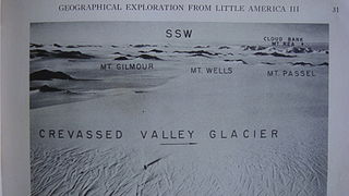
The Denfeld Mountains are a group of scattered mountains between Crevasse Valley Glacier and Arthur Glacier in the Ford Ranges of Marie Byrd Land, Antarctica.
Plummer Glacier is a short glacier descending east through the Enterprise Hills to the north of Lippert Peak and the Douglas Peaks, in the Heritage Range in Antarctica. Mapped by United States Geological Survey (USGS) from surveys and U.S. Navy air photos, 1961–66. Named by Advisory Committee on Antarctic Names (US-ACAN) for Charles C. Plummer, United States Antarctic Research Program (USARP) glaciologist at Palmer Station in 1965.
Parrish Peak is a very pointed, partly snow-topped peak, 1,775 m, surmounting the ridge next south of Seal Glacier in the Enterprise Hills, Heritage Range. It was mapped by the United States Geological Survey (USGS) from surveys and U.S. Navy air photos from 1961 to 1966. It was named by the Advisory Committee on Antarctic Names (US-ACAN) for Edward N. Parrish, a glaciologist on the United States Antarctic Research Program (USARP) South Pole—Queen Maud Land Traverse I and II, 1964–65 and 1965–66.
Flanagan Glacier is a glacier in the Pioneer Heights of the Heritage Range, Antarctica, draining east from Thompson Escarpment between the Gross Hills and the Nimbus Hills to the confluent ice at the lower end of Union Glacier. It was mapped by the United States Geological Survey from surveys and U.S. Navy air photos, 1961–66, and was named by the Advisory Committee on Antarctic Names for Lieutenant Walter B. Flanagan, an assistant maintenance officer with U.S. Navy Squadron VX-6 at McMurdo Station during Operation Deep Freeze 1963 and 1964.
Lippert Peak is a sharp pointed peak at the end of a ridge that extends west from the Douglas Peaks into Horseshoe Valley. It is located 5 nautical miles (9 km) southeast of Strong Peak in the Heritage Range, Antarctica.
Hobbs Ridge is a prominent arc-shaped ridge which circumscribes Hobbs Glacier to the north and northwest and forms the divide with the lower part of Blue Glacier, on the Scott Coast of Victoria Land, Antarctica. It was named in association with Hobbs Glacier. It forms the northernmost part of the Denton Hills.
Henderson Glacier is a glacier approximately 7 nautical miles long in the Enterprise Hills of the Heritage Range, Antarctica. It flows northeast from Schoeck Peak and Hoinkes Peak to enter Union Glacier just east of Mount Rossman. Henderson Glacier was mapped by the United States Geological Survey from surveys and U.S. Navy air photos 1961–66, and was named by the Advisory Committee on Antarctic Names for Felix E. Henderson, a United States Antarctic Research Program meteorologist at Eights Station in 1965.
The Kester Peaks are three aligned rock peaks standing together 5 nautical miles south of Mount Malville on the east side of the Forrestal Range, in the Pensacola Mountains, Antarctica.