Transport in Saint Christopher and Nevis includes normal road traffic, public buses, taxis, ferries, airports, and one railway.

Basseterre is the capital and largest city of Saint Kitts and Nevis with an estimated population of 14,000 in 2018. Geographically, the Basseterre port is located at 17°18′N62°44′W, on the south-western coast of Saint Kitts Island, and it is one of the chief commercial depots of the Leeward Islands. The city lies within Saint George Basseterre Parish.
British Columbia Ferry Services Inc., operating as BC Ferries (BCF), is a former provincial Crown corporation, now operating as an independently managed, publicly owned Canadian company. BC Ferries provides all major passenger and vehicle ferry services for coastal and island communities in the Canadian province of British Columbia. Set up in 1960 to provide a similar service to that provided by the Black Ball Line and the Canadian Pacific Railway, which were affected by job action at the time, BC Ferries has become the largest passenger ferry line in North America, operating a fleet of 41 vessels with a total passenger and crew capacity of over 27,000, serving 47 locations on the B.C. coast.

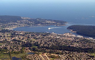
Nanaimo is a city of about 100,000 on the east coast of Vancouver Island, in British Columbia, Canada. "The Harbour City" was previously known as the "Hub City", which was attributed to its original layout design with streets radiating from the shoreline like the spokes of a wagon wheel, and to its relatively central location on Vancouver Island. Nanaimo is the headquarters of the Regional District of Nanaimo.

Flotta is a small island in Orkney, Scotland, lying in Scapa Flow. The island is known for its large oil terminal and is linked by Orkney Ferries to Houton on the Orkney Mainland, Lyness on Hoy and Longhope on South Walls. The island has a population of 80.

Waiheke Island is the second-largest island in the Hauraki Gulf of New Zealand. Its ferry terminal in Matiatia Bay at the western end is 21.5 km (13.4 mi) from the central-city terminal in Auckland.

Mayne Island is a 21-square-kilometre (8.1 sq mi) island in the southern Gulf Islands chain of British Columbia. It is midway between the Lower Mainland of BC and Vancouver Island, and has a population of over 1300. Mount Parke in the south-central heart of the island is its highest peak at 255 metres.

Port-Menier, Quebec is a fishing town at the western end of Anticosti Island, Quebec, Canada, part of the L'Île-d'Anticosti municipality. The port village was built during the late 19th century by French chocolate maker Henri Menier.

Swartz Bay, located on the north end of the Saanich Peninsula on Vancouver Island, is primarily known for being the location of one of BC Ferries' main terminals, the Swartz Bay Ferry Terminal. Swartz Bay was named after John Aaron Swart, purchaser in 1876 - i.e. it was meant to be Swart's Bay, but was incorrectly spelled when it was adopted by the Government. In the SENĆOŦEN language spoken by Indigenous W̱SÁNEĆ people of the area, its name is ŚJEL¸KES.

Ganges, British Columbia is an unincorporated community on Salt Spring Island in the province of British Columbia, Canada.

Departure Bay is a bay in central Nanaimo, British Columbia, on the east coast of Vancouver Island. The surrounding neighbourhood is also referred to as "Departure Bay" —once a settlement of its own, it was amalgamated into the City of Nanaimo in the 1970s.
Saanich Peninsula is located north of Victoria, British Columbia, Canada. It is bounded by Saanich Inlet on the west, Satellite Channel on the north, the small Colburne Passage on the northeast, and Haro Strait on the east. The exact southern boundary of what is referred to as the "Saanich Peninsula" is somewhat fluid in local parlance.

Blanc-Sablon is a municipality located on the shore of Blanc-Sablon Bay, in the Strait of Belle-Isle, Le Golfe-du-Saint-Laurent RCM, Côte-Nord, Quebec, Canada.
Gambier Island is an island located in Howe Sound near Vancouver, British Columbia. It is about 17,049 acres in size and is located about 10 kilometres north of the Horseshoe Bay community and ferry terminal in westernmost West Vancouver.

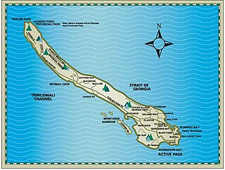
Active Pass is a strait separating Galiano Island in the north and Mayne Island in the south in the southern Gulf Islands, British Columbia, Canada. It connects the Trincomali Channel in the west and the Strait of Georgia in the east. The pass stretches 5.5 km from northeast to southwest with two roughly right-angle bends, one at each end.

Victoria Harbour is a harbour, seaport, and seaplane airport in the Canadian city of Victoria, British Columbia. It serves as a cruise ship and ferry destination for tourists and visitors to the city and Vancouver Island. It is both a port of entry and an airport of entry for general aviation. Historically it was a shipbuilding and commercial fishing centre. While the Inner Harbour is fully within the City of Victoria, separating the city's downtown on its east side from the Victoria West neighbourhood, the Upper Harbour serves as the boundary between the City of Victoria and the district municipality of Esquimalt. The inner reaches are also bordered by the district of Saanich and the town of View Royal. Victoria is a federal "public harbour" as defined by Transport Canada. Several port facilities in the harbour are overseen and developed by the Greater Victoria Harbour Authority, however the harbour master's position is with Transport Canada.

Parker Island is a roughly 400-acre (160 ha) island in the Southern Gulf Islands of British Columbia, Canada. It forms the western side of Montague Harbour, sheltering it from the strong wind gusts of Trincomali Channel. The island may be reached by floatplane, private boat, helicopter or water taxi; there is no public ferry service.

Portland Island is an island of the Southern Gulf Islands of the South Coast of British Columbia, Canada. It is located in the Salish Sea west of Moresby Island and off the south tip of Saltspring Island, adjacent to the main BC Ferries route just offshore from the terminal at Swartz Bay at the tip of the Saanich Peninsula. It was named after HMS Portland, the flagship of Rear-Admiral Fairfax Moresby, Commander in Chief of the Pacific Station 1850–1853.

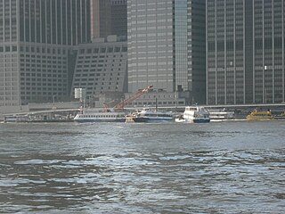
Pier 11/Wall Street is a pier providing slips to ferries and excursion boats on the East River in the Port of New York and New Jersey. It is located east of South Street and FDR Drive just south of Wall Street in Lower Manhattan, New York City. The ferry terminal has five landings, each with two berths, and is used by three privately owned companies.
Stuart Channel is a strait in the Gulf Islands region of the Gulf of Georgia, separating Vancouver Island on the west from Thetis, DeCourcy and Penelakut (Kuper) Islands on the east. Ladysmith Harbour and the town of Chemainus face onto it from Vancouver Island. It is crossed by a BC Ferries route serving Thetis and Penelakut Islands.


