Styggforsen

Last updated
Styggforsen
Styggforsen 2010.jpg
The upper cascade of Styggforsen waterfall
Styggforsen
Location Dalarna, Sweden
Coordinates 61°00′00″N15°11′00″E / 61.00000°N 15.18333°E / 61.00000; 15.18333
Total height36 metres (118 ft)
WatercourseStyggforsån

Styggforsen is a waterfall and a nature reserve located in Dalarna County, Sweden. It is part of the European Union-wide Natura 2000 network. [1]

Contents

Geography

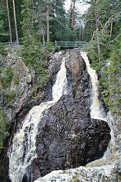
The waterfall is located in the village of Boda, 20 kilometres north of Rättvik. It lies at the eastern edge of the Siljan Ring, [2] a prehistoric impact crater formed 377 million years ago during the Devonian period. This crater was created when a bolide, estimated to be about 4 kilometres in diameter and traveling at around 100,000 kilometres per hour, struck the Earth's surface. [3] The impact caused a significant vertical realignment of the horizontal rock strata and created a bedrock depression, resulting in many of the geological features present today, such as Lake Siljan to the southwest and Styggforsen itself.

The Styggforsån river is interrupted by the 36-meter-high Styggforsen waterfall, which is composed of a column of Ordovician limestone. The waterfall's base meets a dike of brecciated quartz believed to predate the impact event. [4] This site is popular with tourists and features a circular path about one kilometre long that leads to a cave called Troll Hole. During the summer, a cafe is open, and there is an information centre nearby.

Flora and fauna

In 1979, a nature reserve of approximately 12 hectares was established around the waterfall, and in 2005, it was incorporated into the Natura 2000 network. [1] The area's moist climate supports a diverse range of lichens, mosses, and plants, including the rare orchid Epipactis atrorubens, [5] Additionally, it provides a habitat for many insect species, including Venusia cambrica , Hyloicus pinastri, and Epirrhoe alternata. [6] Within the nature reserve, picking flowers and any activities that could affect the environment are strictly prohibited.

Trivia

Ingmar Bergman's film, The Virgin Spring, used Styggforsen as one of its locations. [7]

Related Research Articles

<span class="mw-page-title-main">Impact crater</span> Circular depression in a solid astronomical body formed by the impact of a smaller object

An impact crater is a depression in the surface of a solid astronomical body formed by the hypervelocity impact of a smaller object. In contrast to volcanic craters, which result from explosion or internal collapse, impact craters typically have raised rims and floors that are lower in elevation than the surrounding terrain. Impact craters are typically circular, though they can be elliptical in shape or even irregular due to events such as landslides. Impact craters range in size from microscopic craters seen on lunar rocks returned by the Apollo Program to simple bowl-shaped depressions and vast, complex, multi-ringed impact basins. Meteor Crater is a well-known example of a small impact crater on Earth.

<span class="mw-page-title-main">Natura 2000</span> Network of protected areas

Natura 2000 is a network of nature protection areas in the territory of the European Union. It is made up of Special Areas of Conservation and Special Protection Areas designated under the Habitats Directive and the Birds Directive, respectively. The network includes both terrestrial and Marine Protected Areas.

<span class="mw-page-title-main">Chicxulub crater</span> Prehistoric impact crater in Mexico

The Chicxulub crater is an impact crater buried underneath the Yucatán Peninsula in Mexico. Its center is offshore, but the crater is named after the onshore community of Chicxulub Pueblo. It was formed slightly over 66 million years ago when an asteroid, about ten kilometers in diameter, struck Earth. The crater is estimated to be 200 kilometers in diameter and 20 kilometers in depth. It is believed to be the second largest impact structure on Earth, and the only one whose peak ring is intact and directly accessible for scientific research.

<span class="mw-page-title-main">Siljan (lake)</span> Lake in Sweden

Siljan, in Dalarna in central Sweden, is Sweden's seventh largest lake. The cumulative area of Siljan and the adjacent, smaller lakes Orsasjön and Insjön is 354 km2 (137 sq mi). Siljan reaches a maximum depth of 134 m (440 ft), and its surface is situated 161 m (528 ft) above sea level. This renders the lowest point of the basin at 27 metres (89 ft) above sea level. The largest town on its shore is Mora.

<span class="mw-page-title-main">Dalälven</span> River in Sweden

The Dal River is a river in central Sweden that flows from the north of Dalarna and runs into the sea in northern Uppland; it is commonly considered to be the southern border of Norrland, however only the last part correlates with Limes Norrlandicus. The northern part is split into two rivers: Österdalälven and Västerdalälven. The two connect in Djurås. It is over 520 kilometres (320 mi) long — the second longest river in Sweden, and has a hydropower potential of 1420 megawatts, of which 2/3 is utilized. The largest power plant is located at the Trängslet Dam. Dalälven has been significant historically as a raft transport route. Nedre Dalälven River Landscape, Sweden, covers 308,000 hectares (1,190 sq mi) with a mixture of wetlands, rivers, lakes, flood plains and productive forests. It includes Lake Hovran and Färnebofjärden Bay Ramsar site.

<span class="mw-page-title-main">Araguainha crater</span> Impact crater in Brazil

The Araguainha crater or Araguainha dome is an impact crater on the border of Mato Grosso and Goiás states, Brazil, between the villages of Araguainha and Ponte Branca. With a diameter of 40 kilometres (25 mi), it is the largest known impact crater in South America.

<span class="mw-page-title-main">Orsa, Sweden</span> Place in Dalarna, Sweden

Orsa is a locality and the seat of Orsa Municipality, Dalarna County, Sweden, with 5,308 inhabitants (2010). It is located in the northern part of lake Siljan, about 15 kilometres north of the town Mora. Inlandsbanan and European route E45 run through the town and the railroad Bollnäs-Orsa connects.

<span class="mw-page-title-main">Mora, Sweden</span> Place in Dalarna, Sweden

Mora is a locality and the seat of Mora Municipality in Dalarna County, Sweden, with 10,896 inhabitants in 2010.

<span class="mw-page-title-main">Archipelago Sea</span> Part of the Baltic Sea

The Archipelago Sea is a part of the Baltic Sea between the Gulf of Bothnia, the Gulf of Finland and the Sea of Åland, within Finnish territorial waters. By some definitions it contains the largest archipelago in the world by the number of islands, although many of the islands are very small and tightly clustered.

The Muogamarra Nature Reserve is a protected nature reserve that is located in the Sydney region of New South Wales, in eastern Australia. The 2,274-hectare (5,620-acre) reserve is situated in the northern edge of Sydney and lies between the suburb of Cowan to the south, and the Hawkesbury River to the north.

<span class="mw-page-title-main">Färnebofjärden National Park</span> Swedish national park

Färnebofjärden National Park is a Swedish national park traversed by the river Dalälven, about 140 km (87 mi) north of Stockholm. It covers 10,100 ha, of which 4,110 ha aquatic, on the frontier between the counties of Dalarna and Gävleborg.

<span class="mw-page-title-main">Siljan Ring</span> Impact structure in the country of Sweden

The Siljan Ring is a prehistoric impact structure in Dalarna, central Sweden. It is one of the 15 largest known impact structures on Earth and the largest in Europe, with a diameter of about 52 kilometres (32 mi). The impact that created the Siljan Ring occurred when a meteorite collided with the Earth's surface during the Devonian period. The exact timing of the impact has been estimated at 376.8 ± 1.7 Ma or at 377 ± 2 Ma. This impact has been proposed as a cause of the first Devonian extinction, the Kellwasser Event or Late Frasnian extinction, due to it being believed by some researchers to coincide around the time of the Kellwasser event at 376.1 Ma ± 1.6 Ma, although the timing of this extinction event has since been pushed forward to 371.93–371.78 Ma. The effects of the impact can clearly be seen in the bedrock in the area. The Cambrian, Ordovician and Silurian sedimentary rocks deformed by the impact are rich in fossils.

The Folkeslunda Limestone is a thin limestone and mudstone geologic formation of Sweden. The formation crops out on the island of Öland to the east of Kalmar, where Folkeslunda is located. Other exposures of the formation are in Dalarna, Jämtland and Östergötland. The Folkeslunda Limestone was deposited in an open marine environment with an estimated water depth of 150 to 200 metres in a eustatically transgressive phase.

<span class="mw-page-title-main">Hällingsåfallet</span> Nature reserve in Jämtland, Sweden

Hällingsåfallet is a waterfall and a nature reserve in Jämtland County in Sweden. It is part of the European Union-wide Natura 2000 network.

<span class="mw-page-title-main">Rogen Nature Reserve</span> Nature reserve in Jämtland, Sweden

Rogen Nature Reserve is a nature reserve in Jämtland County in Sweden. It is part of the EU-wide Natura 2000-network.

<span class="mw-page-title-main">Berge Virgin Forest Nature Reserve</span> Nature reserve in Sweden

Berge Virgin Forest Nature Reserve is a nature reserve in Jämtland County in Sweden. It is part of the EU-wide Natura 2000-network.

<span class="mw-page-title-main">Tandövala</span>

Tandövala is a nature reserve in Dalarna County, Sweden.

The Hummeln structure was confirmed, in 2015, as an impact crater in Småland province, Sweden. It is a 1.2 kilometres (0.75 mi) wide depression within Lake Hummeln and is estimated to have formed between 470 and 443 Ma ago, during the Ordovician.

In early 2018 there were eight known impact structures in Sweden. They range in age from 90 mya to 470 mya, and in diameter from 1 km to 52 km. Six of them are exposed, that is they are visible at the surface, in the natural landscape, although their nature and origin might need to be pointed out to the untrained layman.

References

  1. 1 2 "Styggforsen (SE0620088)". Natura 2000 . European Environment Agency . Retrieved 5 July 2015.
  2. Juhlin, Christopher; Sturkell, Erik; Ebbestad, Jan Ove R. (December 2012). "A new interpretation of the sedimentary cover in the western Siljan Ring area, central Sweden, based on seismic data". Tectonophysics. 580: 88–99. doi: 10.1016/j.tecto.2012.08.040 . hdl: 10037/4985 .
  3. Reimold, Wolf U.; Kelley, Simon P.; Sherlock, Sarah C. (April 2005). "Laser argon dating of melt breccias from the Siljan impact structure, Sweden: Implications for a possible relationship to Late Devonian extinction events". Meteoritics & Planetary Science. 40 (4): 591–607. doi: 10.1111/j.1945-5100.2005.tb00965.x .
  4. Lindström, Maurits; Schmitz, Birger (20 August 2008). "Palaeozoic impact craters" (PDF). www.iugs.org. pp. 22–23. Retrieved 4 July 2015.
  5. Bremer, Fredrika (1845). I Dalarna, Volume 7 (in Swedish). p. 149.
  6. Tutt, James William; Burr, Malcolm (1998). "List of species". The Entomologist's Record and Journal of Variation. 110: 61, 63–64.
  7. "The Virgin Spring". ingmarbergman.se. Retrieved 4 July 2015.