Suchomasty | |
|---|---|
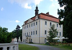
 Centre of Suchomasty | |
 Flag  Coat of arms | |
 Suchomasty Location in the Czech Republic | |
| Coordinates: 49°53′44″N14°3′24″E / 49.89556°N 14.05667°E | |
| Country | |
| Region | Central Bohemian |
| District | Beroun |
| First mentioned | 1088 |
| Area | |
• Total | 7.26 km2 (2.80 sq mi) |
| Elevation | 350 m (1,150 ft) |
| Population (2025-01-01) [1] | |
• Total | 545 |
| • Density | 75.1/km2 (194/sq mi) |
| Time zone | UTC+1 (CET) |
| • Summer (DST) | UTC+2 (CEST) |
| Postal codes | 267 01, 267 22 |
| Website | www |
Suchomasty is a municipality and village in Beroun District in the Central Bohemian Region of the Czech Republic. It has about 500 inhabitants.