Wan Chai is situated at the western part of Wan Chai District on the northern shore of Hong Kong Island, in Hong Kong. Its other boundaries are Canal Road to the east, Arsenal Street to the west and Bowen Road to the south. The area north of Gloucester Road is often referred to as Wan Chai North.

Hong Kong Island is an island in the southern part of Hong Kong. The island, known originally and on road signs simply as "Hong Kong", had a population of 1,289,500 and a population density of 16,390 per square kilometre (42,400/sq mi), as of 2023.

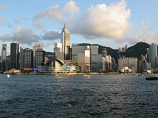
Central, also known as Central District, is the central business district of Hong Kong. It is located in the northeastern corner of the Central and Western District, on the north shore of Hong Kong Island, across Victoria Harbour from Tsim Sha Tsui, the southernmost point of Kowloon Peninsula. The area was the heart of Victoria City, although that name is rarely used today.

Repulse Bay or Tsin Shui Wan is a bay in the southern part of Hong Kong Island, located in the Southern District, Hong Kong. It is one of the most expensive residential areas in the world.

Stonecutters Island or Ngong Shuen Chau is a former island in Victoria Harbour, Hong Kong. Following land reclamation, it is now attached to the Kowloon Peninsula.

Victoria Harbour is a natural landform harbour in Hong Kong separating Hong Kong Island in the south from the Kowloon Peninsula to the north. The harbour's deep, sheltered waters and strategic location on South China Sea were instrumental in Hong Kong's establishment as a British colony in 1841 and its subsequent development as a trading centre.
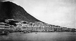
The City of Victoria, often called Victoria City or simply Victoria, was the de facto capital of Hong Kong during its time as a British dependent territory. It was initially named Queenstown but was soon known as Victoria. It was one of the first urban settlements in Hong Kong and its boundaries are recorded in the Laws of Hong Kong. All government bureaux and many key departments still have their head offices located within its limit.
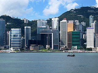
Admiralty is the eastern extension of the central business district on the Hong Kong Island of Hong Kong. It is located on the eastern end of the Central and Western District, bordered by Wan Chai to the east and Victoria Harbour to the north.

Admiral Sir Edward Belcher was a British naval officer, hydrographer, and explorer. Born in Nova Scotia, he was the great-grandson of Jonathan Belcher, who served as a colonial governor of Massachusetts, New Hampshire, and New Jersey.

Kellett Island is a former island of Victoria Harbour, off East Point in Hong Kong. It is now connected to Hong Kong Island at Causeway Bay following land reclamation in 1969.

Hong Kong (1800s–1930s) oversaw the founding of the new crown colony of Hong Kong under the British Empire. After the First Opium War, the territory was ceded by the Qing Empire to the United Kingdom of Great Britain and Ireland through Treaty of Nanjing (1842) and Convention of Peking (1860) in perpetuity. Together with additional land that was leased to the British under the Convention for the Extension of Hong Kong Territory (1898), Hong Kong became one of the first parts of East Asia to undergo industrialisation.

Green Island is an island off the northwest coast of Kennedy Town, Hong Kong Island, separated by the Sulphur Channel. A smaller island nearby to the east, uninhabited, is called Little Green Island (小青洲). Administratively, the two islands are part of Central and Western District.

Sai Wan, also known as Western district, or simply Western, is an area in Hong Kong Island, Hong Kong that corresponds to Sai Ying Pun, Shek Tong Tsui, Belcher Bay and Kennedy Town. However, Some Hong Kong people consider Kennedy Town as the only part of Sai Wan. It formed part of the City of Victoria. West Point, a former cape where major government structures in Sai Wan are close to, also used to refer to Sai Wan.

West Point was a point of land on Hong Kong Island, Hong Kong, south of Sulphur Channel. Its location is the shore off Pok Fu Lam Road and Queen's Road West in 1845, approximately the junction of Western Street and Des Voeux Road West near Western Police Station. This was the northernmost point on the western half of Hong Kong Island.

HMS Tamar was the name for the British Royal Navy's base in Hong Kong from 1897 to 1997. It took its name from HMS Tamar, a ship that was used as the base until replaced by buildings ashore.

Belcher's Street is a main street in Kennedy Town of Hong Kong. It connects east Victoria Road and joins west Queen's Road West. A small section in its west end built a turn around for Hong Kong Tramways.

HMS Sulphur was a 10-gun Hecla-class bomb vessel of the British Royal Navy, famous as one of the ships in which Edward Belcher explored the Pacific coast of the Americas.
Belcher Bay is a bay at Kennedy Town on the northwest shore of Hong Kong Island in Hong Kong. It is located east of Sulphur Channel. The bay is named after Edward Belcher, a Nova Scotia-born British naval officer who surveyed the surrounding water and land in the Victoria Harbour in 1841. Green Island and Little Green Island are located within the bay.

Stone Nullah Lane is a one-way street in Wan Chai, Hong Kong Island, Hong Kong. Named after the water channel that until 1959 ran down its middle, it stretches from Lung On Street to Queen's Road East. The street is noted for its historical landmarks, most notably the Blue House and Wan Chai Pak Tai Temple.
The Central and Western District located on northwestern part of Hong Kong Island is one of the 18 administrative districts of Hong Kong. It had a population of 243,266 in 2016. The district has the most educated residents with the second highest income and the third lowest population due to its relatively small size.

