
Kakata District is one of four districts located in Margibi County, Liberia. Kakata, the capital city of Margibi County, is located in the district.
Memory Island Provincial Park is a provincial park in British Columbia, Canada, located at the South end of Shawnigan Lake on Southern Vancouver Island.

The Northern Great Plain is a statistical region of Hungary. It is part of the Great Plain and North region. The Northern Great Plain includes the counties of Hajdú-Bihar, Jász-Nagykun-Szolnok, and Szabolcs-Szatmár-Bereg, with a total area of 17,749 km2 (6,853 sq mi) and a population of around 1.5 million.

A Barbanza is a comarca in the province of A Coruña, Galicia, Spain. Its capital is the municipality of Ribeira. The comarca contains four municipalities and 69,941 inhabitants in an area of 244.2 km². These municipalities are:

Mount Airy Township is one of fifteen townships in Surry County, North Carolina, United States. The township had a population of 24,828 according to the 2000 census.

Needmore is an unincorporated community in Marshall Township, Lawrence County, Indiana.

Fresh Pond is a small unincorporated community in El Dorado County, California. It is located 3 miles (4.8 km) east of Pollock Pines, at an elevation of 3606 feet. The ZIP code is 95726. The community is inside area code 530. It is nestled along Highway 50 and offers a convenient gas station by the road.
Mount Institute, 1,538 ft., is a peak located in Hawley, Massachusetts, just south of the village of Charlemont.

Piszczaty-Kończany is a village in the administrative district of Gmina Kobylin-Borzymy, within Wysokie Mazowieckie County, Podlaskie Voivodeship, in north-eastern Poland. It lies approximately 5 kilometres (3 mi) south-west of Kobylin-Borzymy, 17 km (11 mi) north-east of Wysokie Mazowieckie, and 38 km (24 mi) west of the regional capital Białystok.
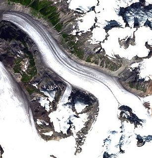
The Pashleth Glacier is a glacier south of the Machmell River and west of the Klinaklini Glacier in southwestern British Columbia, Canada.

Riggs Peak is a peak rising to 1690 m in Imeon Range on Smith Island, South Shetland Islands. Situated 2.38 km southwest of Neofit Peak, 5.4 km southwest of the summit Mount Foster, and 8.6 km northeast of Cape James. Overlooking Letnitsa Glacier to the south, and Gramada Glacier to the east. Bulgarian early mapping in 2009. Named after the American missionary and linguist Elias Riggs (1810–1901) who contributed greatly to the Bulgarian National Revival, and organized the first translation, printing and dissemination of the Bible in modern Bulgarian language.

Moscow Peak, also Moskva Peak or Pik Moskva, is a 6,785 m peak in the Peter I Range, western Pamir.

Utah State University–Tooele is a part of the Utah State University Regional Campuses and Distance Education system located in Tooele, Utah offering a number of Associate, bachelor's and master's degrees as well as certificate programs and a Doctor of Education program. Classes are taught online, face-to-face, and interactive broadcast. USU-Tooele has 10 full-time faculty members in addition to the several adjunct professors who collectively teach more than 300 classes. The campus provides academic advising and free tutoring.
Owl Trap is an unincorporated community in Gloucester County, in the U. S. state of Virginia.
The Fall River is a 14.1-mile-long (22.7 km) river in southern Vermont and northern Massachusetts, joining the Connecticut River just downstream from Turners Falls, Massachusetts.
Cove Creek is a stream in Beaver County and Millard County, Utah. It originates at the head of its canyon southeast of Cove Fort at 38°38′09″N112°29′34″W in Beaver County. It drains north down through the Tushar Mountains then turns west at the foot of Sulphur Peak running between the south end of the Pavant Range and the Tushar Mountains, past Cove Fort, from which it received its name. It then runs west past the north end of the Mineral Mountains to disappear into the sands of the desert at Beaver Bottoms.

Blue River is an unincorporated community in Polk Township, Washington County, in the U.S. state of Indiana.

Bolgarka is a selo in Alga District, Aktobe Region, west Kazakhstan. It lies at an altitude of 241 m (791 ft). Population: 480 ; 922.
Bennett Creek is tributary stream in Hidalgo County, New Mexico.


