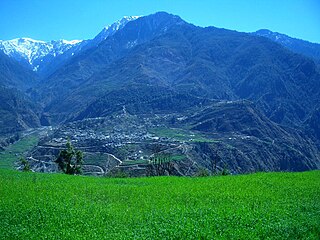
Bajura District, a part of Sudurpashchim Province, is one of the seventy-seven districts of Nepal. The district, with Martadi as its district headquarters, covers an area of 2,188 km2 (845 sq mi) and had a population of 108,781 in 2001 and 134,912 in 2011.
Ilam district is one of 14 districts of Koshi Province of eastern Nepal. It is a Hill district and covers 1,703 km2 (658 sq mi). The 2011 census counted 290,254 inhabitants. The municipality of Ilam is the district headquarters and is about 600 km (370 mi) from Kathmandu.

Sindhuli District, a part of the Bagmati Province, is one of the seventy-seven districts of Nepal, a landlocked country located in South Asia. The district, with Sindhulimadhi Kamalamai as its headquarters, covers an area of 2,491 km2 (962 sq mi). As per the 2011 census, Sindhuli District has a population of 296,192.

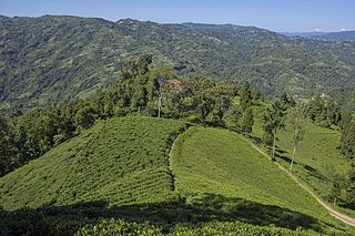
Ilam is one of four urban municipalities of Ilam District, which lies in the Mahabharata hilly range of Koshi Province, eastern Nepal. Ilam also acts as the headquarters of Ilam District. Being the largest producer region for Nepali tea, its tea farms are a major tourist attraction in Koshi Province. Ilam is also famous for its natural scenery and landscapes as well as its diverse agricultural economy which specializes in horticultural crop production.
Siraha is the headquarters and municipality of Siraha District, a part of Madhesh Province, Nepal. Siraha had a population of 28,442 according to the census of 2011. and a population of 82,531 as of 2015. The current population of Siraha municipality as of census 2022, is 96,543. It has a male population of 47,306 and female population of 49,237. The present mayor of Siraha Municipality is Dr. Nabin Kumar Yadav and Deputy Mayor is Babita Kumari Sah. Both assumed office on 25 May 2022. His predecessor mayor was Asheswor Yadav and the deputy mayor was Dr. Namita Yadav. Both assumed office on 25 September 2017 and their last working day was on 24 May 2022. The town is at 80 metres (260 ft) altitude, 29 kilometres (18 mi) ESE of Janakpur.
Sisautiya सिसौटिया is a small and most populated village in the southernmost part of Nepal commonly known as Madhesh or Terai. Sisautiya is 9 km north of the Indian border, 18 km south from Brahathawa municipality 9 km west from district headquarters Malangawa. It is located at 26°52'0N 85°34'0E with an altitude of 79 metres(262 feet) There is a customs checkpoint at the border crossing. It is part of the Sarlahi district and Province No. 2. It forms the main part of the Sisautiya village development committee. At the time of the 2011 Nepal census it had a population of 13,729 people living in 2259 individual households.

Bahrabise is an urban municipality located in Sindhupalchok District of Bagmati Province of Nepal.
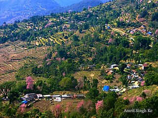
Barakot is a ward in Dasharathchanda municipality, in Baitadi District in Sudurpashchim Province of western Nepal. Earlier it was a village development committee (VDC). At the time of the 1991 Nepal census it had a population of 2,389 and had 462 houses in the village.
Dalchoki(Nepali: दलचोकी) is a village and former Village Development Committee that is now part of Konjyosom Rural Municipality in Province No. 3 of central Nepal. It is situated on the southern part of Lalitpur district, nearly 23 Kilometers from Patan, its district headquarters. This hilly region ranges from 1200 to 2300 meters from the sea level. At the time of the 1991 Nepal census it had a population of 1,066 in 193 individual households.
Rupakot is a Village Development Committee (VDC) in Gulmi District in the Lumbini Zone of central Nepal. Its headquarters is in Myal pokhara. It is located in about the center of Gulmi District. It is surrounded by hills. Its main religion is Hinduism. There are many temples like Chhatra Thaan, Shiddababa temple, Shiva Temple, Ram Temple, Debi deurali temple etc. The main sources of revenue for the village are agriculture and foreign employment. At the time of the 2001 Nepal census, it had a population of 3521 persons residing in 704 individual households. 76.48% of students attend school. The most populated parts of this VDC is Damuka, Sota & Ekle Pipal.
Danabari is a town and Village Development Committee in Ilam District in the Province No. 1 of eastern Nepal. At the time of the 2011 Nepal census it had a population of 14302 persons living in 1492 individual households.
Maipokhari is a town and Village Development Committee in Ilam District in Province No. 1 of eastern Nepal. At the 1991 Nepal census, it had a population of 4,348 persons in 931 individual households.
Sangrumba साङरुम्बा is a town and Village Development Committee in Ilam District in the Province No. 1 of eastern Nepal. At the time of the 1991 Nepal census it had a population of 4,607 persons living in 839 individual households. According to the VDC report of 2068 BS, the total population was 6,288 and the total number of households was 1,227, an average of 5.12 members per household.
Salyan is a town and Village Development Committee in Kaski District in the Gandaki Zone of northern-central Nepal. At the time of the 1991 Nepal census it had a population of 3,254 persons living in 665 individual households.
Sunkhani is a ward committee located in Kalinchowk Rural Municipality of Dolakha District in the Bagmati Province of north-eastern Nepal. Formally it was a Village Development Committee of Dolakha District. Sunkhani consists of two ward committees. The office of Kalinchowk Rural Municipality also lies in Sunkhani ward number 08.

Surunga is a trade center of Jhapa District. It is located in Kankai Municipality in Jhapa District in the Koshi Province of south-eastern Nepal. At the time of the 1991 Nepal census it had a population of 16,747 people living in 2996 individual households. Surunga is one of the rapidly developing towns of Jhapa district. It is situated on the bank of the Kankai River.
Beldandi is a rural municipality in Kanchanpur District in Sudurpashchim Province of southwestern Nepal named after the former Village Development Committee. At the time of the 1991 Nepal census the VDC had a population of 9301 people living in 1483 individual households. According to the Nepal census 2011 the municipality had 3022 individual households and a population of 21,959. In the north and west, Beldandi is surrounded by Suklaphatha national park. To the east lies Belauri Municipality. On the south, it borders India.
Amarapuri is a town in Gaidakot Municipality in Nawalpur District in the Lumbini Zone of southern Nepal. It became a municipality in May 2014 by merging the existing Mukundapur, Amarapuri, Gaidakot, Nawalparasi, VDCs. At the time of the 2011 Nepal census it had a population of 8,762 living in 1,979 households. Amarapuri has three high schools, the Shree Laxmi Higher Secondary School, Amar Jyoti Higher Secondary School and Amar English Higher Secondary Boarding School.
Shivasatakshi is a municipality in the southeastern part of Jhapa District in the Koshi Province of eastern Nepal. The new municipality was formed by merging four existing VDCs—Shivaganj, Satasidham, Dharampur, and Panchgachhi—on 2 Dec 2014. The office of the municipality is that of the former Satasidham village development committee (VDC).
Sandakpur is a rural municipality (gaunpalika) out of six rural municipality located in Ilam District of Province No. 1 of Nepal. There are a total of 10 municipalities in Ilam in which 4 are urban and 6 are rural.