
Rukwa Region(Mkoa wa Rukwa in Swahili) is one of Tanzania's 31 administrative regions The region covers a land area of 27,765 km2 (10,720 sq mi). The region is comparable in size to the combined land area of the nation state of Haiti. Rukwa Region is bordered to the north by Katavi Region, to the east by Songwe Region, to the south by the nation of Zambia and to the west by Lake Tanganyika, which forms a border between Tanzania and the Democratic Republic of the Congo. The regional capital is the municipality of Sumbawanga. According to the 2022 national census, the region had a population of 1,540,519.

Sumbawanga is a city located in western Tanzania. It is the capital of Rukwa Region and the municipal seat of Sumbawanga Urban District with postcode number 55100. The district had a population of approximately 303,986 based on the 2022 census. Sumbawanga lies in the territory of the Wafipa Fipa tribe and so many people speak Kifipa, as well as Kiswahili, the most widely used language of Tanzania. The name of the town literally translates as "throw away your witchcraft", thought to be a warning from local spiritual "healers" to any bringing in superstitions and practices relating to spiritual healers from other areas. Until the 1980s approximately, Sumbawanga was a place where many witch doctors were located. Though fewer in numbers, there are still some healers who practice both in town and in the surrounding smaller villages on the plateau. The town has the largest hospital in the region, Rukwa General Hospital, which is government funded, as well as the smaller Dr. Atiman Hospital administrated and run by the Catholic Diocese of Sumbawanga.
Moshi is one of the seven administrative districts of the Kilimanjaro Region of Tanzania. The district covers an area of 1,300 km2 (500 sq mi). The District is bordered to the north by the Rombo District, to the west by the Hai District, to the east by the Mwanga District and Kenya, and to the south by Simanjiro District of Manyara Region. The district also surrounds Moshi Municipal District on three sides. According to the 2012 census, the population of the Moshi District was 466,737. By 2022, the population had grown to 535,803.
Mpanda District is one of the five districts of the Katavi Region of Tanzania. Its administrative seat is the city of Mpanda. The district is bordered to the northwest by the Kigoma Region, to the northeast by the Tabora Region, to the east by the Mbeya Region, to the southeast by the Sumbawanga Urban District, to the southwest by the Nkasi District and to the west by Lake Tanganyika.

Nkasi District is one of the three districts of the Rukwa Region of Tanzania, with its headquarters in the village of Namanyere. It is bordered to the north by the Mpanda District of Katavi Region; to the east by the Sumbawanga District; to the south by the Sumbawanga Rural District and Zambia; and to the west by Lake Tanganyika across from the Democratic Republic of Congo.

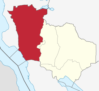
Sumbawanga Urban District is one of the four districts in the Rukwa Region of Tanzania. It is bordered to the north by Lake Rukwa, to the east by the Mbeya Region, to the south by the Sumbawanga Rural District and to the west by the Nkasi District. The district capital is Sumbawanga.

Chunya District is one of the seven districts of Mbeya Region, Tanzania. It is bordered to the north by Tabora Region, to the northeast by Singida Region, to the east by Mbarali District, to the south by Mbeya Rural District, and to the west by Songwe District.
Tunduma is a city in Songwe Region, Tanzania, on the border between Tanzania and Zambia. It has border posts for both the Tanzam Highway and the TAZARA railway linking the two countries. It is located 103 km southwest of Mbeya. It is also the junction for the tarmac road which runs via Sumbawanga through the remote far western districts of Tanzania to Kasulu and Kibondo in the north-west. According to the 2022 census, it has a population of 219,309. Tunduma can be the most famous border city within SADCC countries and it is informerly known as the gateway to East Africa with the neighbour country of Zambia. Once you are in Tunduma, you can enter the town of Nakonde, in Zambia either on foot or other means of transportation.
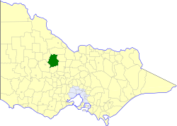
The Shire of Korong was a local government area about 75 kilometres (47 mi) west-northwest of Bendigo, in western Victoria, Australia. The shire covered an area of 238.5 square kilometres (92.1 sq mi), and existed from 1862 until 1995.

The following outline is provided as an overview of and topical guide to Tanzania:
Nkangamo is an administrative ward in Momba District, Songwe Region, Tanzania. As of the 2022 census, it has a total population of 16,804. According to the 2002 census, the ward was in the Mbozi District and had a total population of 8,122. A 400 kV transmission line is in the planning phase and would terminate within Tanzania around Nkangamo.
Lolkisale is an administrative ward in the Monduli district of the Arusha Region of Tanzania. According to the 2002 census, the ward has a total population of 10,179.
Malangali is a ward in the city of Sumbawanga in Rukwa Region, Tanzania. According to the 2002 census, the ward has a total population of 4,050.

Shelabolikhinsky District is an administrative and municipal district (raion), one of the fifty-nine in Altai Krai, Russia. It is located in the north of the krai. The area of the district is 2,510 square kilometers (970 sq mi). Its administrative center is the rural locality of Shelabolikha. Population: 13,678 (2010 Census); 15,818 (2002 Census); 15,535 (1989 Census). The population of Shelabolikha accounts for 29.3% of the district's total population.
Mpanda is a city in Katavi Region of Tanzania, East Africa with a postcode number 50100. It is the administrative centre of Katavi Region, Mpanda District and is itself one of the four districts of the region.

Kalambo District is one of the four districts of the Rukwa Region of Tanzania, East Africa. The administrative seat is in Matai. The Kalambo River flows through the district and its mouth on Lake Tanganyika is about 15 km south of the town of Kasanga.

Savanes District is one of fourteen administrative districts of Ivory Coast. The district is located in the northernmost part of the country. The capital of the district is Korhogo.
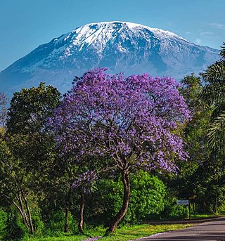
The Ufipa Plateau is a highland in southwestern Tanzania. It lies mostly in Rukwa Region, near the border with Zambia. The plateau is named for the Fipa people who inhabit it.
