
Oxfordshire is a ceremonial county in South East England. The county is bordered by Northamptonshire and Warwickshire to the north, Buckinghamshire to the east, Berkshire to the south, and Wiltshire and Gloucestershire to the west. The city of Oxford is the largest settlement and county town.
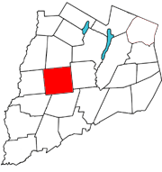
New Lisbon is a town in Otsego County, New York, United States. The population was 1,114 at the 2010 census.
Butlers Cross is a hamlet within the parish of Ellesborough, in Buckinghamshire, England. It is in the south of the parish, at the crossroads between the road from Ellesborough to Little Kimble, and the road from Terrick to the Chequers country house.

Ford is a hamlet in the parish of Dinton-with-Ford and Upton, in Buckinghamshire, England. It is located in the south eastern corner of the parish.
Widmer End is a hamlet in the parish of Hughenden, in Buckinghamshire, England.

Sykehouse is a village and civil parish in the City of Doncaster, South Yorkshire, England, on the border with the East Riding of Yorkshire. It was part of the West Riding of Yorkshire until 1974. It had a population of 438 in 2001, increasing to 515 at the 2011 Census.

Whiteway Colony is a residential community in the Cotswolds in the parish of Miserden near Stroud, Gloucestershire, United Kingdom. The community was founded in 1898 by Tolstoyans and today has no spare land available with over sixty homes and 120 colonists. At the beginning, private property was rejected and personal property shared; however, today the colonists' homes are privately owned and sold at market value. As the colony abandoned Tolstoy's philosophy it has been regarded by many, including Mohandas Gandhi who visited in 1909, as a failed Tolstoyan experiment.

The A417 is a main road in England, running from Streatley, Berkshire to Hope under Dinmore, Herefordshire. It is best known for its section between Cirencester and Gloucester where it has primary status and forms part of the link between the major settlements of Swindon and Gloucester.
Stonehouse is a town in the Stroud District of Gloucestershire in southwestern England.

Teddington is a village and parish in Gloucestershire, England.

Hawkesbury is a hamlet and civil parish in South Gloucestershire, England. The hamlet, consisting of a few cottages around a triangular green, lies west of Hawkesbury Upton, off the A46 road.

The A217 is a road in London and Surrey in England. It runs north–south. It runs from Kings Road in Fulham, London, crosses the Thames at Wandsworth Bridge, then passes through Wandsworth, Earlsfield, Summerstown, Tooting, Mitcham, Rosehill and Sutton Common in Sutton, then Cheam. Then, widened as a dual carriageway, comes Belmont, a suburban district built on a slope rising southward. On the North Downs in Surrey the road then skirts past Banstead and through its late 19th century offspring villages particularly Burgh Heath and Kingswood, Surrey. It then crosses the M25 motorway at Junction 8, then, returning to single carriageways, passes through the castle town of Reigate. It then cuts through the green buffer farmland of two rural villages and terminates at the road network at Gatwick Airport's northern perimeter.

Calcot Manor is a historic building in Calcot, three and a half miles west of Tetbury on A 4135 in Gloucestershire, England, near the junction of roads A46 and A4135. The original building was established in approximately 1300 AD by Henry of Kingswood as a tithe barn annex of Kingswood Abbey. The estate was expanded to include a 16th-century manor house and other buildings. Structures added from the Late Middle Ages to the mid-17th century include a chapel, granary, stables and other buildings. The buildings are all constructed from limestone; which are locally quarried stones that are typically flat and easily stacked for drystone wall purposes.
Withington is a Cotswold village and civil parish in Gloucestershire, England, about 7 miles (11 km) southeast of Cheltenham and 8 miles (13 km) north of Cirencester. The River Coln runs through the village. The parish includes the hamlets of Hilcot, Foxcote and Cassey Compton. The parish population taken at the 2011 census was 532.

Stanway House is a Jacobean manor house near the village of Stanway in Gloucestershire, England. The manor of Stanway was owned by Tewkesbury Abbey for 800 years, then for 500 years by the Tracy family and their descendants, the Earls of Wemyss and March.
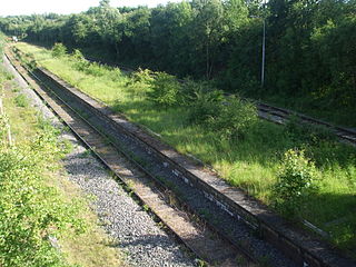
There are 22 disused railway stations on the Bristol to Exeter line between Bristol Temple Meads and Exeter St Davids. The line was completed in 1844 at which time the temporary terminus at Beambridge was closed. The most recent closure was Tiverton Junction which was replaced by a new station} on a different site in 1986. 12 of the disused stations have structures that can still be seen from passing trains.

Longborough is a village and civil parish 2.5 miles (4.0 km) north of the market town of Stow on the Wold, Gloucestershire. The parish population taken at the 2011 census was 471.

Donnington is a small village and civil parish in Gloucestershire, near the Roman Fosse Way in the Cotswold District Council area of south west England. It is situated on a hill a mile and a half north of Stow-on-the-Wold, of which until 1894 it formed a detached hamlet, so that the north transept in the parish church was reserved for the parish. There are fine views over the Evenlode valley.
Calvert was a railway station at Calvert, Buckinghamshire on the former Great Central Main Line between Manchester Piccadilly and London Marylebone. The station was opened in 1899 and closed to passengers in 1963 and goods in 1964.

Kingscote is a village and civil parish in the Cotswold district of Gloucestershire, England, set on the uplands near the south western edge of the Cotswold hills. It is situated about two miles (3 km) east of Uley, five miles (8 km) east of Dursley and four miles (6 km) west of Tetbury. The landscape is designated an Area of Outstanding Natural Beauty. The hamlet of Newington Bagpath lies to the west of the village; the parish lands extend near to the small village of Owlpen.

