
Lechlade is a town at the edge of the Cotswolds in Gloucestershire, England, 55 miles (89 km) south of Birmingham and 68 miles (109 km) west of London. It is the highest point at which the River Thames is navigable, although there is a right of navigation that continues south-west into Cricklade, in the neighbouring county of Wiltshire. The town is named after the River Leach that joins the Thames near the Trout Inn and St. John's Bridge.

Edington is a village and civil parish in Wiltshire, England, about 4 miles (6 km) east-northeast of Westbury. The village lies under the north slope of Salisbury Plain and the parish extends south onto the Plain. Its Grade I listed parish church was built for Edington Priory in the 14th century.

Easton Royal is a village in the civil parish of Easton in Wiltshire, England, about 3 miles (5 km) east of Pewsey and 5 miles (8 km) south of Marlborough. The village was the location of Easton Priory from 1234 to 1536. The village mistakenly gained the Royal suffix in 1838 and the name Easton Royal has been in general use since the 1850s.

Cricklade is a town and civil parish on the River Thames in north Wiltshire, England, midway between Swindon and Cirencester. It is the first downstream town on the Thames. The parish population at the 2011 census was 4,227.

Ampney Crucis is a village and civil parish in the Cotswolds, part of the Cotswold District of Gloucestershire, England.

Barnsley is a village and civil parish in the Cotswold district of Gloucestershire, England, 3.7 miles (6.0 km) northeast of Cirencester. It is 125 kilometres (78 mi) (geodesically) west of London.

Broadwell is a village and civil parish in the English county of Gloucestershire. It is about 1.5 miles (2.4 km) north of Stow-on-the-Wold, In the 2001 United Kingdom census, the parish had a population of 384. decreasing to 355 at the 2011 census.

Monkton Farleigh is a village and civil parish in west Wiltshire, England, on high ground 3 miles (5 km) northwest of Bradford-on-Avon, and a similar distance east of the city of Bath. The parish includes the hamlets of Farleigh Wick and Pinckney Green. In the west and northwest the parish is bounded by Somerset.

Ogbourne St Andrew is a civil parish and small village in Wiltshire, England, 2 miles (3.2 km) north of Marlborough. The parish is on the banks of the River Og and includes the hamlets of Ogbourne Maizey and Rockley.

Upavon is a rural village and civil parish in the county of Wiltshire, England. As its name suggests, it is on the upper portion of the River Avon which runs from north to south through the village. It is on the north edge of Salisbury Plain about 4 miles (6.4 km) south of Pewsey, 10 miles (16 km) southeast of the market town of Devizes, and 20 miles (32 km) north of the cathedral city of Salisbury. The A345 and A342 roads run through the village.
Maiden Bradley is a village in south-west Wiltshire, England, about 6 miles (10 km) south-west of Warminster and bordering the county of Somerset. The B3092 road between Frome and Mere forms the village street. Bradley House, the seat of the Duke of Somerset, is adjacent to the village.
Meysey Hampton is a village and civil parish in Gloucestershire, England, approximately 30 miles (48 km) to the south-east of Gloucester. It lies in the south of the Cotswolds, an Area of Outstanding Natural Beauty.
Cold Aston is a village and civil parish in Gloucestershire, England, approximately 18 miles (29 km) to the east of Gloucester. It lies in the Cotswolds, an Area of Outstanding Natural Beauty. In the 2011 census, the population was 255.

Manningford is a civil parish in Wiltshire, England. The parish includes the villages of Manningford Abbots, Manningford Bohune and Manningford Bruce, and the hamlet of Manningford Bohune Common, together known as the Manningfords.

Knook is a small village and civil parish in Wiltshire, England. The village lies to the north of the River Wylye at the edge of Salisbury Plain, about 4+1⁄2 miles (7 km) southeast of Warminster, close to the A36 road to Salisbury.
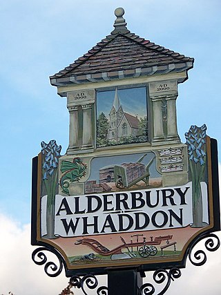
Alderbury is a village and civil parish in Wiltshire, England, in the south of the county around 3 miles (5 km) southeast of Salisbury.
Poulton Priory or the Priory of St Mary was a Gilbertine priory in Poulton, Gloucestershire, England. It was founded as a chantry chapel in 1337 by Sir Thomas Seymour and became a house of Gilbertine canons in 1350. From 1539, with the Dissolution of the Monasteries, the priory was used as the parish church for Poulton. It was demolished in 1873.

Elkstone is a village and civil parish in the English county of Gloucestershire. In the 2001 United Kingdom census, the parish had a population of 203, increasing to 248 at the 2011 census

North Newnton is a civil parish in Wiltshire, England, 2.5 miles (4.0 km) southwest of Pewsey. The parish is in the Vale of Pewsey which carries the upper section of the Salisbury Avon.

Highway is a hamlet and former civil parish, now in the parish of Hilmarton, in Wiltshire, England. The hamlet lies about 1+1⁄2 miles (2.4 km) southeast of Hilmarton village and 3+1⁄2 miles (6 km) northeast of the town of Calne.

