Sunol is an unincorporated area and census-designated place in Alameda County, California. Located in the Sunol Valley of the East Bay, the population was 913 at the 2010 census. It is best known as the location of the Sunol Water Temple and for its historic tourist railroad system, the Niles Canyon Railway.

Hetch Hetchy is a valley, a reservoir, and a water system in California in the United States. The glacial Hetch Hetchy Valley lies in the northwestern part of Yosemite National Park and is drained by the Tuolumne River. For thousands of years before the arrival of settlers from the United States in the 1850s, the valley was inhabited by Native Americans who practiced subsistence hunting-gathering. During the late 19th century, the valley was renowned for its natural beauty – often compared to that of Yosemite Valley – but also targeted for the development of water supply for irrigation and municipal interests. The controversy over damming Hetch Hetchy became mired in the political issues of the day. The law authorizing the dam passed Congress on December 7, 1913. In 1923, the O'Shaughnessy Dam was completed on the Tuolumne River, flooding the entire valley under the Hetch Hetchy Reservoir. The dam and reservoir are the centerpiece of the Hetch Hetchy Project, which in 1934 began to deliver water 167 miles (269 km) west to San Francisco and its client municipalities in the greater San Francisco Bay Area.

The Tuolumne River flows for 149 miles (240 km) through Central California, from the high Sierra Nevada to join the San Joaquin River in the Central Valley. Originating at over 8,000 feet (2,400 m) above sea level in Yosemite National Park, the Tuolumne drains a rugged watershed of 1,958 square miles (5,070 km2), carving a series of canyons through the western slope of the Sierra. While the upper Tuolumne is a fast-flowing mountain stream, the lower river crosses a broad, fertile and extensively cultivated alluvial plain. Like most other central California rivers, the Tuolumne is dammed multiple times for irrigation and the generation of hydroelectricity.
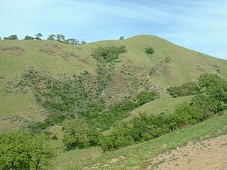
The Sunol Regional Wilderness is a regional park in Alameda County, the eastern San Francisco Bay Area, Northern California. It is located near the town of Sunol, south of Pleasanton and east of Fremont.
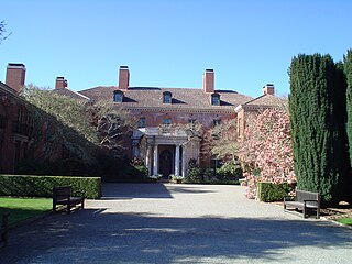
Filoli, also known as the Bourn-Roth Estate, is a country house set in 16 acres (6.5 ha) of formal gardens surrounded by a 654-acre (265 ha) estate, located in Woodside, California, about 25 miles (40 km) south of San Francisco, at the southern end of Crystal Springs Reservoir, on the eastern slope of the Santa Cruz Mountains. Now owned by the National Trust for Historic Preservation, Filoli is open to the public. The site is both a California Historical Landmark and listed on the National Register of Historic Places.

The San Francisco Public Utilities Commission (SFPUC) is a public agency of the City and County of San Francisco that provides water, wastewater, and electric power services to the city and an additional 1.9 million customers within three San Francisco Bay Area counties.

Niles Canyon is a canyon in the San Francisco Bay Area formed by Alameda Creek, known for its heritage railroad and silent movie history. The canyon is largely in an unincorporated area of Alameda County, while the western portion of the canyon lies within the city limits of Fremont and Union City. The stretch of State Route 84 known as Niles Canyon Road traverses the length of the canyon from the Niles district of Fremont to the unincorporated town of Sunol. Two railroads also follow the same route down the canyon from Sunol to Niles: the old Southern Pacific track along the north side, now the Niles Canyon Railway, and the newer Union Pacific track a little to the south. At the west end of the canyon are the ruins of the Vallejo Flour Mill, which dates to 1853.
The South Bay Aqueduct is an aqueduct located in the eastern part of the San Francisco Bay Area. It conveys water from the Sacramento-San Joaquin Delta through over forty miles of pipelines and canals. It begins in north-eastern Alameda County on the California Aqueduct's Bethany Reservoir serving as the forebay. The aqueduct flows along the eastern and southern edges of the Livermore Valley. Then it flows through a series of tunnels to an end in the foothills of eastern San Jose, 5 miles (8 km) from downtown San Jose, California.
Sunol Valley is located in Alameda County, California, United States. The small town of Sunol lies in the valley. It is largely rural, but is in proximity to the highly populated Bay Area suburbs of Fremont, Pleasanton, and Livermore.
The Raker Act was an act of the United States Congress that permitted building of the O'Shaughnessy Dam and flooding of Hetch Hetchy Valley in Yosemite National Park, California. It is named for John E. Raker, its chief sponsor. The Act, passed by Congress in 1913 during the Wilson administration, specified that because the source of the water and power was on public land, no private profit could be derived from the development. The plan for damming the valley was fought for years by John Muir. Construction of the dam was finished in 1923.

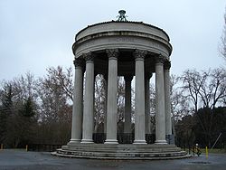
The Pulgas Water Temple is a stone structure in Redwood City, California, United States, designed by architect William G. Merchant. It was erected by the San Francisco Water Department to commemorate the 1934 completion of the Hetch Hetchy Aqueduct and is located at the aqueduct's terminus; originally water flowed through a vault under the temple itself, but new requirements for treatment require it to be diverted to a plant nearby. The name comes from Rancho de las Pulgas, an early Spanish land grant. Pulgas is the Spanish word for "fleas", which were encountered by early Spanish explorers of the area.

Alameda Creek is a large perennial stream in the San Francisco Bay Area. The creek runs for 45 miles (72 km) from a lake northeast of Packard Ridge to the eastern shore of San Francisco Bay by way of Niles Canyon and a flood control channel. Along its course, Alameda Creek provides wildlife habitat, water supply, a conduit for flood waters, opportunities for recreation, and a host of aesthetic and environmental values. The creek and three major reservoirs in the watershed are used as water supply by the San Francisco Public Utilities Commission, Alameda County Water District and Zone 7 Water Agency. Within the watershed can be found some of the highest peaks and tallest waterfall in the East Bay, over a dozen regional parks, and notable natural landmarks such as the cascades at Little Yosemite and the wildflower-strewn grasslands and oak savannahs of the Sunol Regional Wilderness. After an absence of half a century, ocean-run steelhead trout are able to return to Alameda Creek to mingle with remnant rainbow trout populations. Completion of a series of dam removal and fish passage projects, along with improved stream flows for cold-water fish and planned habitat restoration, enable steelhead trout and Chinook salmon to access up to 20 miles (32 km) of spawning and rearing habitat in Alameda Creek and its tributaries. The first juvenile trout migrating downstream from the upper watershed through lower Alameda Creek toward San Francisco Bay was detected and documented in April 2023.
Crystal Springs Reservoir is a pair of artificial lakes located in the northern Santa Cruz Mountains of San Mateo County, California, situated in the rift valley created by the San Andreas Fault just to the west of the cities of San Mateo and Hillsborough, and I-280. The lakes are part of the San Mateo Creek watershed.
Lake Del Valle is a storage reservoir located 10 miles (16 km) southeast of Livermore, in Alameda County, California. It is within Del Valle Regional Park.

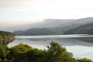
San Antonio Reservoir is located in Alameda County, California, about three miles east-southeast of Sunol. It was built in 1964 by the City and County of San Francisco. Formed by the James H. Turner Dam across San Antonio Creek not far above where it flows into Alameda Creek, its purpose is to store water from the Hetch Hetchy Aqueduct and local wells and watersheds. It has a capacity of 50,500 acre-feet (62,300,000 m3).

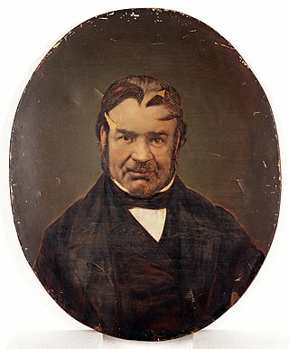
William Bowers Bourn II was an American entrepreneur and socialite. Bourn ran and controlled the Empire Mine and the San Francisco Gas Company, he was an investor in Spring Valley Water Company, and he led a merger to what later became Pacific Gas and Electric Company. Bourn II was the builder of many estates in California, including Filoli, the country estate in San Mateo County, California.
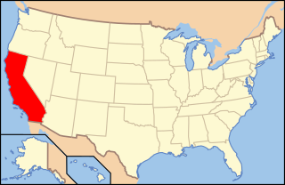
The environment of California describes results of human habitation of the American State of California.

Restore Hetch Hetchy is a US non-profit organization seeking to restore the Hetch Hetchy Valley in Yosemite National Park to its original condition.

O'Shaughnessy Dam is a 430-foot (131 m) high concrete arch-gravity dam in Tuolumne County, California, United States. It impounds the Tuolumne River, forming the Hetch Hetchy Reservoir at the lower end of Hetch Hetchy Valley in Yosemite National Park, about 160 miles (260 km) east of San Francisco. The dam and reservoir are the source for the Hetch Hetchy Aqueduct, which provides water for over two million people in San Francisco and other municipalities of the west Bay Area. The dam is named for engineer Michael O'Shaughnessy, who oversaw its construction.
Moccasin Dam is a small dam on Moccasin Creek in Tuolumne County, California, in the town of Moccasin, west of Yosemite. It holds the Moccasin Reservoir. The dam, reservoir and associated hydroelectric power plant are part of the Hetch Hetchy Project, which provide water and power to the city of San Francisco. The dam is located near the junction of Highway 120 and Highway 49.