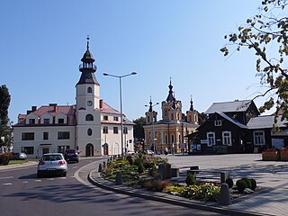
Tomaszów Lubelski is a town in south-eastern Poland with 19,365 inhabitants (2017). Situated in the Lublin Voivodeship, near Roztocze National Park, it is the capital of Tomaszów Lubelski County.

The Battle of Tomaszów Lubelski took place from 18 September to 20 September 1939 near the town of Tomaszów Lubelski. It was the second largest battle of the Invasion of Poland and also the largest tank battle of the campaign. It resulted in the surrender of Army Krakow on 20 September 1939.

Tomaszów County is a unit of territorial administration and local government (powiat) in Lublin Voivodeship, eastern Poland, on the border with Ukraine. It was established on January 1, 1999, as a result of the Polish local government reforms passed in 1998. Its administrative seat and largest town is Tomaszów Lubelski, which lies 107 kilometres (66 mi) south-east of the regional capital Lublin. The only other towns in the county are Tyszowce, lying 28 km (17 mi) north-east of Tomaszów, and Łaszczów, lying 25 km (16 mi) east of Tomaszów.
Gmina Tomaszów Lubelski is a rural gmina in Tomaszów Lubelski County, Lublin Voivodeship, in eastern Poland. Its seat is the town of Tomaszów Lubelski, although the town is not part of the territory of the gmina.
Bukowina is a village in the administrative district of Gmina Tomaszów Lubelski, within Tomaszów Lubelski County, Lublin Voivodeship, in eastern Poland.
Dolina is a village in the administrative district of Gmina Tomaszów Lubelski, within Tomaszów Lubelski County, Lublin Voivodeship, in eastern Poland.
Górno is a village in the administrative district of Gmina Tomaszów Lubelski, within Tomaszów Lubelski County, Lublin Voivodeship, in eastern Poland. It lies approximately 4 kilometres (2 mi) north of Tomaszów Lubelski and 105 km (65 mi) south-east of the regional capital Lublin.
Justynówka is a village in the administrative district of Gmina Tomaszów Lubelski, within Tomaszów Lubelski County, Lublin Voivodeship, in eastern Poland. It lies approximately 7 kilometres (4 mi) north-east of Tomaszów Lubelski and 107 km (66 mi) south-east of the regional capital Lublin.
Łaszczówka is a village in the administrative district of Gmina Tomaszów Lubelski, within Tomaszów Lubelski County, Lublin Voivodeship, in eastern Poland. It lies approximately 2 kilometres (1 mi) east of Tomaszów Lubelski and 108 km (67 mi) south-east of the regional capital Lublin.
Majdan Górny is a village in the administrative district of Gmina Tomaszów Lubelski, within Tomaszów Lubelski County, Lublin Voivodeship, in eastern Poland. It lies approximately 6 kilometres (4 mi) east of Tomaszów Lubelski and 108 km (67 mi) south-east of the regional capital Lublin.
Majdanek is a village in the administrative district of Gmina Tomaszów Lubelski, within Tomaszów Lubelski County, Lublin Voivodeship, in eastern Poland. It lies approximately 4 kilometres (2 mi) north-east of Tomaszów Lubelski and 108 km (67 mi) south-east of the regional capital Lublin.
Nowa Wieś is a village in the administrative district of Gmina Tomaszów Lubelski, within Tomaszów Lubelski County, Lublin Voivodeship, in eastern Poland. It lies approximately 9 kilometres (6 mi) east of Tomaszów Lubelski and 110 km (68 mi) south-east of the regional capital Lublin.
Pasieki is a village in the administrative district of Gmina Tomaszów Lubelski, within Tomaszów Lubelski County, Lublin Voivodeship, in eastern Poland. It lies approximately 6 kilometres (4 mi) west of Tomaszów Lubelski and 106 km (66 mi) south-east of the regional capital Lublin.
Podhorce is a village in the administrative district of Gmina Tomaszów Lubelski, within Tomaszów Lubelski County, Lublin Voivodeship, in eastern Poland. It lies approximately 10 kilometres (6 mi) north-east of Tomaszów Lubelski and 109 km (68 mi) south-east of the regional capital Lublin.
Rabinówka is a village in the administrative district of Gmina Tomaszów Lubelski, within Tomaszów Lubelski County, Lublin Voivodeship, in eastern Poland. It lies approximately 4 kilometres (2 mi) south-west of Tomaszów Lubelski and 107 km (66 mi) south-east of the regional capital Lublin.

Rogóźno is a village in the administrative district of Gmina Tomaszów Lubelski, within Tomaszów Lubelski County, Lublin Voivodeship, in eastern Poland. It lies approximately 3 kilometres (2 mi) north-west of Tomaszów Lubelski and 104 km (65 mi) south-east of the regional capital Lublin.
Szarowola is a village in the administrative district of Gmina Tomaszów Lubelski, within Tomaszów Lubelski County, Lublin Voivodeship, in eastern Poland. It lies approximately 7 kilometres (4 mi) north-west of Tomaszów Lubelski and 101 km (63 mi) south-east of the regional capital Lublin.
Sznury is a settlement in the administrative district of Gmina Tomaszów Lubelski, within Tomaszów Lubelski County, Lublin Voivodeship, in eastern Poland. It lies approximately 3 kilometres (2 mi) east of Tomaszów Lubelski and 108 km (67 mi) south-east of the regional capital Lublin.
Wieprzowe Jezioro is a village in the administrative district of Gmina Tomaszów Lubelski, within Tomaszów Lubelski County, Lublin Voivodeship, in eastern Poland. It lies approximately 6 kilometres (4 mi) north of Tomaszów Lubelski and 103 km (64 mi) south-east of the regional capital Lublin.
Zamiany is a village in the administrative district of Gmina Tomaszów Lubelski, within Tomaszów Lubelski County, Lublin Voivodeship, in eastern Poland. It lies approximately 6 kilometres (4 mi) north-west of Tomaszów Lubelski and 101 km (63 mi) south-east of the regional capital Lublin.
