Bishkek, formerly Pishpek and Frunze, is the capital and largest city of Kyrgyzstan. Bishkek is also the administrative centre of the Chuy Region. The region surrounds the city, although the city itself is not part of the region but rather a region-level unit of Kyrgyzstan. It is also near the Kazakhstan–Kyrgyzstan border. Its population was 1,074,075 in 2021.

Kyrgyzstan, sometimes called Kirghizia, officially the Kyrgyz Republic, is a mountainous landlocked country in Central Asia. Kyrgyzstan is bordered by Kazakhstan to the north, Uzbekistan to the west, Tajikistan to the south, and China to the east. Its capital and largest city is Bishkek. Ethnic Kyrgyz make up the majority of the country's six million people, followed by significant minorities of Uzbeks and Russians. The Kyrgyz language is closely related to other Turkic languages, although Russian remains spoken and is a co-official language. Ninety percent of Kyrgyzstan's population are Muslim, with the majority of its population following Sunni Islam. In addition to its Turkic origins, Kyrgyz culture bears elements of Iranic, Mongolian and Russian influence.

The Tian Shan, also known as the Tengri Tagh or Tengir-Too, meaning the Mountains of Heaven or the Heavenly Mountain, is a large system of mountain ranges located in Central Asia. The highest peak in the Tian Shan is Jengish Chokusu, at 7,439 metres (24,406 ft) high. Its lowest point is the Turpan Depression, which is 154 m (505 ft) below sea level.

Osh is the second-largest city in Kyrgyzstan, located in the Fergana Valley in the south of the country and often referred to as the "capital of the south". It is the oldest city in the country and has served as the administrative center of Osh Region since 1939. The city has an ethnically mixed population of 322,164 in 2021, comprising Uzbeks, Kyrgyz, Russians, Tajiks, and other smaller ethnic groups. It is about 5 km from the Uzbekistan border.
The president of Kyrgyzstan officially the president of the Kyrgyz Republic, is the head of state and the head of government of the Kyrgyz Republic. The president directs the executive branch of the national government and is the commander-in-chief of the Kyrgyz military. The president also heads the National Security Council.

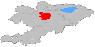
Chuy Region is the northernmost region (oblast) of the Kyrgyz Republic. This region surrounds the national capital of Kyrgyzstan, Bishkek. It is bounded on the north by Kazakhstan, and clockwise, Issyk-Kul Region, Naryn Region, Jalal-Abad Region, and Talas Region. Its administrative center is Bishkek. Its total area is 19,895 km2 (7,682 sq mi). The resident population of the region was 974,984 as of January 2021. The region has sizeable Russian and Dungan minorities.

Osh Region is a region (oblast) of Kyrgyzstan. Its capital is Osh, which is not part of the region. It is bounded by (clockwise) Jalal-Abad Region, Naryn Region, China (Xinjiang), Tajikistan, Batken Region, and Uzbekistan. Its total area is 28,934 km2 (11,171 sq mi). The resident population of the region was 1,391,649 as of January 2021. The region has a sizeable Uzbek minority.

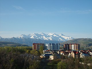
Kara-Balta is a city and municipality on the Kara-Balta River, in Chuy Region, Kyrgyzstan, the capital of Jayyl District. It was founded in 1825 under the Kokand Khanate, and received city status in 1975 under the Soviets. Its population was 48,278 in 2021.

The Kyrgyz Soviet Socialist Republic, also commonly known as the Kyrgyzstan and Soviet Kyrgyzstan in the Kyrgyz language and as Kirghizia and Soviet Kirghizia in the Russian language, was one of the constituent republics of the Soviet Union (USSR) from 1936 to 1991.

Women in Kyrgyzstan traditionally had assigned roles, although only the religious elite sequestered women as was done in other Muslim societies. Rural inhabitants continue the traditional Siberian tribal practice of bride kidnapping. Bride kidnapping, known as ala kachuu, girls as young as 12 years old are kidnapped for forced marriage, by being captured and carried away by groups of men or even relatives who, through violence or deception, take the girl to the abductor's family who forces and coerces the young woman to accept the illegal marriage. In most cases, the young woman is raped immediately in the name of marriage.[8]

Toktogul is a district of Jalal-Abad Region in western Kyrgyzstan. The administrative seat lies at Toktogul. Its area is 7,815 square kilometres (3,017 sq mi), and its resident population was 103,310 in 2021.
Jumgal is a district of Naryn Region in central Kyrgyzstan. The administrative seat lies at Chaek. Its area is 4,803 square kilometres (1,854 sq mi), and its resident population was 44,866 in 2021. It is a mountainous district. Its main rivers are the Kökömeren and its tributaries Jumgal, Suusamyr and Batysh Karakol.

The Kyrgyz Ala-Too also known as Kyrgyz Alatau, Kyrgyz Range, and Alexander Range is a large range in the North Tien-Shan. It stretches for a total length of 454 km from the west-end of Issyk-Kul to the town Taraz in Kazakhstan. It runs in the east–west direction, separating Chuy Valley from Kochkor Valley, Suusamyr Valley, and Talas Valley. Talas Ala-Too Range adjoins the Kyrgyz Ala-Too in vicinity of Töö Ashuu Pass. The western part of Kyrgyz Ala-Too serves as a natural border between Kyrgyzstan and Kazakhstan.
The Protected areas of Kyrgyzstan are regulated by the law on specially protected natural areas of 2 May 2011, last modified on 2 June 2018. In total, they cover 14,761.216 km2 (5,699.337 sq mi) and account for 7.38% of the country's total area. The first protected area in Kyrgyzstan (Issyk-Kul) was established in 1948. According to the Government Decree on Priorities of Conservation of Biological Diversity and the relevant Action Plan for 2014-2024 the target area for the protected areas in Kyrgyzstan is 10 percent of the country’s area by 2024.
Suusamyr Too is a mountain range in internal Tian Shan in Kyrgyzstan. It separates Suusamyr Valley and Toluk Saragat Valley. The length of the range is 126 km, and height up to 4048m. It is composed of granite, and schist of lower Paleozoic.
The Kökömeren is a right tributary of the Naryn located in Chuy Region and Naryn Region of Kyrgyzstan. It is formed by the confluence of the rivers Suusamyr and Batysh Karakol. It is 199 kilometres (124 mi) long, and has a drainage basin of 10,400 square kilometres (4,000 sq mi), with an average discharge of 80.3 cubic metres per second (2,840 cu ft/s). It possesses significant hydro-power potential. In June 2011, China and Kyrgyzstan signed a protocol of intent to begin construction of Kökömeren River chain of power plants in 2012. Whitewater rafting and fishing are popular tourist activities on the Kökömeren.
The Suusamyr is a river in Jayyl District of Chuy Region of Kyrgyzstan. It forms the Kökömeren where it meets with Batysh Karakol. Starting at Ala-Bel Pass, it flows eastwards along Suusamyr Valley. The Suusamyr is 90 kilometres (56 mi) long, and has a drainage basin of 2,410 square kilometres (930 sq mi).
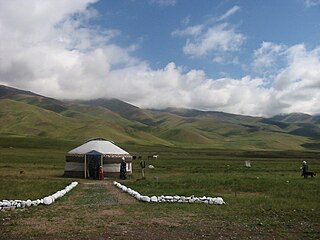
Suusamyr Valley lies at 2,000-2,500 meters above the sea level between Suusamyr Too and Kyrgyz Ala-Too ranges of Tian Shan mountains in Central Asia. Suusamyr River flows through it. The valley is predominantly used as "alpine summer pastures full of herbs and wild flowers – carpeting the valley floor in many colours." The area of the valley is 4,300 km2 (1,700 sq mi).
Suusamyr is a village in the southern part of the Jayyl District of Chuy Region of Kyrgyzstan. Its population was 3,468 in 2021. It is situated in the Suusamyr Valley, on the northern bank of the river Suusamyr.

State awards of the Kyrgyz Republic include the orders, decorations, and medals in Kyrgyzstan. They consist of military and civil decorations that are bestowed by various agencies of the government.
