
The Chu is a river in Northern Kyrgyzstan and Southern Kazakhstan. Of its total length of 1,067 kilometres (663 mi), the first 115 kilometres are in Kyrgyzstan, then for 221 kilometres the river is the border between Kyrgyzstan and Kazakhstan and the last 731 kilometres are in Kazakhstan. It is one of the longest rivers in Kyrgyzstan and in Kazakhstan. It has a drainage basin of 62,500 square kilometres (24,100 sq mi).
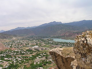
Balykchy is a town at the western end of Lake Issyk-Kul in Kyrgyzstan, at an elevation of about 1,900 metres. Its area is 38 square kilometres (15 sq mi), and its resident population was 42,875 in 2021. A major industrial and transport centre during the Soviet era, it lost most of its economic base after the collapse of the Soviet Union and the closure of virtually all of its industrial facilities.
Jalal-Abad Region, also known as Jalalabat, is a region (oblast) of Kyrgyzstan. Its capital is the city of the same name, Jalal-Abad. It is surrounded by Talas Region, Chuy Region, Naryn Region, Osh Region, and Uzbekistan. Jalal-Abad Region was established on 21 November 1939. On 27 January 1959 it became a part of Osh Region, but regained its old status as a region on 14 December 1990. Its total area is 32,418 km2 (12,517 sq mi). The resident population of the region was 1,260,617 as of January 2021. The region has a sizeable Uzbek minority.

Chatyr-Köl is an endorheic alpine lake in the Tian Shan mountains in At-Bashy District of Naryn Province, Kyrgyzstan; it lies in the lower part of Chatyr-Köl Depression near the Torugart Pass border crossing into China. The name of the lake means “Celestial Lake” in Kyrgyz.

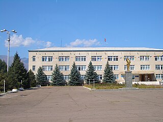
Kochkor is a large village in northern Naryn Region of Kyrgyzstan. It is the administrative centre of Kochkor District. The village was established in 1909 as Stolypino and renamed to Kochkor in 1917. Altitude 1,800 m. Its population was 11,373 in 2021. It is on the main A365 highway from Torugart Pass (China) north to Bishkek. About 7 km west A367 branches west toward Jalal-Abad Region and the Ferghana Valley. About 25 km northeast along the highway is the Orto-Tokoy reservoir and about 45 km northeast is Balykchy on Lake Issyk Kul. The village is a base for excursions into the high country and tourist infrastructure is fairly well developed. There is a regional museum.

Kochkor is a district of Naryn Region in northern-central Kyrgyzstan. The administrative seat lies at Kochkor. Its area is 5,868 km2 (2,266 sq mi), and its resident population was 67,363 in 2021.
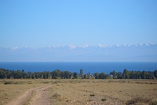
The Terskey Ala-Too is a mountain range in the Tian Shan mountains in Kyrgyzstan. It stretches south and southeast of Lake Issyk Kul, from the river Joon Aryk near Kochkor in the west to the far northeastern part of Kyrgyzstan. The length of the range is 354 km and the highest peak is Karakol Peak. Another high peak is Boris Yeltsin Peak.
The Kichi Ak-Suu Forest Reserve is located in the Anan'yevo rural community, Issyk-Kul District, Issyk-Kul Region, Kyrgyzstan. Established in 1977, it covers 100 hectares on the south slopes of the Küngöy Ala-Too Range. Its purpose is conservation of natural forests composed of Short-needled Schrenk's spruce.
The Tüp Botanical Reserve is located in Tüp District, Issyk-Kul Region, Kyrgyzstan. It was established in 1975 with a purpose of conservation of Savin Juniper. The botanical reserve occupies 100 hectares. Among other flora species inhabiting the reserve are willow, barberry, Caragana, etc.
The Ming-Kush Botanical Reserve is located in Jumgal District of Naryn Region of Kyrgyzstan. It was established in 1984 with a purpose of conservation of Ammopiptanthus nanus. The botanical reserve occupies 76.7 hectares.
The Kochkor is a river in Kochkor District of Naryn Province of Kyrgyzstan. It is formed by confluence of Karakol and Seok rivers. The river is 45 kilometres (28 mi) long, the basin area 2,590 square kilometres (1,000 sq mi), and the average annual discharge 12.6 cubic metres per second (440 cu ft/s). The Chu is formed by the confluence of Kochkor and Joon Aryk near the village Kochkor.

Orto-Tokoy Reservoir or Ortotokoy Reservoir (Kyrgyz: Ортотокой суу сактагычы), is a reservoir of the Chu River, located in Kochkor District of Naryn Region of Kyrgyzstan. It has a surface area of 24 km 2 and a maximum volume of 470 × 106 meters 3.

Mantysh is a village in the Kochkor District of Naryn Region of Kyrgyzstan. It is the center of Kara-Suu rural community. Its population was 1,393 in 2021.
The On-Archa is a river in Naryn District of Naryn Region of Kyrgyzstan. It is a right tributary of the river Naryn. The length of the river is 75 km, watershed - 1570 km2, and annual average flow rate - 9.92 m3/s.

The Joon Aryk is a river in Kochkor District of Naryn Province of Kyrgyzstan. It is formed by confluence of Kara-Kujur and Telek rivers. It is 34.8 kilometres (21.6 mi) long, and has a drainage basin of 1,340 square kilometres (520 sq mi). Average annual discharge - 11.4 cubic meters per second. The Chu is formed by the confluence of Kochkor and Joon Aryk near the village Kochkor.
Teploklyuchenka Game Reserve is a protected area in Ak-Suu District, Issyk-Kul Region of Kyrgyzstan. It was established in 1958 on the north slope of Teskey Ala-Too in the Arashan river basin with a purpose of conservation of game animals and protection of natural mountain forests. The reserve covers 32,200 hectares.
The Baydamtal Botanical Reserve is located in Tong District of Issyk-Kul Region of Kyrgyzstan. It is situated in the Boom Gorge along the river Chu, between Kök-Moynok-1 and the river Baydamtal. It was established in 1975 with a purpose of conservation of Nitraria schoberi L., Nitraria sibirica Pall., and Halimodendron halodendron Pall. Vegetation in the reserve is sparse. The botanical reserve occupies 20 hectares. Among other flora species inhabiting the reserve are Artemisia tianschanica, Festuca valesiaca Schleich. ex Gaudin, Agropyron cristatum (L.) Gaertn., Astragalus albertii Bunge, etc.
Tüp Game Reserve is a protected area in Tüp District of Issyk-Kul Region of Kyrgyzstan. It is situated on the north side of the Teskey Alatoo mountain range, in the basin of the rivers Tüp and Karkyra. Its purpose is to protect roe deer, boar, and Cervus elaphus. Established in 1976, the reserve occupies 15,000 hectares.
Kölükök is a mountain lake in the Naryn Region of Kyrgyzstan.
Tengdik is a village in Naryn Region of Kyrgyzstan. It is part of the Kochkor District and the Kochkor rural community. Its population was 5,052 in 2021.
