
Moseley is a suburb of south Birmingham, England, three miles south of the city centre. The area is a popular cosmopolitan residential location and leisure destination, with a number of bars and restaurants. The area also has a number of boutiques and other independent retailers.

Smethwick is an industrial town in Sandwell, West Midlands, England, historically in Staffordshire. It lies four miles west of Birmingham city centre.

Sutton Coldfield or the Royal Town of Sutton Coldfield, known locally as Sutton, is a town and civil parish in the City of Birmingham, West Midlands, England. The town lies around 8 miles northeast of Birmingham city centre, 9 miles south of Lichfield, 7 miles southwest of Tamworth and 7 miles east of Walsall. Sutton Coldfield and its surrounding suburbs are governed under Birmingham City Council for local government purposes but the town has its own town council which governs the town and its surrounding areas by running local services and electing a mayor to the council.

The River Cole is a 25 miles (40 km) river in the English Midlands. It rises on the lower slopes of Forhill, one of the south-western ramparts of the Birmingham Plateau, at Red Hill and flows south before flowing largely north-east across the plateau to enter the River Blythe below Coleshill, near Ladywalk, shortly before the Blythe meets the Tame. This then joins the Trent, whose waters reach the North Sea via the Humber Estuary. Its source is very near the main watershed of Midland England : tributaries are few and very short except in the lower reaches, so the Cole is only a small stream.

Harborne is an area of south-west Birmingham, England. It is one of the most affluent areas of the Midlands, three miles southwest from Birmingham city centre. It is a Birmingham City Council ward in the formal district and in the parliamentary constituency of Birmingham Edgbaston.
Hall Green is an area in southeast Birmingham, England, synonymous with the B28 postcode. It is also a council constituency, managed by its own district committee. Historically it lay within the county of Worcestershire.

Kings Norton, alternatively King's Norton, is an area of Birmingham, England. Historically in Worcestershire, it is also a Birmingham City Council ward within the Government of Birmingham, England. The district lies 6.5 miles south-southwest of Birmingham city centre and is within 1.5 miles of the north Worcestershire border.
Billesley is a ward within the council constituency and parliamentary constituency of Selly Oak, Birmingham, England. It is 7 kilometres (4 mi) south of the city centre and includes the area of Billesley and much of Yardley Wood as well as the Hollybank Road area of Kings Heath. It is contiguous with the Birmingham wards of Highter's Heath on the south-west, Brandwood and Kings Heath on the west, Moseley on the north and Hall Green South on the east. To the south-east is the Shirley West ward of Solihull.
Stirchley is in south-west Birmingham, England.

Moseley Bog and Joy's Wood Local Nature Reserve, formerly The Dell, is a Local Nature Reserve in the Moseley area of Birmingham, England, with an area of about 12 ha.

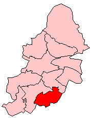
Birmingham Selly Oak is a constituency in the West Midlands, represented in the House of Commons of the UK Parliament since 2010 by Steve McCabe of the Labour Party.

The Shire Country Park is a country park in the south of Birmingham, England, taking its name from Tolkien's The Shire.
Cotteridge is an area of Birmingham, England and part of the Bournville ward. It is about 4 miles (6.4 km) miles south of Birmingham city centre. It has a shopping centre with a mixture of local shops, eateries and national brands.

Billesley Common is a recreational area of public open space in South Birmingham, England. It is situated along the Yardley Wood Road, between the suburbs of Moseley and Yardley Wood.

Birmingham Moseley Rugby Club is an English rugby union club, based in Birmingham, that compete in the third tier of English rugby. They were historically the premier rugby club in Birmingham, reaching the final of the John Player Cup three times in the late 1970s and early 1980s. They originally played at the Reddings, but after attempting to keep up with the transition to professional rugby, the club ran into financial difficulties and were forced to sell their 125-year home to property developers. An unsuccessful five-year spell based at the University of Birmingham followed, during which time they were relegated to National Division Two. In 2005 the club moved to its new home at Billesley Common, and were promoted to National Division One in 2006. In 2009 they won their first cup in 27 years beating Leeds 23–18 in the final of the National Trophy at Twickenham. On the weekend starting 15 April 2016; defeat to Bristol, combined with results elsewhere during the same weekend, confirmed Moseley's relegation to National League 1 for the 2016-17 season.

The Birmingham Baths Committee was an organisation responsible for the provision and maintenance of public swimming and bathing facilities. Birmingham City Council funded, constructed and ran bathing facilities throughout the city. The movement to develop baths and wash houses in Britain had its impetus with the rapid urbanisation of the Industrial Revolution, which was felt acutely in Birmingham, one of England's powerhouses.
Rubery is a village in the Bromsgrove district of Worcestershire. Part of the village also forms a southern suburb of Birmingham, England. The village is 9 miles (14 km) from Birmingham city centre.
Selly Park is a residential suburban district in south-west Birmingham, England. The suburb of Selly Park is located between the Bristol Road (A38) and the Pershore Road (A441).

Brandwood End Cemetery is a cemetery located in the Brandwood ward of Birmingham, England.


