
The Stratford-upon-Avon Canal is a canal in the south Midlands of England. The canal, which was built between 1793 and 1816, runs for 25.5 miles (41.0 km) in total, and consists of two sections. The dividing line is at Kingswood Junction, which gives access to the Grand Union Canal. Following acquisition by a railway company in 1856, it gradually declined, the southern section being un-navigable by 1945, and the northern section little better.

The River Rea is a small river which passes through Birmingham, England. It is the river on which Birmingham was founded by the Beorma tribe in the 7th century.
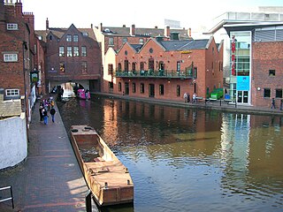
Birmingham Canal Navigations (BCN) is a network of canals connecting Birmingham, Wolverhampton, and the eastern part of the Black Country. The BCN is connected to the rest of the English canal system at several junctions.
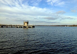
Chasewater is a reservoir located in the parish of Burntwood and the district of Lichfield in Staffordshire, England. Originally known as Norton Pool and Cannock Chase Reservoir, it was created as a canal feeder reservoir in 1797. The reservoir was created to directly supply the Wyrley and Essington Canal and maintain levels in the 160-mile (260 km) Birmingham Canal Network. During a period of great industrial growth in the Black Country region the maintenance of water levels in canal infrastructure was essential and Chasewater was in great demand. As canals became less essential for transport of goods during the mid-20th century, the reservoir diversified and became a popular public amenity with activities such as water-skiing, sailing, wakeboarding and cycling. Chasewater is the third largest reservoir by volume in the county of Staffordshire and the largest canal feeder reservoir in the West Midlands.

Selly Oak is an industrial and residential area in south-west Birmingham, England. The area gives its name to Selly Oak ward and includes the neighbourhoods of: Bournbrook, Selly Park, and Ten Acres. The adjoining wards of Edgbaston and Harborne are to the north of the Bourn Brook, which was the former county boundary, and to the south are Weoley, and Bournville. A district committee serves the four wards of Selly Oak, Billesley, Bournville and Brandwood. The same wards form the Birmingham Selly Oak constituency, represented by Steve McCabe (Labour). Selly Oak is connected to Birmingham by the Pershore Road (A441) and the Bristol Road (A38). The Worcester and Birmingham Canal and the Birmingham Cross-City Railway Line run across the Local District Centre.

The Worcester and Birmingham Canal is a canal linking Birmingham and Worcester in England. It starts in Worcester, as an 'offshoot' of the River Severn and ends in Gas Street Basin in Birmingham. It is 29 miles (47 km) long. There are 58 locks in total on the canal, including the 30 Tardebigge Locks, one of the largest lock flights in Europe. The canal climbs 428 feet (130 m) from Worcester to Birmingham.

Bartley Reservoir is a reservoir for drinking water in Birmingham, England, operated by Severn Trent Water. It covers 460,000 square metres (5,000,000 sq ft).
Stirchley is in the south west of Birmingham, England.

The Droitwich Canal is a synthesis of two canals in Worcestershire, England; the Droitwich Barge Canal and the Droitwich Junction Canal. The Barge Canal is a broad canal which opened in 1771 linking Droitwich Spa to the River Severn at Hawford Mill, Claines. The Droitwich Junction Canal is a narrow canal, opened in 1854, which linked Droitwich to the Worcester and Birmingham Canal. Both were built to carry salt, and were abandoned in 1939. They have been the subject of a restoration plan since 1973, and the Barge Canal was officially reopened in 2010, while the Junction Canal reopened in July 2011. Following the opening of the canal, ownership transferred to the newly created Canal and River Trust
The Warwickshire ring is a connected series of canals forming a circuit around the West Midlands area of England. The ring is formed from the Coventry Canal, the Oxford Canal, the Grand Union Canal, the Stratford-upon-Avon Canal and the Birmingham and Fazeley Canal. It is a popular route with tourists due to its circular route and mixture of urban and rural landscapes.

The Bittell Reservoirs are located in Worcestershire between Barnt Green to the south and the Birmingham district of Longbridge to the north. They consist of the Upper and Lower reservoir. They were built to feed the Worcester and Birmingham Canal, which was finished in the 1790s, however, the reservoir was not completed until 1837. The 'Upper' reservoir is to ensure that the level of the canal is kept sufficiently high, even in times of drought. The 'Lower' reservoir(s) are compensatory reservoirs to ensure that the local area does not become parched in dry times.

Edgbaston Reservoir, originally known as Rotton Park Reservoir and referred to in some early maps as Rock Pool Reservoir, is a canal feeder reservoir in Birmingham, England., maintained by the Canal & River Trust. It is situated close to Birmingham City Centre and is a Site of Importance for Nature Conservation.
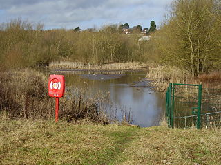
Wychall Reservoir, is a canal compensation reservoir in the Kings Norton district of Birmingham, England.
The Tame Valley Canal is a relatively late (1844) canal in the West Midlands of England. It forms part of the Birmingham Canal Navigations. It takes its name from the roughly-parallel River Tame.

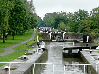
Tardebigge Locks or the Tardebigge Flight is the longest flight of locks in the UK, comprising 30 narrow locks on a two-and-a-quarter-mile (3.6 km) stretch of the Worcester and Birmingham Canal at Tardebigge, Worcestershire. It raises the waterway 220 feet (67 m), and lies between the Tardebigge tunnel to the North and the Stoke Prior flight of six narrow locks to the South. The Tardebigge Engine House is also on this stretch.
Kings Norton Junction is the name of the canal junction where the Stratford-upon-Avon Canal terminates and meets the Worcester and Birmingham Canal at Kings Norton, Birmingham, England.

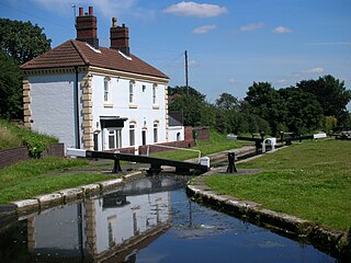
Kings Norton Stop Lock is a Grade II* listed building at Kings Norton Junction on the Stratford-upon-Avon Canal near its junction with the Worcester and Birmingham Canal. It is the only guillotine-gated stop-lock on a canal.
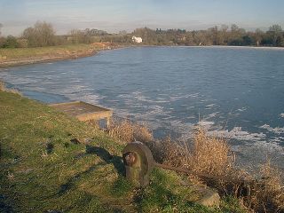
Tardebigge Lake is a large feeder reservoir, about 25 acres (100,000 m2) in size, built to supply water for the famous flight of locks running from Tardebigge towards Worcester, on the Worcester and Birmingham Canal. It is maintained by the Canal and River Trust and still supplies water to the canal system. The lake is up to 40-foot (12 m) deep at the dam end, shelving off to around 15 feet (4.6 m) at the inlet end.
The Birmingham West Suburban Railway was a suburban railway built by the Midland Railway company. Opened in stages between 1876 and 1885, it allowed both the opening of development of central southwest suburban Birmingham south into Worcestershire and the by-passing of railway traffic via the Birmingham and Gloucester Railway into central Birmingham. Today, it forms a major section of the Cross-City Line, running from Lichfield to Redditch. It also forms an important part of the Cross Country Route.

Knypersley Reservoir is a canal feeder reservoir near Biddulph in Staffordshire. It is located south-east of Biddulph and named after the local Knypersley area. The reservoir was built in 1827 to supply water to the Caldon Canal, along with two others at Stanley Pool and Rudyard Lake.


