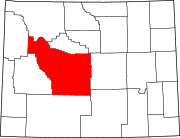
Sweetwater County is a county in southwestern Wyoming, United States. As of the 2010 United States Census, the population was 43,806. Its county seat is Green River. By area, it is the largest county in Wyoming. Its southern boundary line abuts the north lines of the states of Colorado and Utah.

Fremont County is a county in the U.S. state of Wyoming. As of the 2010 United States Census, the population was 40,123. Its county seat is Lander. The county was founded in 1884 and is named for John C. Frémont, a general, explorer, and politician. It is roughly the size of the state of Vermont.

Green River is a city in and the county seat of Sweetwater County, Wyoming, United States, in the southwestern part of the state. The population was 12,515 at the 2010 census.
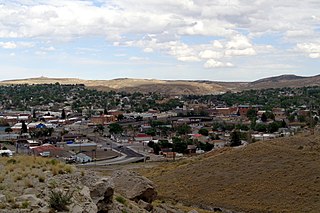
Rock Springs is a city in Sweetwater County, Wyoming, United States. The population was 23,036 at the 2010 census, making it the fifth most populated city in the state of Wyoming, and the most populous city in Sweetwater County. Rock Springs is the principal city of the Rock Springs micropolitan statistical area, which has a population of 37,975. Rock Springs is known as the Home of 56 Nationalities because of the influx of immigrants from all over the world who came to work in the coal mines that supplied the fuel to power the steam engines of the Union Pacific Railroad. The city's rich cultural heritage is celebrated each summer on International Day, a festival where the foods, costumes, and traditions of residents' ancestors are recreated and enjoyed at Bunning Park in downtown Rock Springs.

South Pass is the collective term for two mountain passes on the American Continental Divide, in the Rocky Mountains in southwestern Wyoming. It lies in a broad high region, 35 miles (56 km) wide, between the nearly 14,000 ft (4,300 m) Wind River Range to the north and the over 8,500 ft (2,600 m) Oregon Buttes and arid, saline near-impassible Great Divide Basin to the south. The Pass lies in southwestern Fremont County, approximately 35 miles (56 km) SSW of Lander.

The North Platte River is a major tributary of the Platte River and is approximately 716 miles (1,152 km) long, counting its many curves. In a straight line, it travels about 550 miles (890 km), along its course through the U.S. states of Colorado, Wyoming, and Nebraska.

The Sweetwater River is a 238-mile (383 km) long tributary of the North Platte River, in the U.S. state of Wyoming. As a part of the Mississippi River system, its waters eventually reach the Gulf of Mexico.

Fontenelle Reservoir is an artificial reservoir located in southwest Wyoming. It lies almost entirely within Lincoln County, although the east end of the Fontenelle Dam and a tiny portion of the reservoir are actually in northwestern Sweetwater County. Impounded by Fontenelle Dam, the reservoir acts primarily as a storage reservoir for the U.S. Bureau of Reclamation's Colorado River Storage Project, retaining Wyoming water in the state as a means of asserting Wyoming's water rights, with a secondary purpose of power generation. Water from Fontenelle Reservoir is used in local industries such as mining and power generation. Although initially projected to provide irrigation water for agriculture, the irrigation component was downgraded after difficulties with efficient irrigation in Wyoming's high semi-desert became apparent.

The Rock Springs massacre, also known as the Rock Springs Riot, occurred on September 2, 1885, in the present-day United States city of Rock Springs in Sweetwater County, Wyoming. The riot, and resulting massacre of immigrant Chinese miners by white immigrant miners, was the result of racial prejudice toward the Chinese miners, who were perceived to be taking jobs from the white miners. The Union Pacific Coal Department found it economically beneficial to give preference in hiring to Chinese miners, who were willing to work for lower wages than their white counterparts, angering the white miners. When the rioting ended, at least 28 Chinese miners were dead and 15 were injured. Rioters burned 78 Chinese homes, resulting in approximately US$150,000 in property damage.
Interstate 80 (I-80) is a part of the Interstate Highway System that runs from San Francisco to Teaneck, New Jersey. In Wyoming, the Interstate Highway runs 402.780 miles (648.212 km) from the Utah state line near Evanston east to the Nebraska state line in Pine Bluffs. I-80 connects Cheyenne, Wyoming's capital and largest city, with several smaller cities along the southern tier of Wyoming, including Evanston, Green River, Rock Springs, Rawlins, and Laramie. The highway also connects those cities with Salt Lake City to the west and Omaha to the east. In Cheyenne, I-80 intersects I-25 and has Wyoming's only auxiliary Interstate, I-180. The Interstate runs concurrently with U.S. Route 30 for most of their courses in Wyoming. I-80 also has shorter concurrencies with US 189 near Evanston, US 191 near Rock Springs, and US 287 and Wyoming Highway 789 near Rawlins. The Interstate has business loops through all six cities along its course as well as a loop serving Fort Bridger and Lyman east of Evanston.
Wyoming Highway 789 (WYO 789) is a 407-mile-long (655 km) state highway in the U.S. state of Wyoming. WYO 789 travels south-to-north from the Colorado state line to the Montana state line. For most of its length, it is concurrent with other routes. It was the path of a formerly-proposed U.S. Route 789 that was cancelled.
Blairtown is an unincorporated community in Sweetwater County, Wyoming, United States, located near Rock Springs. This town was actually a mining area before it became a town. It was started by the Blair Brothers back in the 1860s. It has its own park and is located near a set of Union Pacific Railroad.

The path followed by the Oregon Trail, California Trail and Mormon Trail spans 400 miles (640 km) through the U.S. state of Wyoming. The trail entered from Nebraska on the eastern border of the state near the present day town of Torrington and exited on the western border near the towns of Cokeville and Afton. An estimated 350,000 to 400,000 settlers traveled on the trail through Wyoming between 1841 and 1868. All three trails follow the same path through most of the state. The Mormon Trail splits at Fort Bridger and enters Utah, while the Oregon and California Trails continue to Idaho.
Wyoming Highway 370 (WYO 370) is a 4.63-mile-long (7.45 km) unmarked state highway that runs east of Rock Springs, Wyoming from exit 111 of Interstate 80 (I-80) and U.S. Route 30 to the Rock Springs - Sweetwater County Airport.

The former U.S. Post Office-Green River is a Classical Revival architecture building designed by James Wetmore and Thomas Hyrum in Green River, Wyoming that was built in 1931. It was built under the Elliot Act, a pre-New Deal economic recovery plan. In 1967, the building was repurposed and is now Sweetwater County Historical Museum. It was listed on the National Register of Historic Places in 1997. Its 1997 listing included alternative name Trudel's Restaurante.

The 1996 United States presidential election in Wyoming took place on November 5, 1996, as part of the 1996 United States presidential election. Voters chose three representatives, or electors to the Electoral College, who voted for president and vice president.

Solar power in Wyoming has the potential to generate 72 million MWh/yr. Wyoming used 12 million MWh in 1999. Wyoming is one of the country's windiest states and has the potential to generate 883 million MWh/yr from wind power. Solar and wind power tend to complement each other, with more solar power available in summer and during the day, and more wind power available at night and during the winter. Net metering is available to all consumers generating up to 25 kW. IREC best practices, based on experience, recommends no limits to net metering, individual or aggregate, and perpetual roll over of kWh credits. Installing a 5 kW solar array could cost $20,000 but is expected to pay for itself in 15 years, and go on to return a $15,166 profit over its expected 25 year life.
The 1988 United States presidential election in Wyoming took place on November 8, 1988. All 50 states and the District of Columbia, were part of the 1988 United States presidential election. State voters chose three electors to the Electoral College, which selected the president and vice president.

The 1972 United States presidential election in Wyoming took place on November 7, 1972. All 50 states and the District of Columbia were part of the 1972 United States presidential election. State voters chose three electors to the Electoral College, who voted for president and vice president.