Dadeldhura district, a part of Sudurpashchim Province, is one of the seventy-seven districts of Nepal. The district, with Dadeldhura as its district headquarters, covers an area of 1,538 km2 (594 sq mi) and had a population of 126,162 in 2001 and 142,094 in 2011.

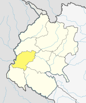
Dolpa District, is a district, located in Karnali Province of Nepal, It is one of the seventy-seven districts of Nepal and one of ten district of Karnali. The district, with Dunai as its district headquarters, covers an area of 7,889 km2 (3,046 sq mi) and has a population (2011) of 36,700. Dolpa is the largest district of Nepal.
Kanchanpur District, a part of Sudurpashchim Province in the Terai plain, is one of seventy seven districts of Nepal. The district, with Bhimdatta as its district headquarters, covers an area of 1,610 square kilometres (620 sq mi) and had a population of 134,868 in 2001 and 171,304 in 2011. It is located in south-western of Nepal. It is bordered by Kailali district in the east, Dadeldhura district in the north and with India in the south and west.

Mugu District, a part of Karnali Province, is one of the seventy-seven districts of Nepal. The district, with Gamgadhi as its district headquarters, covers an area of 3,535 km2 (1,365 sq mi) and had a population (2011) of 55,286. Mugu is known for being both the most remote district in Nepal, as well as the least developed.

Gadariya is a village development committee in Kailali District in Sudurpashchim Province of western Nepal. At the time of the 1991 Nepal census it had a population of 7355 living in 726 individual households. It has a main school named "Shree Janta Higher Secondary school."which is established in 2014 B.S. It has also a beautiful lake which name is Koilahee taal, and it is second biggest lake of Sudurpaschimanchal.

Myanglung is a municipality and the district headquarters of Terhathum District of Province No. 1 in eastern Nepal. The municipality is situated at an elevation of about 1500 metres above sea level. Myanglung was converted into a municipality from a village development committee on 18 May 2014, merging the existing village development committees of Myanglung, Piple, Jirikhimti, Ambung, Sabla and Tamphula. According to the census of 2011 the total population of Myanglung is 19,659 including five VDCs.

A Village Development Committee (VDC) in Nepal was the lower administrative part of its Ministry of Federal Affairs and Local Development. Each district had several VDCs, similar to municipalities but with greater public-government interaction and administration. There were 3,157 village development committees in Nepal. Each VDC was further divided into several wards depending on the population of the district, the average being nine wards.
The 1991 Nepal census was a widespread national census conducted by the Nepal Central Bureau of Statistics.
Mulpani is a village and former Village Development Committee that is now part of Kageshwari-Manohara Municipality in Kathmandu District in Province No. 3 of central Nepal. Mulpani was previously known as Bhaimal, meaning "no fear". At the time of the 1991 Nepal census it had a population of 4,718 living in 843 households. The main occupation of the people living in this village is agriculture. Mulpani is surrounded by Bagmati and Manohara river. Mulpani is famous for the Nepal's biggest International Cricket Ground, known as Mulpani Cricket Stadium, which is under construction. In the recent years, Mulpani has seen much change in its infrastructure and people as well. The main occupation in Mulpani was agriculture but now employment is more diverse.
Johang is a Village Development Committee VDC in Gulmi District in the Lumbini Zone of Western Nepal. At the time of the 2011 Nepal census it had a population of about 10000 living in 1509 individual households.
Gobardiha is a village of Gadawa Village Council in Dang Deukhuri District in Lumbini Province of south-western Nepal. At the time of the 2011 Nepal census it had a population of 15,322 where total female population was 7991 and male population was 7331 and2,873 individual households.

Saimarang is a town and Village Development Committee in Kaski District in the Gandaki Province of Western Nepal. At the time of the 2011 Nepal census it had a population of 1,171 persons living in 309 individual households. Saimarang owns a famous Temple Bhagawati Temple and hill known as Lamtari there is a famous Devi tample called Lamtari Mai which is in front of Pokhara Valley. We can see the Annapurna Himalayan range at the back and Begnash, Rupa and Fewa lake in the front. Also there are several adventures such as caves, rocky hills. Local people in Warchowk and Togi are working hard to make the Saimarang VDC a good place for Adventurous Tourism. The people there are very helpful.
Bidyapur is a village development committee in Surkhet District in Karnali Province of mid-western Nepal. At the time of the 1991 Nepal census it had a population of 4053 people living in 707 individual households.
Rara is a village development committee (VDC) in Mugu District in the Karnali Zone of north-western Nepal. At the time of the 1991 Nepal census, it had a population of 930, living in 199 individual households.
Kalimati Rampur is a village development committee in Salyan District in the Rapti Zone of western-central Nepal. At the time of the 1991 Nepal census it had a population of 2635.
Korbang Jhimpe is a village development committee in Salyan District in the Rapti Zone of western-central Nepal. At the time of the 2001 Nepal census it had a population of 636. According to the 2011 Nepal census Korbang Jhimpe had a population of 6,183.
Talawang is a village development committee in Rolpa District in the Rapti Zone of mid-western development region of north-eastern Nepal. At the time of the 2011 Nepal census it had a population of 5180 people living in 1048 individual households.
Nepal conducted a widespread national census in 2011 by the Nepal Central Bureau of Statistics. Working with the 58 municipalities and the 3915 Village Development Committees at a district level, they recorded data from all the municipalities and villages of each district. The data included statistics on population size, households, sex and age distribution, place of birth, residence characteristics, literacy, marital status, religion, language spoken, caste/ethnic group, economically active population, education, number of children, employment status, and occupation.

Bhanu is a municipality of Tanahun District in Gandaki Zone of western Nepal. The municipality was established on 19 September 2015 by merging the existing Bhanu village development committee or VDC, Barbhanjyang VDCs, Rupakot (VDC), Tanahunsur Village Development Committee, Purkot VDC, Mirlung VDC, Satiswara VDC, Risti VDC, Basantapur VDC and Chok Chisapani VDC. The center of the municipality is established in former VDC Office of Bhanu. After merging the population of all of the VDCs, it had a total population of 46,179 according to 2011 Nepal census. After the government decision the number of municipalities has reached 217 in Nepal. Nepali poet Bhanubhakta Acharya was born in Bhanu Municipality. It was named after him.
Tripurasundari is an urban municipality located in Dolpa District of Karnali Province of Nepal.

