São Bento, Maranhão

Last updated
São Bento, Maranhão
Municipality

ANB SB.JPG

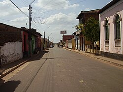
Avenida Newton Bello, São Bento
Maranhao Municip SaoBento.svg
Location in Maranhão
CountryFlag of Brazil.svg  Brazil
Region Nordeste
State Maranhão
Mesoregion Norte Maranhense
Time zone UTC -3

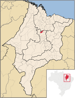
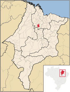
São Bento, Maranhão is a municipality in the state of Maranhão in the Northeast region of Brazil. [1] [2] [3] [4]

Municipalities of Brazil administrative division of the states in Brazil

The municipalities of Brazil are administrative divisions of the Brazilian states. At present, Brazil has 5,570 municipalities, making the average municipality population 34,361. The average state in Brazil has 214 municipalities. Roraima is the least subdivided state, with 15 municipalities, while Minas Gerais is the most subdivided state, with 853.

States of Brazil administrative entity of Brazil

The Federative Republic of Brazil is a union of 27 Federative Units : 26 states and one federal district. The states are generally based on historical, conventional borders which have developed over time. The Federal District cannot be divided into municipalities, according to the Brazilian Constitution, the Federal District assumes the same constitutional and legal powers, attributions and obligations of the states and municipalities, instead, it is divided by administrative regions.

Maranhão State of Brazil

Maranhão is a northeastern state of Brazil. To the north lies the Atlantic Ocean. Maranhão is neighboured by the states of Piauí, Tocantins and Pará. The people of Maranhão have a distinctive accent inside the common Northeastern Brazilian dialect. Maranhão is described in books such as The Land of the Palm Trees by Gonçalves Dias and Casa de Pensão by Aluísio Azevedo.

The municipality contains a small part of the Baixada Maranhense Environmental Protection Area, a 1,775,035.6 hectares (4,386,208 acres) sustainable use conservation unit created in 1991 that has been a Ramsar Site since 2000. [5]

Baixada Maranhense Environmental Protection Area

The Baixada Maranhense Environmental Protection Area is an environmental protection area in the state of Maranhão, Brazil. It includes large areas of wetlands, and was designated a Ramsar site in 2000. The traditional population lives in the area, but human activities are regulated in an effort to preserve the environment.

See also

Related Research Articles

Lago Verde, Maranhão Municipality in Nordeste, Brazil

Lago Verde, Maranhão is a municipality in the state of Maranhão in the Northeast region of Brazil.

Olho dÁgua das Cunhãs Municipality in Nordeste, Brazil

Olho d'Água das Cunhãs is a municipality in the state of Maranhão in the Northeast region of Brazil.

São Mateus do Maranhão Municipality in Nordeste, Brazil

São Mateus do Maranhão is a municipality in the state of Maranhão in the Northeast region of Brazil.

Anajatuba Municipality in Nordeste, Brazil

Anajatuba is a municipality in the state of Maranhão in the Northeast region of Brazil.

Arari Municipality in Nordeste, Brazil

Arari is a municipality in the state of Maranhão in the Northeast region of Brazil.

Conceição do Lago-Açu Municipality in Nordeste, Brazil

Conceição do Lago-Açu is a municipality in the state of Maranhão in the Northeast region of Brazil.

Olinda Nova do Maranhão Municipality in Nordeste, Brazil

Olinda Nova do Maranhão is a municipality in the state of Maranhão in the Northeast region of Brazil.

Peri Mirim Municipality in Nordeste, Brazil

Peri Mirim is a municipality in the state of Maranhão in the Northeast region of Brazil.

São João Batista, Maranhão Municipality in Nordeste, Brazil

São João Batista, Maranhão is a municipality in the state of Maranhão in the Northeast region of Brazil.

Vitória do Mearim Municipality in Nordeste, Brazil

Vitória do Mearim is a municipality in the state of Maranhão in the Northeast region of Brazil.

Matões do Norte Municipality in Nordeste, Brazil

Matões do Norte is a municipality in the state of Maranhão in the Northeast region of Brazil.

Bacurituba Municipality in Nordeste, Brazil

Bacurituba is a municipality in the state of Maranhão in the Northeast region of Brazil.

Bequimão Municipality in Nordeste, Brazil

Bequimão is a municipality in the state of Maranhão in the Northeast region of Brazil.

Cajapió Municipality in Nordeste, Brazil

Cajapió is a municipality in the state of Maranhão in the Northeast region of Brazil.

Central do Maranhão Municipality in Nordeste, Brazil

Central do Maranhão is a municipality in the state of Maranhão in the Northeast region of Brazil.

Guimarães, Maranhão Municipality in Nordeste, Brazil

Guimarães is a municipality in the state of Maranhão in the Northeast region of Brazil. It was founded as New Guimarães in 1758.

Mirinzal Municipality in Nordeste, Brazil

Mirinzal is a municipality in the state of Maranhão in the Northeast region of Brazil.

Porto Rico do Maranhão Municipality in Nordeste, Brazil

Porto Rico do Maranhão is a municipality in the state of Maranhão in the Northeast region of Brazil.

Bacabeira Municipality in Nordeste, Brazil

Bacabeira is a municipality in the state of Maranhão in the Northeast region of Brazil.

Santa Rita, Maranhão Municipality in Nordeste, Brazil

Santa Rita, Maranhão is a municipality in the state of Maranhão in the Northeast region of Brazil.

References

  1. "Divisão Territorial do Brasil" (in Portuguese). Divisão Territorial do Brasil e Limites Territoriais, Instituto Brasileiro de Geografia e Estatística (IBGE). July 1, 2008. Retrieved December 17, 2009.
  2. "Estimativas da população para 1º de julho de 2009" (PDF) (in Portuguese). Estimativas de População, Instituto Brasileiro de Geografia e Estatística (IBGE). August 14, 2009. Retrieved December 17, 2009.
  3. "Ranking decrescente do IDH-M dos municípios do Brasil" (in Portuguese). Atlas do Desenvolvimento Humano, Programa das Nações Unidas para o Desenvolvimento (PNUD). 2000. Retrieved December 17, 2009.
  4. "Produto Interno Bruto dos Municípios 2002-2005" (PDF) (in Portuguese). Instituto Brasileiro de Geografia e Estatística (IBGE). December 19, 2007. Retrieved December 17, 2009.
  5. APA Baixada Maranhense (in Portuguese), ISA: Instituto Socioambiental, retrieved 2016-06-13

Coordinates: 2°41′45″S44°49′15″W / 2.69583°S 44.82083°W / -2.69583; -44.82083

Geographic coordinate system Coordinate system

A geographic coordinate system is a coordinate system that enables every location on Earth to be specified by a set of numbers, letters or symbols. The coordinates are often chosen such that one of the numbers represents a vertical position and two or three of the numbers represent a horizontal position; alternatively, a geographic position may be expressed in a combined three-dimensional Cartesian vector. A common choice of coordinates is latitude, longitude and elevation. To specify a location on a plane requires a map projection.