Humberto de Campos

Last updated • a couple of secsFrom Wikipedia, The Free Encyclopedia
Humberto de Campos
Municipality
CountryFlag of Brazil.svg  Brazil
Region Nordeste
State Maranhão
MesoregionNorte Maranhense
Population
 (2020 [1] )
  Total28,932
Time zone UTC−3 (BRT)

Humberto de Campos is a municipality in the state of Maranhão in the Northeast region of Brazil. [2] [3] [4] [5] It is named after the Brazilian writer Humberto de Campos.

The municipality contains part of the 1,535,310 hectares (3,793,800 acres) Upaon-Açu/Miritiba/Alto Preguiças Environmental Protection Area, created in 1992. [6]

See also

Related Research Articles

Morros Municipality in Northeast, Brazil

Morros, Maranhão is a municipality in the state of Maranhão in the Northeast region of Brazil.

Santa Quitéria do Maranhão is a municipality in the state of Maranhão in the Northeast region of Brazil.

Santana do Maranhão Municipality in Nordeste, Brazil

Santana do Maranhão is a municipality in the state of Maranhão in the Northeast region of Brazil.

Belágua is a municipality in the state of Maranhão in the Northeast region of Brazil.

São Benedito do Rio Preto Municipality in Nordeste, Brazil

São Benedito do Rio Preto is a municipality in the state of Maranhão in the Northeast region of Brazil.

Urbano Santos is a municipality in the state of Maranhão in the Northeast region of Brazil.

Paço do Lumiar Municipality in Nordeste, Brazil

Paço do Lumiar is a municipality in the state of Maranhão in the Northeast region of Brazil.

Raposa Municipality in Northeast, Brazil

Raposa is a municipality in the state of Maranhão in the Northeast region of Brazil. It is the smallest municipality of Maranhão.

Itapecuru Mirim is a municipality in the state of Maranhão in the Northeast region of Brazil.

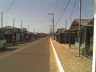
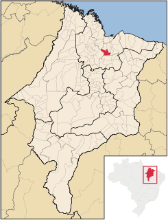
Nina Rodrigues is a municipality in the state of Maranhão in the Northeast region of Brazil.

Presidente Vargas, Maranhão Municipality in Nordeste, Brazil

Presidente Vargas is a municipality in the state of Maranhão in the Northeast region of Brazil.

Barreirinhas Municipality in Nordeste, Brazil

Barreirinhas is a municipality in the state of Maranhão in the Northeast region of Brazil.

Primeira Cruz Municipality in Nordeste, Brazil

Primeira Cruz is a municipality in the state of Maranhão in the Northeast region of Brazil.

Santo Amaro do Maranhão is a municipality in the state of Maranhão in the Northeast region of Brazil.

Bacabeira Municipality in Nordeste, Brazil

Bacabeira is a municipality in the state of Maranhão in the Northeast region of Brazil.

Cachoeira Grande is a municipality in the state of Maranhão in the Northeast region of Brazil.

Icatu is a municipality in the state of Maranhão in the Northeast region of Brazil.

Presidente Juscelino is a municipality in the state of Maranhão in the Northeast region of Brazil.

Rosário is a municipality in the state of Maranhão in the Northeast region of Brazil.

Santa Rita, Maranhão Municipality in Nordeste, Brazil

Santa Rita, Maranhão is a municipality in the state of Maranhão in the Northeast region of Brazil.

References

  1. IBGE 2020
  2. "Divisão Territorial do Brasil" (in Portuguese). Divisão Territorial do Brasil e Limites Territoriais, Instituto Brasileiro de Geografia e Estatística (IBGE). July 1, 2008. Retrieved December 17, 2009.
  3. "Estimativas da população para 1º de julho de 2009" (PDF) (in Portuguese). Estimativas de População, Instituto Brasileiro de Geografia e Estatística (IBGE). August 14, 2009. Retrieved December 17, 2009.
  4. "Ranking decrescente do IDH-M dos municípios do Brasil" (in Portuguese). Atlas do Desenvolvimento Humano, Programa das Nações Unidas para o Desenvolvimento (PNUD). 2000. Archived from the original on October 3, 2009. Retrieved December 17, 2009.
  5. "Produto Interno Bruto dos Municípios 2002-2005" (PDF) (in Portuguese). Instituto Brasileiro de Geografia e Estatística (IBGE). December 19, 2007. Archived from the original (PDF) on October 2, 2008. Retrieved December 17, 2009.
  6. APA Upaon-Açu/Miritiba/Alto Preguiças (in Portuguese), ISA: Instituto Socioambiental, retrieved 2017-02-09

Coordinates: 2°36′S43°28′W / 2.600°S 43.467°W / -2.600; -43.467