Related Research Articles

Charlevoix Municipal Airport is a city-owned, public-use airport located one nautical mile (2 km) southwest of the central business district of Charlevoix, a city in Charlevoix County, Michigan, United States. It is mostly used for general aviation, but also offers passenger service to Beaver Island via Island Airways and Fresh Air Aviation.
Fitch H. Beach Airport is a city-owned, public-use airport located two nautical miles (3.7 km) northeast of the central business district of Charlotte, a city in Eaton County, Michigan, United States. It is included in the Federal Aviation Administration (FAA) National Plan of Integrated Airport Systems for 2017–2021, in which it is categorized as a local general aviation facility.
Abrams Municipal Airport is a city-owned, public-use airport located two nautical miles (3.7 km) north of the central business district of Grand Ledge, a city in Eaton County, Michigan, United States. It is included in the Federal Aviation Administration (FAA) National Plan of Integrated Airport Systems for 2017–2021, in which it is categorized as a local general aviation facility.

Brooks Field is a city-owned, public-use airport located one nautical mile (1.85 km) south of the central business district of Marshall, a city in Calhoun County, Michigan, United States. Brooks Field was officially dedicated in 1931, although the first plane landed there on November 9, 1929.
Beaver Island Airport is a public use airport located on Beaver Island in Charlevoix County, Michigan, United States. It is owned by St. James Township and Peaine Township. It is included in the Federal Aviation Administration (FAA) National Plan of Integrated Airport Systems for 2017–2021, in which it is categorized as a local general aviation facility.
Tuscola Area Airport is a public use airport located three nautical miles (6 km) southwest of the central business district of Caro, a city in Tuscola County, Michigan, United States. It is owned by the Tuscola Area Airport Authority. It is included in the Federal Aviation Administration (FAA) National Plan of Integrated Airport Systems for 2017–2021, in which it is categorized as a local general aviation facility. Many U.S. airports use the same three-letter location identifier for the FAA and IATA. However, this airport is assigned CFS by the FAA but has been assigned TZC from the IATA. Note that CFS was assigned to Coffs Harbour Airport in Coffs Harbour, New South Wales, Australia.
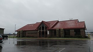
Cheboygan County Airport is a public use airport located two nautical miles (3.7 km) west of the central business district of Cheboygan, a city in Cheboygan County, Michigan, United States. It is owned by the Cheboygan Airport Authority. It is included in the Federal Aviation Administration (FAA) National Plan of Integrated Airport Systems for 2017–2021, in which it is categorized as a basic general aviation facility. The airport is accessible from Levering Road and is close to US Highway 23.
Gaylord Regional Airport is a county-owned, public-use airport located one nautical mile (2 km) southwest of the central business district of Gaylord, a city in Otsego County, Michigan, United States. It is included in the Federal Aviation Administration (FAA) National Plan of Integrated Airport Systems for 2017–2021, in which it is categorized as a local general aviation facility.

Toledo Suburban Airport is a public use airport located two nautical miles southwest of the central business district of Lambertville, a city in Monroe County, Michigan, United States. It is located just north of Michigan's border with Ohio and northwest of the city of Toledo, Ohio. It is included in the Federal Aviation Administration (FAA) National Plan of Integrated Airport Systems for 2017–2021, in which it is categorized as a general aviation facility.
Oscoda County Dennis Kauffman Memorial Airport is a county-owned, public-use airport in Oscoda County, Michigan, United States. It is located two nautical miles (4 km) north of the central business district of Mio, Michigan. Formerly known as Oscoda County Airport, it was renamed in 2011 to honor Dennis Kauffman, who served on the Oscoda County Board of Commissioners for more than 20 years.

Buzzwick Airport is a privately owned, public use airport located three nautical miles (6 km) south of the central business district of Carleton, a village in Monroe County, Michigan, United States. It is owned and operated by Buzzwick Airport LLC.
Avoca Airport is privately owned, public use airport located two nautical miles (4 km) southeast of the central business district of Avoca, in St. Clair County, Michigan, United States. It is owned by the people whose land it encompasses. Until 2008 it was known as Rasor Airport, owned and managed by William Rasor.

Milwrick Flying "M" Airport is a privately owned, public use airport located three nautical miles (6 km) northeast of the central business district of Lincoln, a village in Alcona County, Michigan, United States. It was formerly known as Flying "M" Ranch Airport.
Mayes Airport was an privately owned, public use airport located four nautical miles north-northwest of the central business district of Carson City, in Montcalm County, Michigan, United States. Although an exact date is not known, it is believed the airport closed sometime in 2008.
Double JJ Resort Ranch Airport was a privately owned, public use airport located two nautical miles northwest of the central business district of Rothbury, in Oceana County, Michigan, United States.
Yuba Airport is a privately owned, public use airport in Grand Traverse County, Michigan, United States. It is located four nautical miles south of the central business district of Elk Rapids, Michigan.
Duford Field is a privately owned, public use airport located one nautical mile (2 km) northwest of the central business district of Genesee, in Genesee County, Michigan, United States.
Lakeview Airport, also known as Griffith Field, is a public use airport in Montcalm County, Michigan, United States. It is owned by the village of Lakeview and located one nautical mile (2 km) northeast of its central business district. It is included in the Federal Aviation Administration (FAA) National Plan of Integrated Airport Systems for 2017–2021, in which it is categorized as a local general aviation facility.
Ontonagon County Airport, also known as Schuster Field, is a county-owned public-use airport located 3 miles (5 km) west of the central business district of Ontonagon, Michigan, a village in Ontonagon County, Michigan, United States. It is included in the Federal Aviation Administration (FAA) National Plan of Integrated Airport Systems for 2021–2025, in which it is categorized as a basic general aviation facility.

Schoolcraft County Airport is a county-owned public-use airport located 3 miles (5 km) northeast of the central business district of Manistique, Michigan, a city in Schoolcraft County, Michigan, United States. It is included in the Federal Aviation Administration (FAA) National Plan of Integrated Airport Systems for 2017–2021, in which it is categorized as a basic general aviation facility.
References
- 1 2 3 FAA Airport Form 5010 for 07D PDF . Federal Aviation Administration. effective July 31, 2008.
- ↑ "Avoca, Tackaberry (07D)" (PDF). Airport Directory. State of Michigan.