
The humpback whale is a species of baleen whale. It is a rorqual and is the only species in the genus Megaptera. Adults range in length from 14–17 m (46–56 ft) and weigh up to 40 metric tons. The humpback has a distinctive body shape, with long pectoral fins and tubercles on its head. It is known for breaching and other distinctive surface behaviors, making it popular with whale watchers. Males produce a complex song typically lasting 4 to 33 minutes.

Whale watching is the practice of observing whales and dolphins (cetaceans) in their natural habitat. Whale watching is mostly a recreational activity, but it can also serve scientific and/or educational purposes. A study prepared for International Fund for Animal Welfare in 2009 estimated that 13 million people went whale watching globally in 2008. Whale watching generates $2.1 billion per annum in tourism revenue worldwide, employing around 13,000 workers. The size and rapid growth of the industry has led to complex and continuing debates with the whaling industry about the best use of whales as a natural resource.

Palm Beach is a suburb in the Northern Beaches region of Sydney, in the state of New South Wales, Australia. Palm Beach is located 41 kilometres (25 mi) north of the Sydney central business district, in the local government area of Northern Beaches Council. Palm Beach sits on a peninsula at the end of Barrenjoey Road near Pittwater and is the northernmost beach in the Greater Sydney Metropolitan area. The population of Palm Beach was 1,593 as at the 2016 census.

Byron Bay is a beachside town located in the far-northeastern corner of the state of New South Wales, Australia on Bundjalung Country. It is located 772 kilometres (480 mi) north of Sydney and 165 kilometres (103 mi) south of Brisbane. Cape Byron, a headland adjacent to the town, is the easternmost point of mainland Australia. At the 2021 census, the town had a permanent population of 6,330. It is the largest town of Byron Shire local government area, though not the shire's administrative centre.

Hervey Bay is a city on the coast of the Fraser Coast Region of Queensland, Australia. The city is situated approximately 290 kilometres (180 mi) or 3½ hours' highway drive north of the state capital, Brisbane. It is located on the bay of the same name open to the Coral Sea between the Queensland mainland and nearby K'gari. The local economy relies on tourism which is based primarily around whale watching in Platypus Bay to the north, ferry access to K'gari, accessible recreational fishing and boating and the natural north facing, calm beaches with wide undeveloped foreshore zones. In October 2019, Hervey Bay was named the First Whale Heritage Site in the world by the World Cetacean Alliance, for its commitment to and practices of sustainable whale and dolphin watching. A 2010 study by Deakin University showed that people on the Fraser Coast area including Hervey Bay, were the happiest in Australia. At June 2018, there were an estimated 54,674 people in Hervey Bay, having grown by an annual average of 1.31% year-on-year over the preceding five years.

Port Macquarie, locally nicknamed Port, is a coastal city the local government area of Port Macquarie-Hastings. It is located on the Mid North Coast of New South Wales, Australia, about 390 km (242 mi) north of Sydney, and 570 km (354 mi) south of Brisbane. The city is located on the Tasman Sea coast, at the mouth of the Hastings River, and at the eastern end of the Oxley Highway (B56). The city with its suburbs had a population of 47,973 in June 2018 and an estimated population of 50,307 in June 2023.

Puysegur Point is a headland located in the far southwest of the South Island of New Zealand. It lies within Fiordland National Park on the southern head of Preservation Inlet and is 145 kilometres (90 mi) west-northwest of Invercargill.

Broulee is a town on the south coast of New South Wales between Batemans Bay and Moruya. At the 2016 census, the town had a population of 1,717. Just off the beach is Broulee Island, currently joined to the mainland, but in past years the connecting spit has been covered by water, at times a very deep navigable channel with a strong current.

Crescent Head is a town on the Mid North Coast, 340 km north-northeast of Sydney, in The Kempsey Shire local government area of New South Wales, Australia. At the 2021 census, Crescent Head had a population of 978 people. Its major industries include tourism and fishing. It has a 6-hole golf course overlooking the sea.

Castlepoint is a small beachside settlement on the Wairarapa coast of the Wellington Region of New Zealand. It is home to a lighthouse which stands near the top of the northern end of a reef. The reef is about one kilometre long. At the southern end of the reef, there is an island known locally as "seagull island", due to its large population of seagulls. The southern side of Castle Rock is known as Christmas Bay. Castlepoint is approximately one hour's drive from Masterton.
Humphrey the Whale is a humpback whale that twice deviated from his Mexico to Alaska migration by entering San Francisco Bay. This behavior is unusual for a humpback whale, and Humphrey attracted wide media attention when entering the bay in both 1985 and 1990. Both of his bay incursions resulted in rescue by the Marine Mammal Center, based in Marin County, California, assisted by the United States Coast Guard and hundreds of other volunteers.

Guafo Island is an island located southwest of Chiloé Island and northwest of Chonos Archipelago, Chile. This location and the prevailing westerly winds bring frequent rainstorms to the island. Ocean currents bring an abundance of fish into this area, making it one of the most productive marine areas in the Southern Pacific Ocean. Because of this, numerous marine vertebrates such as fur seals, sea lions and penguins come to the island to feed and reproduce.

Tacking Point Lighthouse is Australia's thirteenth oldest lighthouse. It was built on a rocky headland about 8 kilometres south of Port Macquarie in 1879 by Shepherd and Joseph William Mortley, to a design by the New South Wales Colonial Architect, James Barnet. It is operated by the Australian Maritime Safety Authority and is classified by the National Trust of Australia (NSW).
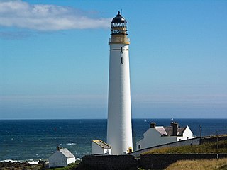
Scurdie Ness is a headland located on the South side of the River South Esk estuary, Montrose, Angus, Scotland. The River leads from the North Sea into Montrose Harbour and then into Montrose Basin. The headland has also been referred to as Scurdy Ness, Montrose point or Montroseness. The word Scurdie is a local word for the volcanic rock found there and Ness means a promontory, cape or headland. The coastline from Scurdie Ness to Rickle Craig has been designated a Site of Special Scientific Interest.

Richmond River Light, also known as Ballina Head Light and Ballina Light, is an active lighthouse located at Ballina Head, a headland in Ballina, New South Wales, Australia. The headland is at the northern side of the entrance to the Richmond River. It used to serve to guide ships into the river port and is used also serves as a leading light into the river, together with a steamer's masthead lantern with a 200 mm lens which is raised on a wooden structure 30 metres (98 ft) from it.

Crowdy Head Light is an active lighthouse located at Crowdy Head, a headland between Forster and Port Macquarie, New South Wales, Australia. It is registered with the Register of the National Estate.

Fingal Head Light is an active lighthouse located at Fingal Head, New South Wales, Australia, a headland about 5 kilometres (3.1 mi) south of Point Danger, which marks the Queensland border.

Point Lowly is the tip of a small peninsula north north-east of Whyalla in the Upper Spencer Gulf region of South Australia. The wider peninsula is shared by a combination of defence, industrial, residential, recreational and tourism interests. Port Bonython lies immediately to the north-west and is marked for future industrial expansion, driven by anticipated growth in the State's mining industry. The icons of the peninsula are the historic Point Lowly Lighthouse and the mass breeding aggregation of Australian giant cuttlefish which occurs inshore each winter.

Browse Island is a small, approximately 14-hectare (35-acre), uninhabited island lying in the Timor Sea about 180 km (110 mi) north-west of the Kimberley coast of north-western Australia. It is a Western Australian Nature Reserve that is classed as 'Not Class A' vested with the state Conservation Commission and managed by the Department of Environment and Conservation. It is considered Western Australia's most remote island, and is also one of the most remote Australian islands to not fall under external territory status.
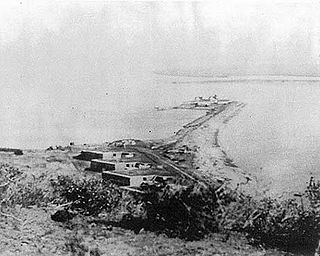
Ballast Point Whaling Station in San Diego, California in San Diego County, is a California Historical Landmark No. 50 listed on December 6, 1935. The Ballast Point Whaling Station was built in 1858 by Captain Miles A. Johnson his cousins, Henry and James A. Johnson and the twin Packard brothers, Alpheus and William, brothers. The Portuguese-American Johnsons, Alpheus and William came to San Diego from Massachusetts in 1856. The Ballast Point Whaling Station was on Ballast Point. The Whaling station processed whales to make whale oil. Whale oil was a very popular as in oil lamps it produced little smoke. Whale oil was also used in miner's headlamps, lighthouses, soaps, and candles, and as machinery lubricant. In 1869 the United States acquired the site for a quarantine station and built a lighthouse and later Fort Rosecrans, named after Major General William Rosecrans. Whaling operations at Ballast Point stopped in 1873. In 1946 the site became a United States Submarine Base. The site today is Naval Base Point Loma founded in 1959. A Ballast Point Whaling Station historic marker is located on the Navy Base. Before Ballast Point Whaling Station the site was the Spanish Fort Guijarros


