French Polynesia is an overseas collectivity of France and its sole overseas country. It comprises 121 geographically dispersed islands and atolls stretching over more than 2,000 kilometres (1,200 mi) in the South Pacific Ocean. The total land area of French Polynesia is 3,521 square kilometres (1,359 sq mi), with a population of 278,786 of which at least 205,000 live in the Society Islands and the remaining population lives in the rest of the archipelago.

Tahiti is the largest island of the Windward group of the Society Islands in French Polynesia. It is located in the central part of the Pacific Ocean and the nearest major landmass is Australia. Divided into two parts, Tahiti Nui and Tahiti Iti, the island was formed from volcanic activity; it is high and mountainous with surrounding coral reefs. Its population was 189,517 in 2017, making it by far the most populous island in French Polynesia and accounting for 68.7% of its total population; the 2022 Census recorded a population of 191,779.

Tubuai, Tubuaʻi or Tupuaʻi is the main island of the Austral Island group, located 640 km (400 mi) south of Tahiti. In addition to Tubuai, the group of islands include Rimatara, Rurutu, Raivavae, Rapa and the uninhabited Îles Maria. They are part of the Austral Islands in the far southwest of French Polynesia in the south Pacific Ocean. Tubuai island sustains a population of 2,185 people on 45 km2 of land. Due to its southerly position, Tubuai has notably cooler weather than Tahiti.
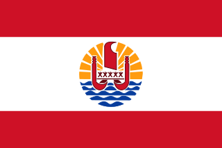
The flag of French Polynesia is the civil and state flag of the French overseas country French Polynesia. It was adopted in 1984. According to the articles of adoption, the flag of French Polynesia must be displayed with the French tricolor, and may be displayed with the flags of the component archipelagos. The French Polynesian flag must be displayed to the left of the French flag, and the flag of the archipelago must be displayed to its right.

Papeete is the capital city of French Polynesia, an overseas collectivity of the French Republic in the Pacific Ocean. The commune of Papeete is located on the island of Tahiti, in the administrative subdivision of the Windward Islands, of which Papeete is the administrative capital. Both the President of French Polynesia and French High Commissioner reside in Papeete.

Bora Bora is an island group in the Leeward Islands in the South Pacific. The Leeward Islands comprise the western part of the Society Islands of French Polynesia, which is an overseas collectivity of the French Republic in the Pacific Ocean. Bora Bora has a total land area of 30.55 km2 (12 sq mi). The main island, located about 230 kilometres northwest of Papeete, is surrounded by a lagoon and a barrier reef. In the center of the island are the remnants of an extinct volcano, rising to two peaks, Mount Pahia and Mount Otemanu; the highest point is at 727 m (2,385 ft). Bora Bora is part of the Commune of Bora-Bora, which also includes the atoll of Tūpai. The main languages spoken in Bora Bora are Tahitian and French. However, due to the high tourist population, many natives of Bora Bora have learned to speak English.

Moʻorea, also spelled Moorea, is a volcanic island in French Polynesia. It is one of the Windward Islands, a group that is part of the Society Islands, 17 kilometres (11 mi) northwest of Tahiti. The name comes from the Tahitian word Moʻoreʻa, meaning "yellow lizard": Moʻo = lizard; Reʻa = yellow. An older name for the island is ʻAimeho, sometimes spelled ʻAimeo or ʻEimeo. Early Western colonists and voyagers also referred to Moʻorea as York Island or Santo Domingo.

Huahine is an island located among the Society Islands, in French Polynesia, an overseas territory of France in the South Pacific Ocean. It is part of the Leeward Islands group (Îles sous le Vent). At the 2022 census it had a population of 6,263.

Raʻiātea or Raiatea is the second largest of the Society Islands, after Tahiti, in French Polynesia, in the South Pacific Ocean. The island is widely regarded as the "centre" of the eastern islands in ancient Polynesia and it is likely that the organised migrations to the Hawaiian Islands, and other parts of East Polynesia started at Raʻiātea.

The Austral Islands are the southernmost group of islands in French Polynesia, an overseas country of the French Republic in the South Pacific. Geographically, they consist of two separate archipelagos, namely in the northwest the Tupua'i islands consisting of the Îles Maria, Rimatara, Rūrutu, Tupua'i Island proper and Ra'ivāvae, and in the southeast the Bass Islands composed of the main island of Rapa Iti and the small Marotiri. Inhabitants of the islands are known for their pandanus fiber weaving skills. The islands of Maria and Marotiri are not suitable for sustained habitation. Several of the islands have uninhabited islets or rocks off their coastlines. Austral Islands' population is 6,965 on almost 150 km2 (58 sq mi). The capital of the Austral Islands administrative subdivision is Tupua'i.
The Gambier Islands are an archipelago in French Polynesia, located at the southeast terminus of the Tuamotu archipelago. They cover an area of 27.8 km2 or 10.7 sq mi, and are made up of the Mangareva Islands, a group of high islands remnants of a caldera along with islets on the surrounding fringing reef, and the uninhabited Temoe atoll, which is located 45 km south-east of the Mangareva Islands. The Gambiers are generally considered a separate island group from Tuamotu both because their culture and language (Mangarevan) are much more closely related to those of the Marquesas Islands, and because, while the Tuamotus comprise several chains of coral atolls, the Mangareva Islands are of volcanic origin with central high islands.
Hao, or Haorangi, is a large coral atoll in the central part of the Tuamotu Archipelago. It has c. 1000 people living on 35 km2 (14 sq mi). It was used to house the military support base for the nuclear tests on Mururoa. Because of its shape, French explorer Louis Antoine de Bougainville named it "Île de la Harpe".

The Leeward Islands are the western part of the Society Islands in French Polynesia, an overseas collectivity of France, in the South Pacific Ocean. They lie south of the Line Islands, east of the Cooks and north of the Austral Islands. Their area is around 404 km2 (156 sq mi) and their population is over 36,000.

Faʻaʻā is a commune in the suburbs of Papeʻete in French Polynesia, an overseas country of France in the Pacific Ocean. Faʻaʻā is located on the island of Tahiti, in the administrative subdivision of the Windward Islands, themselves part of the Society Islands. At the 2022 census Faʻaʻā had a population of 29,826, making it the most populous commune on Tahiti and in French Polynesia. Faʻaʻā has many mountains inland that can reach 1,500 m (5,000 ft). Mount Marau is an extinct volcano in the inland limits and can be seen from nearby Moʻorea. The area of Faʻaʻā is 9 m (30 ft) above mean sea level on average.

Uturoa is a commune located in Ra'iātea, the largest island of the Îles Sous le Vent in French Polynesia, in the South Pacific Ocean. It is situated in between the administrative subdivision of Leeward Islands and the main port of the island of Ra'iātea. According to the 2022 census, Uturoa has a population of 3,663. The commune lies approximately 120 miles (193.121 km) northwest of Pape'ete, the capital of French Polynesia.

Rimatara is the westernmost inhabited island in the Austral Islands of French Polynesia. It is located 550 km (340 mi) south of Tahiti and 150 km (93 mi) west of Rurutu. The land area of Rimatara is 8.6 km2 (3.3 sq mi), and that of the Maria islets is 1.3 km2 (0.50 sq mi). Its highest point is 106 m (348 ft). Its population was 893 at the 2022 census.
The Society Islands are an archipelago in the South Pacific Ocean that includes the major islands of Tahiti, Moʻorea, Raiatea, Bora Bora and Huahine. Politically, they are part of French Polynesia, an overseas country of the French Republic. Geographically, they form part of Polynesia.
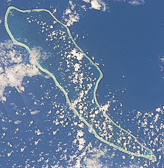
Fakarava, Havaiki-te-araro, Havai'i or Farea is an atoll in the west of the Tuamotu group in French Polynesia. It is the second largest of the Tuamotu atolls. The nearest land is Toau, a coral atoll which lies 14 kilometres to the northwest.

This page list topics related to French Polynesia.

The annexation of the Leeward Islands or the Leewards War was a series of diplomatic and armed conflicts between the French Third Republic and the native kingdoms of Raiatea-Tahaa, Huahine and Bora Bora, which resulted in the conquest of the Leeward Islands, in the South Pacific archipelago of the Society Islands in modern-day French Polynesia.


