The River Clyde is a river that flows into the Firth of Clyde, in the west of Scotland. It is the ninth-longest river in the United Kingdom, and the third longest in Scotland after the River Tay and the River Spey. It runs through the city of Glasgow. The River Clyde estuary has an upper tidal limit located at the tidal weir next to Glasgow Green.
Firth is a word in the English and Scots languages used to denote various coastal waters in the United Kingdom, predominantly within Scotland. In the Northern Isles, it more often refers to a smaller inlet. It is linguistically cognate to Scandinavian fjord and fjard, with the original meaning of "sailable waterway". The word has a more constrained sense in English. Bodies of water named "firths" tend to be more common on the Scottish east coast, or in the southwest of the country, although the Firth of Clyde is an exception to this. The Highland coast contains numerous estuaries, straits, and inlets of a similar kind, but not called "firth" ; instead, these are often called sea lochs. Before about 1850, the spelling "Frith" was more common.

Argyll and Bute is one of 32 unitary council areas in Scotland and a lieutenancy area. The current lord-lieutenant for Argyll and Bute is Jane Margaret MacLeod. The administrative centre for the council area is in Lochgilphead at Kilmory Castle, a 19th-century Gothic Revival building and estate. The current council leader is Councillor Jim Lynch.

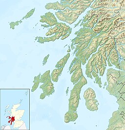
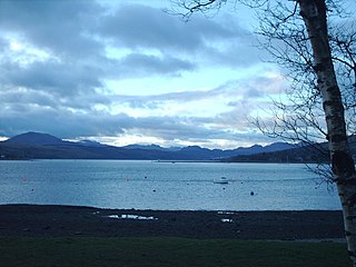
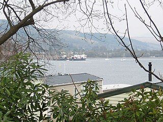
The Firth of Clyde is the estuary of the River Clyde, on the west coast of Scotland. The Firth has some of the deepest coastal waters of the British Isles. The Firth is sheltered from the Atlantic Ocean by the Kintyre Peninsula. The Firth lies between West Dunbartonshire in the north, Argyll and Bute in the west and Inverclyde, North Ayrshire and South Ayrshire in the east. The Kilbrannan Sound is a large arm of the Firth, separating the Kintyre Peninsula from the Isle of Arran. The Kyles of Bute separates the Isle of Bute from the Cowal Peninsula. The Sound of Bute separates the islands of Bute and Arran.

Dunoon is the main town on the Cowal Peninsula in the south of Argyll and Bute, west of Scotland. It is located on the western shore of the upper Firth of Clyde, to the south of the Holy Loch and to the north of Innellan. As well as forming part of the council area of Argyll and Bute, Dunoon also has its own community council. Dunoon was a burgh until 1976.

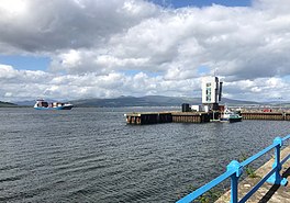
Greenock is a town in Inverclyde, Scotland, located in the west central Lowlands of Scotland. The town is currently the administrative centre of Inverclyde Council. It is a former burgh within the historic county of Renfrewshire, and forms part of a contiguous urban area with Gourock to the west and Port Glasgow to the east.

Kilcreggan is a village on the Rosneath Peninsula in Argyll and Bute, West of Scotland.
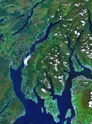
Cowal is a rugged peninsula in Argyll and Bute, on the west coast of Scotland. It is connected to the mainland to the north, and is bounded by Loch Fyne to the west, by Loch Long and the Firth of Clyde to the east, and by the Kyles of Bute to the south.

The Holy Loch is a sea loch, a part of the Cowal Peninsula coast of the Firth of Clyde, in Argyll and Bute, Scotland.

Loch Long is a body of water in the council area of Argyll and Bute, Scotland. The Sea Loch extends from the Firth of Clyde at its southwestern end. It measures approximately 20 miles in length, with a width of between one and two miles. The loch also has an arm, Loch Goil, on its western side.
The Gare Loch or Gareloch is an open sea loch in Argyll and Bute, Scotland and bears a similar name to the village of Gairloch in the north west Highlands.

Sandbank is a village on the Cowal Peninsula in Argyll and Bute, west of Scotland. It is located 2.5 miles north of Dunoon on the coastal A815 or the inland A885 and sits on the southern shore of the Holy Loch, branching off the Firth of Clyde.
Rosneath is a village in Argyll and Bute, Scotland. It sits on the western shore of the Gare Loch, 2 miles northwest of the tip of the Rosneath Peninsula. It is about 2.4 miles by road from the village of Kilcreggan, which is sited on the southern shore of the peninsula, on the Firth of Clyde.

Lyle Hill stands at the West End of Greenock in Inverclyde, Scotland. It has scenic viewpoints accessible from Lyle Road, which was constructed in 1879–1880 and named after Provost Abram Lyle, well known as a sugar refiner. The hill's highest point is Craigs Top at 426 feet above sea level, and before the road was constructed the hill was known as the Craigs, or as the Bingens.

The Captayannis was a Greek sugar-carrying vessel that sank in the Firth of Clyde, Scotland in 1974. Known as the Sugar Boat locally.
The A815 is a major road located on the Cowal peninsula, in Argyll and Bute, Scotland. It runs for about 35.7 miles (57.5 km) from the A83, near Cairndow, in the north to Toward in the south. It passes beside three lochs, while its final stretch is along the Firth of Clyde.
Ardhallow Battery is a Palmerston Fort on the slopes of Corlarach Hill around 2 miles (3.2 km) south of Dunoon, on the Cowal Peninsula, west of Scotland. Part of the local Clyde Defenses and the Scottish Coastal Defences. The construction contract was awarded to "The Aitkenhead Builders" in 1901 for a price of £16,000. The Battery is a scheduled monument. The site was used in both World Wars and decommissioned in 1956.

MV Juno was a passenger and vehicle ferry operated by Caledonian MacBrayne on the Firth of Clyde, Scotland between 1974 and 2007. She was the middle of three vessels nicknamed "streakers", the first in the Calmac fleet to be fitted with Voith Schneider Propellers. Juno left service in early 2007 and was laid up at Rosneath for 4 years. On 18 May 2011, she was beached there for scrapping and was gone by the end of July.

Rosneath Peninsula is a peninsula in Argyll and Bute, western Scotland, formerly in the historic county of Dunbartonshire. The peninsula is formed by the Gare Loch in the east, and Loch Long in the west, both merge with the upper Firth of Clyde.