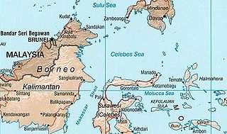
The Celebes Sea, or Sulawesi Sea, of the western Pacific Ocean is bordered on the north by the Sulu Archipelago and Sulu Sea and Mindanao Island of the Philippines, on the east by the Sangihe Islands chain, on the south by Sulawesi's Minahasa Peninsula, and on the west by northern Kalimantan in Indonesia. It extends 420 miles (675 km) north-south by 520 mi (840 km) east-west and has a total surface area of 110,000 square miles (280,000 km2), to a maximum depth of 20,300 feet (6,200 m). South of the Cape Mangkalihat, the sea opens southwest through the Makassar Strait into the Java Sea.

The Ratak Chain is a chain of islands within the island nation of the Marshall Islands. Ratak means "sunrise". It lies to the east of the country's other island chain, the Ralik Chain. In 1999 the total population of the Ratak islands was 30,925.

Bunaken is an island of 8 km2, part of the Bunaken National Marine Park. Bunaken is located at the northern tip of the island of Sulawesi, Indonesia. It belongs administratively to the municipality of Manado. Scuba diving attracts many visitors to the island.
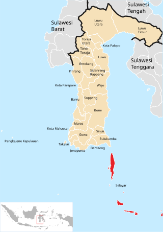
Selayar or Saleyer, is an archipelago of South Sulawesi province, Indonesia. It lies in the Flores Sea, between Sulawesi and Flores, around 150 km southeast of the major city of Makassar. Kabupaten Selayar is the Regency, covering 1,357 km² with a population of about 138,000 (2021). There are 73 islands, the main one being Selayar Island. To the east lies Pulau (Island) Kalaotoa and Pulau Karompa Lompo, and to the west lies Kepulauan Sabalana. It is a biodiverse diving site.
Selayar or Selayarese is a Malayo-Polynesian language spoken by about 100,000 people on the island of Selayar in South Sulawesi province, Indonesia.

The Selayar Islands Regency is a regency of Indonesia in South Sulawesi province that covers the Selayar Islands, which lie to the south of Sulawesi. The regency covers an area of 1,357.03 km2, and had a population of 103,596 at the 2000 Census, 122,055 at the Census of 2010 and 137,071 at that of 2020. The official estimate for mid 2021 was 137,974. The Selayar Straits separate the regency from Sulawesi island.
Selayar is the main island of the Selayar Islands. It lies off the coast of Cape Bira of South Sulawesi Province. The Selayar Straits separate it from the mainland of Sulawesi. Its main city is Benteng, towns to the south are Tanabau, Padang, Tile-tile, Pariangan, Galung, Layolo, Pa'garangang, Barangbarang, to Appattanah. To the north are Parak, Barugayya, Batangmata, Onto, and finally Bonelohe. The island is over 50 miles (80 km) long and very narrow at the eastern end; its area is 248 sq mi (640 km2). Benteng is the starting point for diving tours.

Toke Atoll or Taka Atoll is a small, uninhabited coral atoll in the Ratak Chain of the Marshall Islands. It is one of the smaller atolls in the Marshalls and located at 11°17′N169°37′E. It is visited regularly by the residents of nearby Utirik Atoll.
Selayar Strait separates Selayar Island from Cape Bira of the main island South Sulawesi Province, Indonesia. Within the strait lies Kambing Island and Pulau Pasitanete. Ferry is operating between islands in Selayar Strait.
The Wotu–Wolio languages are a group of closely related languages spoken in Sulawesi that belong to the Celebic subgroup of the Austronesian family.

The Maldives, officially the Republic of Maldives, is a small archipelagic state in South Asia. It lies in the Indian Ocean southwest of Sri Lanka and India, about 700 kilometres (430 mi) from the Asian continent's mainland. The chain of 26 atolls stretches across the Equator from Ihavandhippolhu Atoll in the north to Addu Atoll in the south. The land area is roughly 298 square kilometres. Malé is the capital.

Taka Bonerate National Park is a marine park which includes the Takabonerate atoll islands, located in the Flores Sea, south of Sulawesi island of Indonesia.

Tojo Una-Una Regency is a regency of Central Sulawesi, Indonesia. The administrative centre is at Ampana town, on the Sulawesi 'mainland'. While the Regency includes a considerable area on the eastern peninsula of Sulawesi, it also includes the Togian Islands in the Gulf of Tomini. The total area covers 5,721.51 km2 and the population was 134,945 at the 2010 Census and 163,829 at the 2020 Census; the official estimate as at mid 2021 was 166,339.

Benteng is an administrative district in the Selayar Islands Regency, South Sulawesi, Indonesia. It is the administrative capital of the Selayar Islands Regency and is located on the seafront where the means of transport from outside the closest is Benteng Pier. The nearest airport and is the only airport H. Aroeppala Airport located in Padang few miles south of Benteng Bontosunggu precisely in the village, Bontoharu District, Selayar Islands Regency. Capital city is the administrative district Benteng Citadel.

Tanah Jampea, also variously known as Tanah Djampea, Tanahjampea, Jampea Island and Pulau Jampea, is the second largest island of the Selayar Islands group in Indonesia’s South Sulawesi Province. The group lies in the Flores Sea between the much larger islands of Sulawesi to the north and Flores to the south. The island is some 22 km long by up to 10 km wide, with the highest point 521 m above sea level. It has been identified by BirdLife International as an Important Bird Area because it supports populations of critically endangered yellow-crested cockatoos and endangered Tanahjampea monarchs.

Haji Aroeppala Airport, sometimes abbreviated H. Aroeppala Airport, is an airport in Selayar Regency, South Sulawesi, Sulawesi Island, Indonesia.
The Makassaric languages are a group of languages spoken in the southern part of South Sulawesi province, Indonesia, and make up one of the branches of the South Sulawesi subgroup in the Austronesian language family. The most prominent member of this group is Makassarese, with over two million speakers in the city of Makassar and neighboring areas.
The following index is provided as an overview of and topical guide to Wikipedia's articles on recreational dive sites. The level of coverage may vary:
Persatuan Sepakbola Selayar Kepulauan is an Indonesian football club based in Selayar Islands Regency, South Sulawesi. They currently compete in the Liga 3.


