Talpa is a settlement in Taos County, New Mexico, located 6 miles (10 kilometers) south of the town of Taos along New Mexico Highway 518. [1]
Talpa is a settlement in Taos County, New Mexico, located 6 miles (10 kilometers) south of the town of Taos along New Mexico Highway 518. [1]
First named Rio Chiquito for the river running through the area, Talpa was settled during the early-18th century during the time that nearby Ranchos de Taos began to be settled. [2] The settlement is on the old Spanish land grant of Don Cristobal de la Sena. [3]
The name of the town may have been derived from the town of Talpa in Jalisco, Mexico or it may have been named for Señora Talpa Romero, of a prominent Taos family.
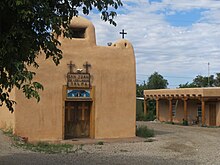
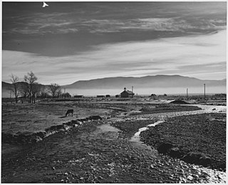
Circa 1820, a private chapel was built for the Duran family in Talpa along the Rio Chiquito. Juan Pedro Cruz (born about 1855) was a well-known weaver who supplied sarapes, embroidered bedspreads, and rugs to residents of the Taos Pueblo and local villages. Ponce de Leon Hot Springs, used by Native Americans and early Spanish settlers, are located near Talpa. [3]
It is within Taos Municipal Schools, [4] which operates Taos High School.


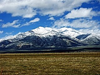
Taos is a town in Taos County in the north-central region of New Mexico in the Sangre de Cristo Mountains. Initially founded in 1615, it was intermittently occupied until its formal establishment in 1795 by Nuevo México Governor Fernando Chacón to act as fortified plaza and trading outpost for the neighboring Native American Taos Pueblo and Hispano communities, including Ranchos de Taos, Cañon, Taos Canyon, Ranchitos, El Prado, and Arroyo Seco. The town was incorporated in 1934. As of the 2010 census, its population was 5,716.
Taos County is a county in the U.S. state of New Mexico. As of the 2020 census, the population was 34,489. Its county seat is Taos. The county was formed in 1852 as one of the original nine counties in New Mexico Territory.

Mora County is a county in the U.S. state of New Mexico. As of the 2020 census, the population was 4,189. Its county seat is the census-designated place (CDP) Mora. The county has another CDP, Watrous, a village, Wagon Mound, and 12 smaller unincorporated settlements. Mora became a formal county in the US, in what was then the New Mexico Territory, on February 1, 1860. Ecclesiastically, the county is within the Roman Catholic Archdiocese of Santa Fe. County population peaked at approximately 14,000 circa 1920, declining to about 4,000 to 5,000 since the 1970s; the 2018 estimate was 4,506.

Santa Cruz, historically known as Santa Cruz de la Cañada, is a census-designated place (CDP) in Santa Fe County, New Mexico, United States. It is part of the Santa Fe, New Mexico Metropolitan Statistical Area. The population was 423 at the 2000 census.

Ranchos de Taos is a census-designated place (CDP) in Taos County, New Mexico. The population was 2,390 at the time of the 2000 census.

Jicarilla Apache, one of several loosely organized autonomous bands of the Eastern Apache, refers to the members of the Jicarilla Apache Nation currently living in New Mexico and speaking a Southern Athabaskan language. The term jicarilla comes from Mexican Spanish meaning "little basket", referring to the small sealed baskets they used as drinking vessels. To neighboring Apache bands, such as the Mescalero and Lipan, they were known as Kinya-Inde.
Mora or Santa Gertrudis de lo de Mora is a census-designated place in, and the county seat of, Mora County, New Mexico. It is located about halfway between Las Vegas and Taos on Highway 518, at an altitude of 7,180 feet. The Republic of Texas performed a semi-official raid on Mora in 1843. Two short battles of the Mexican–American War were fought in Mora in 1847, where U.S. troops eventually defeated the Hispano and Puebloan militia, effectively ending the Taos Revolt in the Mora Valley. The latter battle destroyed most of the community, necessitating its re-establishment.
Truchas is a census-designated place in Rio Arriba County, New Mexico, United States. Located along the scenic High Road to Taos, it is halfway between Santa Fe in the south, and Taos to the north.

Las Trampas or just Trampas, is an unincorporated hamlet in Taos County, New Mexico. Founded in 1751 to settle the Las Trampas Land Grant, its center retains the original early Spanish colonial defensive layout as well as the 18th-century San José de Gracia Church, one of the finest surviving examples of Spanish colonial church architecture in the United States. The village center was designated a National Historic Landmark District in 1967. The population in 2023 was 43.

Pilar is an unincorporated community in Taos County, New Mexico, United States. It is located on the Rio Grande.

Ranchos de Taos Plaza is a historic district in Ranchos de Taos, New Mexico, about four miles south of the town of Taos, New Mexico. There are 21 buildings over 84 acres in the historic district, including the San Francisco de Assisi Mission Church, a U.S. National Historic Landmark.

Taos Municipal Schools (TMS) or Taos Municipal School District (TMSD) is a school district based in Taos, New Mexico, United States. Taos Municipal Schools has a total area of 637 square miles (1,650 km2). The school district has a total of six schools. The district has one high school, one middle school, three elementary schools, and one magnet school.
El Prado is an unincorporated suburb and census designated place on the north side of Taos, in Taos County, New Mexico, United States. It is generally bounded on the south by the town of Taos, to the east by Taos Pueblo lands, to the north by Arroyo Seco and Arroyo Hondo, and to the west by the Rio Grande Gorge. The elevation is 7,123 feet. U.S. Route 64 and New Mexico State Roads 150 and 522 run through El Prado.
The 56-mile (90 km) High Road to Taos is a scenic, winding road through the Sangre de Cristo Mountains between Santa Fe and Taos.. It winds through high desert, mountains, forests, small farms, and tiny Spanish land grant villages and Pueblo Indian villages. Scattered along the way are the galleries and studios of traditional artisans and artists drawn by the natural beauty. It has been recognized by the state of New Mexico as an official scenic byway.
Velarde is a census-designated place (CDP) in Rio Arriba County, New Mexico, United States. The population was 502 at the time of the 2010 census. Velarde is located on New Mexico State Road 68, in the Rio Grande Rift, at the point where the road enters the Rio Grande Gorge.

Pot Creek Cultural Site is an abandoned 13th century pueblo located on private land owned by Southern Methodist University and on public Carson National Forest land in Taos County, New Mexico.
Tres Piedras is an unincorporated community in Taos County, northern New Mexico, United States, adjacent to Carson National Forest.
Palo Flechado Pass, also called Taos Pass and Old Taos Pass, is a mountain pass located in Taos County, New Mexico, United States on the Enchanted Circle Scenic Byway.
Taos Valley, also called Lower Taos Canyon, is a valley located in Taos County, New Mexico. It is bounded by the Rio Grande Gorge; the deep ravine, or Arroyo Hondo, of the Rio Hondo; and the Taos Mountain range. Included in the valley are Ranchos de Taos, the Taos Pueblo, and Taos Plaza.
36°20′29.71″N105°35′49.28″W / 36.3415861°N 105.5970222°W
Municipalities and communities of Taos County, New Mexico, United States | ||
|---|---|---|
| Towns |  | |
| Villages | ||
| CDPs | ||
| Other communities | ||
| Ghost towns | ||
| Indian reservation | ||
| Footnotes | ‡This populated place also has portions in an adjacent county or counties | |
| International | |
|---|---|
| National | |