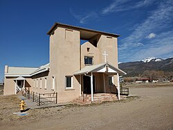
The Village of Cerro | |
---|---|
Nuestra Senora de Guadalupe Catholic Church in Cerro, March 2021 | |
Coordinates: 36°54′14″N105°36′46″W / 36.90389°N 105.61278°W | |
Country | United States |
State | New Mexico |
County | Taos |
Elevation | 7,461 ft (2,274 m) |
Population (2000) | |
• Total | 428 |
Time zone | UTC-7 (Mountain (MST)) |
• Summer (DST) | UTC-6 (MDT) |
ZIP code | 87519 |
Area code(s) | 575 |
Website | http://www.laplaza.org/government/cerro/ |
Cerro is an unincorporated community in Taos County, New Mexico, United States [1] located along New Mexico State Road 378. It was founded in 1854 by settlers from Taos and Questa and was named for Cerro Guadalupe. [2]
Coordinates: 36°45′14″N105°36′46″W / 36.75389°N 105.61278°W
Taos is a town in Taos County in the north-central region of New Mexico in the Sangre de Cristo Mountains. It was founded by Nuevo México Governor Fernando Chacón in 1795, to act as fortified plaza and trading outpost for the neighboring Native American Taos Pueblo and Hispano communities, including Ranchos de Taos, Cañon, Taos Canyon, Ranchitos, El Prado, and Arroyo Seco. The town was incorporated in 1934. As of the 2010 census, its population was 5,716.
Taos County is a county in the U.S. state of New Mexico. As of the 2010 census, the population was 32,937. Its county seat is Taos. The county was formed in 1852 as one of the original nine counties in New Mexico Territory.
Questa is a village in Taos County, New Mexico, United States. The population was 1,770 at the 2010 census. The village has trails into the Rio Grande Gorge, trout fishing, and mountain lakes with trails that access the Sangre de Cristo Mountains that overlook the area. Questa is on the Enchanted Circle Scenic Byway, near the confluence of the Rio Grande and the Red River. The "Gateway to the Rio Grande del Norte Monument", its visitors can drive to an overlook of the Red River meeting the Rio Grande in the depth of the gorge. The Carson National Forest parallels Questa to the east. The Columbine Hondo Wilderness and Latir Peak Wildness are in the Carson National Forest close to Questa.
Taos Pueblo is a census-designated place (CDP) in Taos County, New Mexico, just north of Taos. The population was 1,264 at the 2000 census.
Arroyo Hondo is a census-designated place in Taos County near Taos, New Mexico, United States. It is historically notable as the site of the killing of six to eight employees by a force of allied Native Americans at Simon Turley's mill and distillery trading post on January 20, 1847. This took place during the Taos Revolt, a populist insurrection of New Mexicans and Native Americans against the new United States territorial regime during the Mexican–American War.
Truchas is an unincorporated community and census-designated place in Rio Arriba County, New Mexico. Located along the scenic High Road to Taos, it is halfway between Santa Fe in the south, and Taos to the north.
Hillside is an unincorporated community and a U.S. Post Office in Fremont County, Colorado, United States. The Hillside Post Office has the ZIP Code 81232.
Pilar is an unincorporated community in Taos County, New Mexico, United States. It is located on the Rio Grande.
Cantonment Burgwin was a U.S. Army fort in the southwestern United States, located ten miles (16 km) south of Taos, New Mexico, southeast of Ranchos De Taos. Established 169 years ago in 1852 to protect the Taos Valley from Utes and Jicarilla Apaches, it was named for Captain John H. K. Burgwin in honor of his death in 1847 while fighting at the Siege of Pueblo de Taos, and he was buried there. It was designated a "cantonment" to indicate its temporary character.
Embudo is an unincorporated community in Rio Arriba County, New Mexico, United States. It is on NM State Road 68. The Embudo Station is located 2.9 miles south of the intersection of NM State Road 75, near where the Embudo River flows into the Rio Grande.
El Prado is an unincorporated suburb of Taos, in Taos County, New Mexico, United States. El Prado is located at latitude 36.449 and longitude 105.576. It is bounded on the east by the town of Taos, and to the north by Taos Pueblo lands. The elevation is 7,123 feet.
Carson is an unincorporated community in southwestern Taos County, New Mexico, United States. Named after frontiersman and Taos resident Kit Carson, Carson was founded c. 1908, when the surrounding area was opened for homesteading. Carson is a low-density rural residential area.
El Rito in an unincorporated community in Taos County, New Mexico, United States.
Amalia is an unincorporated community in Taos County, New Mexico, United States. Amalia is located at latitude 36.942 and longitude -105.454. Amalia is located near the Colorado border, on New Mexico State Road 196. The elevation is 8,143 feet.
Costilla is a census-designated place in Taos County, New Mexico, United States. Its population was 205 as of the 2010 census. Costilla has a post office with ZIP code 87524. State roads 196 and 522 intersect in the community.
San Cristobal is a census-designated place in Taos County, New Mexico, United States. Its population was 273 as of the 2010 census. San Cristobal has a post office with ZIP code 87564, which opened on February 16, 1932.
Talpa is a settlement in Taos County, New Mexico, located 6 miles south of the town of Taos along New Mexico Highway 518.
Tres Piedras is an unincorporated community in northern New Mexico, United States, adjacent to Carson National Forest.
Palo Flechado Pass, also called Taos Pass and Old Taos Pass, is a mountain pass located in Taos County, New Mexico on the Enchanted Circle Scenic Byway.
The San Luis Hills are a group of small mountain ranges in Conejos and Costilla counties in the San Luis Valley in southern Colorado. The individual mountain ranges that make up the San Luis Hills include the Fairy Hills, the Brownie Hills, the Piñon Hills, and the South Piñon Hills. The San Luis Hills' highest point is Flat Top, elevation 9,206 feet