Kaski District (Nepali: कास्की जिल्ला[kaski], a part of Gandaki Province, is one of the seventy-seven districts of Nepal. The name is disambiguated from Kaskikot, the ancient Kaski Kingdom.
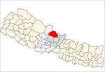
Manang District (Nepali: मनाङ जिल्लाListen , a part of Gandaki Province, is one of the seventy-seven districts of Nepal. The district, with Chame as its district headquarters, covers an area of 2,246 km2 and had a population of 6,538.
Chame is the headquarters of Manang District in the Gandaki Zone of northern Nepal. At the time of the 2011 Nepal census it had a population of 1129 people living in 279 individual households. Manang District is the lowest populated district in Nepal.

Manang is a town in the Manang District of Nepal. It is located at 28°40'0N 84°1'0E with an altitude of 3,519 metres (11,545 ft). According to the preliminary result of the 2011 Nepal census it has a population of 6,527 people living in 1,495 individual households. Its population density is 3 persons/km2.

A Village Development Committee (VDC) in Nepal was the lower administrative part of its Ministry of Federal Affairs and Local Development. Each district had several VDCs, similar to municipalities but with greater public-government interaction and administration. There were 3,157 village development committees in Nepal. Each VDC was further divided into several wards depending on the population of the district, the average being nine wards.
The 1991 Nepal census was a widespread national census conducted by the Nepal Central Bureau of Statistics.

Bagarchhap is a village development committee in Manang District in the Gandaki Zone of northern Nepal. At the time of the 1991 Nepal census it had a population of 534 people living in 116 individual households.

Bhraka, Nepal is a village development committee in Manang District in the Gandaki Zone of northern Nepal. At the time of the 2011 Nepal census it had a population of 306 people living in 83 individual households.

Dharapani is a village development committee in Manang District in the Gandaki Zone of northern Nepal. At the time of the 2001 Nepal census it had a population of 1012 people living in 232 individual households.

Phu, Nepal is a village development committee in Manang District in the Gandaki Zone of northern Nepal. At the time of the 2011 Nepal census it had a population of 176 people living in 36 individual households.

Ghyaru is a village development committee in Manang District in the Gandaki Zone of northern Nepal. At the time of the 2011 Nepal census it had a population of 71 people living in 33 individual households.
Khangsar is a village development committee in Manang District in the Gandaki Zone of northern Nepal. At the time of the 2011 Nepal census it had a population of 257 people in 58 individual households.

Nar is a village development committee in Manang District in the Gandaki Zone of northern Nepal. In the 2011 Nepal census it had a population of 362 people, living in 86 individual households.

Ngawal (Nawal) is a village development committee in Manang District in the Gandaki Zone of northern Nepal. At the time of the 2011 Nepal census it had a population of 274. Ngawal VDC is one of the Seven Village Development Committee in Upper Manang. One of the main attraction of this village is a centuries-old cave of Guru Rinpoche that is on the hills overlooking Ngawal village. The local people believes the cave leads to Mustang. And a monastery in Tibetan Nyingma pa sect which is called Portoche Monastery. 16

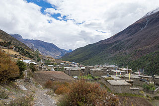
Pisang is a village development committee in Manang District in the Gandaki Zone of northern Nepal. At the time of the 2011 Nepal census it had a population of 307 people living in 105 individual households. The village is located in the Marshyangdi River valley, directly south of Pisang Peak, north of Annapurna II, and west of Paungda Danda.
Tachi Bagarchhap is a village development committee in Manang District in the Gandaki Zone of northern Nepal. At the time of the 2011 Nepal census it had a population of 544.
Thoche is a village development committee in Manang District in the Gandaki Zone of northern Nepal. At the time of the 2011 Nepal census it had a population of 382 people living in 102 individual households.

Pathari Shanishchare (पथरी-शनिश्चरे) is a Municipality in Morang District in the Koshi Zone of south-eastern Nepal. It was formed by merging three existing village development committees i.e. Hasandaha, Pathari and Sanischare in May 2014.
Nepal conducted a widespread national census in 2011 by the Nepal Central Bureau of Statistics. Working with the 58 municipalities and the 3915 Village Development Committees at a district level, they recorded data from all the municipalities and villages of each district. The data included statistics on population size, households, sex and age distribution, place of birth, residence characteristics, literacy, marital status, religion, language spoken, caste/ethnic group, economically active population, education, number of children, employment status, and occupation.

Gandaki Province is one of the seven federal provinces established by the current constitution of Nepal which was promulgated on 20 September 2015. Pokhara is the province's capital city. It borders the Tibet Autonomous Region of China to the north, Bagmati Province to the east, Karnali Province to the west, and Lumbini Province and Bihar of India to the south. The total area of the province is 21,504 km² - about 14.57% of the country's total area. According to the latest census, the population of the province was 2,403,757. The newly elected Provincial Assembly adopted Gandaki Province as the permanent name by replacing its initial name Province no. 4 in July 2018. Krishna Chandra Nepali is the present chief minister of Gandaki province