Related Research Articles

Edgecombe County is a county located in the U.S. state of North Carolina. As of the 2020 census, the population was 48,900. Its county seat is Tarboro.

Tarboro is a town located in Edgecombe County, North Carolina, United States. It is part of the Rocky Mount Metropolitan Statistical Area. As of the 2020 census, the town had a population of 10,721. It is the county seat of Edgecombe County. The town is on the opposite bank of the Tar River from Princeville. It is also part of the Rocky Mount-Wilson-Roanoke Rapids CSA. Tarboro is located near the western edge of North Carolina's coastal plain. It has many historical churches, some dating from as early as 1742.
Grand Rapids Gerald R. Ford International Airport is a commercial airport in Cascade Township, approximately 13 miles (21 km) southeast of Grand Rapids, Michigan, United States. The facility is owned by the Kent County Board of Commissioners and managed by an independent authority. The US Federal Aviation Administration (FAA) National Plan of Integrated Airport Systems for 2017–2021 categorized it as a small hub primary commercial service facility.
Naples Airport, formerly known as Naples Municipal Airport, is a public use airport located two nautical miles (4 km) northeast of the central business district of Naples, the most populous city and county seat of Collier County, Florida. It is owned by the Naples Airport Authority. The airport is home to flight schools, air charter operators, car rental agencies, and corporate aviation and non-aviation businesses. The airport is also a central location for public services, including fire/rescue services, mosquito control, the Collier County Sheriff's Aviation Unit and other community services.
McGhee Tyson Airport is a public/military airport 12 miles (19 km) south of Knoxville, in Alcoa, Tennessee. It is named for United States Navy pilot Charles McGhee Tyson, who was killed in World War I.

The Northrop T-38 Talon is a two-seat, twinjet supersonic jet trainer designed and produced by the American aircraft manufacturer Northrop Corporation. It was the world's first supersonic trainer as well as the most produced.

Rocky Mountain Metropolitan Airport is a public-use airport located in Broomfield, Colorado, United States. The airport is owned and operated by Jefferson County and is situated midway between Denver and Boulder on U.S. Highway 36. It is located 16 miles (26 km) northwest of the central business district of Denver, and is the closest airport to downtown Denver. The airport covers 1,700 acres (688 ha) and has three runways. Formerly known as Jefferson County Airport or Jeffco Airport, the airport was renamed Rocky Mountain Metropolitan Airport on October 10, 2006, although it is sometimes referred to as Rocky Mountain Regional Airport, e.g., on 2007–2012 county planning documents.

Mobile International Airport is a public use airport located three nautical miles (6 km) south of the central business district of Mobile, a city in Mobile County, Alabama, United States. The airport is a principal component of the Mobile Aeroplex at Brookley, a 1,650-acre (668 ha) industrial complex. Presently the facility covers 1,616 acres of land. It is owned and operated by the Mobile Airport Authority. Prior to 1969, the airport was part of an active military installation known as Brookley Air Force Base.
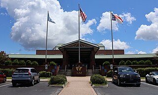
Wilmington International Airport is a public airport located just north of Wilmington, North Carolina, in unincorporated Wrightsboro. ILM covers 1,800 acres.
North Palm Beach County Airport, also known as North County Airport, is an uncontrolled (non-towered) general aviation airport located 12 nautical miles northwest of West Palm Beach off the Bee Line Highway in Palm Beach Gardens, Florida. The airport is owned by Palm Beach County and operated by the Palm Beach County Airports Department. Opened in 1994, it is the county's newest airport. It is located next to the site of the "fake" town of Apix, Florida.

Abraham Lincoln Capital Airport is a civil-military airport in Sangamon County, Illinois, United States, three miles (6 km) northwest of downtown Springfield. It is owned by the Springfield Airport Authority (SAA).

Addison Airport is a public airport in Addison, in Dallas County, Texas, United States, 9 mi north of downtown Dallas. It opened in 1954 and was purchased by the town of Addison in 1976.
Smyrna Airport is a public general aviation and military use airport located two nautical miles (4 km) north of the central business district of Smyrna, a town in Rutherford County, Tennessee, United States. It is owned by the Smyrna / Rutherford County Airport Authority. Smyrna Airport is the third largest airport in Tennessee and is the state's busiest general aviation airport. Prior to March 1971, the facility was an active military installation known as Sewart Air Force Base.
Marion County Airport is a county-owned public airport located in the unincorporated area of Dunnellon, in Marion County, Florida, United States. In 2014, the general aviation airport averaged 105 flights per day. The complex features two lighted runways with no control tower. During World War II, the airport was used by the United States Army Air Forces for training and was then known as the Dunnellon Army Air Field.
Greater Kankakee Airport is a public use airport located three nautical miles (6 km) south of the central business district of Kankakee, a city in Kankakee County, Illinois, United States. It is included in the National Plan of Integrated Airport Systems for 2011–2015, which categorized it as a general aviation facility.
Northeastern Regional Airport is a public use airport in Chowan County, North Carolina, United States. It is owned by the town of Edenton and located three nautical miles southeast of its central business district. This airport is included in the National Plan of Integrated Airport Systems for 2011–2015, which categorized it as a general aviation facility.

Doylestown Airport is a public airport in Bucks County, Pennsylvania, owned by the Bucks County Airport Authority (BCAA). It is two nautical miles north of Doylestown, Pennsylvania and has a single fixed-base operator, Leading Edge Aviation, Civil Air Patrol squadron 907, flight training, and aircraft rentals.
Chester County G. O. Carlson Airport is a public airport 2 miles (3.2 km) west of Coatesville, in Valley Township, Chester County, Pennsylvania. It is owned by the Chester County Area Airport Authority.
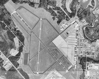
Rocky Mount–Wilson Regional Airport is a public airport located seven miles (11 km) southwest of the central business district of Rocky Mount, a city located in Nash and Edgecombe Counties in the U.S. state of North Carolina. It is also north of Wilson, a city in Wilson County. The airport is owned by the Rocky Mount–Wilson Airport Authority.

La Junta Municipal Airport is three miles north of La Junta, in Otero County, Colorado, United States. The National Plan of Integrated Airport Systems for 2011–2015 categorized it as a general aviation facility.
References
- 1 2 "KETC – Tarboro-Edgecombe Airport". AirNav. Retrieved September 2, 2024.
- ↑ "Airport Facilities". Town of Tarboro. Retrieved September 2, 2024.
- ↑ "Airport Authority". Town of Tarboro. Retrieved September 2, 2024.