Tashigang, Himachal Pradesh

Last updated

Tashigang
Village and Monastery
India Himachal Pradesh location map.svg
Red pog.svg
Tashigang
Location in Himachal Pradesh, India
Coordinates: 31°50′24″N78°41′48″E / 31.84010°N 78.69669°E / 31.84010; 78.69669
CountryFlag of India.svg  India
State Himachal Pradesh
District Kinnaur
Languages
  Official Hindi
  Local Spiti
Time zone UTC+5:30 (IST)
Vehicle registration HP-27

Tashigang is a village near an ancient monastery in the state of Himachal Pradesh, India. It is the highest polling station in the world, at a staggering altitude of 15,256 feet above msl. It is a settlement in Kinnaur and is located in the Sutlej river valley near the India-Tibet border. National Highway 5 connects Khab with state capital Shimla. Below Tashigangis flows the Sutlej river, which originates from Mansarovar Lake in Tibet. The villages of Nako and Khab are nearby. Current Tashigang is controlled by India but claimed by Zanda County, Ngari Prefecture, Tibet, China. You can go to the mountain Gang Chua via here through a pass.

Contents

Claims

According to some maps, the territory is disputed between India and China, [1] [2] while in others it is not. [3]

Transportation

Tashigang can be reached by foot from Nako and Khab.

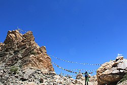
Pass on the way to Tashigang from Nako. The pass on the way to Tashigang from Nako.jpg
Pass on the way to Tashigang from Nako.

See also

Related Research Articles

<span class="mw-page-title-main">Line of Actual Control</span> Disputed boundary between China and India

The Line of Actual Control (LAC), in the context of the Sino-Indian border dispute, is a notional demarcation line that separates Indian-controlled territory from Chinese-controlled territory. The concept was introduced by Chinese premier Zhou Enlai in a 1959 letter to Jawaharlal Nehru as the "line up to which each side exercises actual control", but rejected by Nehru as being incoherent. Subsequently, the term came to refer to the line formed after the 1962 Sino-Indian War.

<span class="mw-page-title-main">Kinnaur district</span> District of Himachal Pradesh in India

Kinnaur district is one of the twelve administrative districts of the state of Himachal Pradesh in northern India. The district is divided into three administrative areas and has six tehsils. The administrative headquarters of the district is at Reckong Peo. The revered Kinnaur Kailash mountain, one of the Panch Kailash sites, is situated in Kinnaur. As of 2011, it is the second least populous district of Himachal Pradesh, after Lahaul and Spiti.

<span class="mw-page-title-main">Sutlej</span> River in Asia

The Sutlej River is the longest of the five rivers that flow through the historic crossroads region of Punjab in northern India and Pakistan. The Sutlej River is also known as Satadru. It is the easternmost tributary of the Indus River. The Bhakra Dam is built around the river Sutlej to provide irrigation and other facilities to the states of Punjab, Rajasthan and Haryana.

<span class="mw-page-title-main">Rudok</span> Village in Rutog County, Ngari, Tibet

Rudok, also spelt Rutok and Rutog, more properly Rudok Dzong, is a town that served as the historical capital of the Rudok area in Western Tibet on the frontier with Ladakh. In the 1911 Encyclopædia Britannica, it is described as being "picturesquely situated" on the side of a hill standing isolated in the plain near the east end of Lake Pangong.

<span class="mw-page-title-main">Shipki La</span> Mountain pass in India and China

Shipki La is a mountain pass and border post with a dozen buildings of significant size on the India-China border. The river Sutlej, which is called Langqên Zangbo in Tibet, enters India near this pass. A spur road on the Indian side rises to an altitude of 4,720 metres (15,490 ft) four km southwest of Shipki La.

<span class="mw-page-title-main">Spiti</span> River valley in Himachal Pradesh, India

Spiti is a high-altitude region of the Himalayas, located in the north-eastern part of the northern Indian state of Himachal Pradesh. The name "Spiti" means "The middle land", i.e. the land between Tibet and India. Spiti incorporates mainly the valley of the Spiti River, and the valleys of several rivers that feed into the Spiti River. Some of the prominent side-valleys in Spiti are the Pin valley and the Lingti valley. Spiti is bordered on the east by Tibet, on the north by Ladakh, on the west and southwest by Lahaul, on the south by Kullu, and on the southeast by Kinnaur. Spiti has a cold desert environment. The valley and its surrounding regions are among the least populated regions of India. The Bhoti-speaking local population follows Tibetan Buddhism.

<span class="mw-page-title-main">Sino-Indian border dispute</span> Border dispute between China and India

The Sino–Indian border dispute is an ongoing territorial dispute over the sovereignty of two relatively large, and several smaller, separated pieces of territory between China and India. The first of the territories, Aksai Chin, is administered by China and claimed by India; it is mostly uninhabited high-altitude wasteland but with some significant pasture lands at the margins. It lies at the intersection of Kashmir, Tibet and Xinjiang, and is crossed by China's Xinjiang-Tibet Highway; the other disputed territory is south of the McMahon Line, in the area formerly known as the North-East Frontier Agency and now a state called Arunachal Pradesh. It is administered by India and claimed by China. The McMahon Line was signed between British India and Tibet to form part of the 1914 Simla Convention, but the latter was never ratified by China. China disowns the McMahon Line agreement, stating that Tibet was not independent when it signed the Simla Convention.

Demchok (Tibetan: བདེ་མཆོག, Wylie: bde mchog, THL: dem chok, ZYPY: dêmqog), is a Chinese-administered village in the Zhaxigang Township, Ngari Prefecture in the Tibet Autonomous Region of China. India disputes the status and claims it as part of the Demchok sector that it regards as part of Ladakh.

<span class="mw-page-title-main">Nako, Himachal Pradesh</span> Village in Himachal Pradesh, India

Nako is a village in the Himalayas of northern India, located near the Indo-China border in the Trans-Himalayan region of Kinnaur district in Himachal Pradesh. Nako Lake is a prominent feature here where it borders the village. Nako Monastery, dated to 1025, is located in the village as well as several other Buddhist chortens.

<span class="mw-page-title-main">Khab</span> Village in Himachal Pradesh, India

Khab is a small village in the state of Himachal Pradesh, India. It is located in the Sutlej river valley near the India-Tibet border. National Highway 5 connects Khab with state capital Shimla. Khab sangam is the confluence of Spiti river and Sutlej river. The Spiti river flowing through the spiti valley here meets the Sutlej, which originates from Mansarovar Lake in Tibet. The ancient monastery of Tashigang Gompa is nearby. The peak of Reo Purgil, which rises to 22,400 feet (6,800 m), is visible and the cold desert of Spiti lies across the nearby bridge.

The Kalapani territory is an area under Indian administration as part of Pithoragarh district in the Kumaon Division of the Uttarakhand state, but it is also claimed by Nepal since 1997. According to Nepal's claim, it lies in Darchula district, Sudurpashchim Province. The territory represents part of the basin of the Kalapani river, one of the headwaters of the Kali River in the Himalayas at an altitude of 3600–5200 meters. The valley of Kalapani, with the Lipulekh Pass at the top, forms the Indian route to Kailash–Manasarovar, an ancient pilgrimage site. It is also the traditional trading route to Tibet for the Bhotiyas of Kumaon and the Tinkar valley of Nepal.

<span class="mw-page-title-main">Disputed territories of India</span>

There are several disputed territories of India. A territorial dispute is a disagreement over the possession or control of land between two or more states or over the possession or control of land by a new state and occupying power after it has conquered the land from a former state no longer currently recognized by the new state.

Chumar or Chumur is a village and the centre of nomadic grazing region located in south-eastern Ladakh, India. It is in Rupshu block, south of the Tso Moriri lake, on the bank of the Parang River, close to Ladakh's border with Tibet. Since 2012, China has disputed the border in this area, though the Chumur village itself is undisputed.

<span class="mw-page-title-main">National Highway 5 (India)</span> National highway in North India

National Highway 5 (NH5) is a primary national highway in India, running from West to East, connecting Firozpur in Punjab to the Sino-Indian border at Shipki La. The highway passes through Moga, Jagraon, Ludhiana, Mohali, Chandigarh, Panchkula, Kalka, Solan, Shimla, Theog, Narkanda, Kumarsain, Rampur Bushahr and continues along the Sutlej River till its terminus near the Tibet border.

<span class="mw-page-title-main">Demchok, Ladakh</span> Village in Ladakh, India

Demchok , previously called New Demchok, and called Parigas by the Chinese, is a village and military encampment in the Indian-administered Demchok sector, that is disputed between India and China. It is administered as part of the Nyoma tehsil in the Leh district of Ladakh by India, and claimed by China as part of the Tibet Autonomous Region.

<span class="mw-page-title-main">Reo Purgyil</span> Himalayan mountain

Reo Purgyil, sometimes known as Leo Pargial and Leo Pargil, is a mountain peak at the southern end of the Zanskar Range in the Western Himalaya. It is located on the border between Himachal Pradesh, India and Tibet, China.

<span class="mw-page-title-main">National Highway 505 (India)</span> National Highway in Himachal Pradesh, India

National Highway 505, commonly called NH 505, is a national highway in India. It is a spur road of National Highway 5. NH 505 traverses the state of Himachal Pradesh in India. NH 505 is a high elevation road, covering the Kinnaur and Lahaul and Spiti districts of Himachal Pradesh, mainly running along the Spiti River in the Spiti Valley. The highway from Kaza to Gramphu remains closed for 6–9 months in a year due to heavy snowfall and the closure of Kunzum La pass at an elevation of 4,550 m (14,930 ft).

The Charding Nullah, traditionally known as the Lhari stream and called Demchok River by China, is a small river that originates near the Charding La pass that is also on the border between the two countries and flows northeast to join the Indus River near a peak called "Demchok Karpo" or "Lhari Karpo". There are villages on both sides of the mouth of the river called by the same name "Demchok", which is presumed to have been a single village originally, and has gotten split into two due to geopolitcal reasons. The river serves as the de facto border between China and India in the southern part of the Demchok sector.

The Demchok sector is a disputed area named after the villages of Demchok in Ladakh and Demchok in Tibet, situated near the confluence of the Charding Nullah and Indus River. It is a part of the greater Sino-Indian border dispute between China and India. Both China and India claim the disputed region, with a Line of Actual Control between the two nations situated along the Charding Nullah.

Tsosib Sumkyil or Churup Sumkhel is the westernmost township of the Zanda County in the Ngari Prefecture, Tibet region of China. It borders India's Spiti region in Himachal Pradesh as well as Rupshu region in Ladakh. The region is watered by the Pare Chu river, a tributary of the Spiti River and an upstream tributary of the Sutlej river. China has ongoing border disputes with India for the southwestern border of the region near Kaurik and the northern border near Chumar.

References