| Gang Chua | |
|---|---|
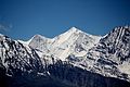
 North aspect | |
| Highest point | |
| Elevation | 6,288 m (20,630 ft) [1] [2] [3] |
| Prominence | 1,057 m (3,468 ft) [1] |
| Parent peak | Rangrik Rang [1] |
| Isolation | 26.9 km (16.7 mi) [1] |
| Coordinates | 31°38′50″N78°39′13″E / 31.647178°N 78.653516°E [1] |
| Geography | |
 Gang Chua Location of Gang Chua in India | |
 | |
| Interactive map of Gang Chua | |
| Country | India |
| State | Himachal Pradesh |
| District | Kinnaur |
| Parent range | Himalayas |
| Climbing | |
| First ascent | 1974 [3] |
Gang Chua is a mountain in India.