Tavistock MRT station

Last updated

 CR10 
Tavistock
达维士笃
தெவிஸ்தொக்
Future Mass Rapid Transit (MRT) station
Tavistock MRT station site 270622.jpg
Tavistock MRT station site
General information
Coordinates 1°22′12″N103°51′48″E / 1.37004°N 103.86328°E / 1.37004; 103.86328
Owned by Land Transport Authority
Line(s)
Platforms2 (1 island platform)
Tracks2
Construction
Structure typeUnderground
AccessibleYes
History
Opening2030;7 years' time (2030)
Services
Preceding station Mass Rapid Transit Following station
Serangoon North
towards Aviation Park
Cross Island Line
Future service
Ang Mo Kio
towards Bright Hill
Location
SGMRT-LRT map.svg
Red Dot.svg
Tavistock
Tavistock station in Singapore

Tavistock MRT station is a future underground Mass Rapid Transit station on the Cross Island line located in Serangoon planning area, Singapore.

It will be located underneath Ang Mo Kio Avenue 3, at the junction of Tavistock Avenue and Ang Mo Kio Industrial Park 2 as well as being in the vicinity of industries at Ang Mo Kio Industrial Park 2, residential developments around Tavistock, and community amenities such as Chen Su Lan Methodist Children's Home, Ling Kwang Home, Cheshire Home, Serangoon Gardens Food Centre and the French School of Singapore (Lycée Français de Singapour).

History

On 25 January 2019, the Land Transport Authority (LTA) announced that Tavistock station would be part of the proposed Cross Island line (CRL). The station will be constructed as part of Phase 1, which will consist of 12 stations from the Aviation Park to Bright Hill stations. It was expected to be completed in 2029. [1] [2] [3] However, the restrictions imposed on construction works due to the COVID-19 pandemic led to delays and the CRL1 completion date was pushed by one year to 2030. [4] A second stage from Bright Hill to Jurong Lake District stations is targeted to open in 2032.

On 13 January 2022, the LTA awarded Contract CR115 to Sato Kogyo (S) at S$407 million (US$298.3 million). [5] The contract involves the design and construction of the station and associated tunnels. [6] Construction works for the station and tunnels are scheduled to begin in the first quarter of 2022, and expected to be completed by 2030. Due to the station's location in a built-up area, the launch shaft for the tunnel boring machine will be at a distance from the station site. Tunnelling through old alluvium soil, the boring machine has to be closely monitored for wear and tear. [5] [7] [8]

Related Research Articles

<span class="mw-page-title-main">North–South MRT line</span> Mass Rapid Transit line in Singapore

The North–South Line (NSL) is a high-capacity Mass Rapid Transit (MRT) line in Singapore, operated by SMRT Corporation. Coloured red on the Singapore rail map, the line is 45 kilometres (28 mi) long and serves 27 stations, 11 of which, between the Bishan and Marina South Pier stations, are underground. It runs from Jurong East station, located in Western Singapore, to Marina South Pier station in the Central Area, via Woodlands station in northern Singapore. The line operates for almost 20 hours a day, with headways of up to 1 to 2 minutes during peak hours and 5 to 8 minutes during off-peak hours. All the trains on the North–South Line run with a six-car formation.

<span class="mw-page-title-main">Ang Mo Kio</span> Planning Area and HDB Town in Singapore

Ang Mo Kio is a planning area and residential town situated in the North-East of Singapore. Located approximately 11 km (6.8 mi) north of the Downtown Core district, Ang Mo Kio is the 3rd most populated planning area in the North-East Region and ranks 8th in terms of population in the country overall. The planning area is located at the south-western corner of the North-East Region, bordered by the planning areas of Yishun to the north, Sengkang to the north-east, Serangoon to the east, Bishan to the south and the Central Water Catchment to the west.

<span class="mw-page-title-main">Pasir Ris MRT station</span> Mass rapid transit station in Singapore

Pasir Ris MRT station is an elevated Mass Rapid Transit (MRT) station on the East West line (EWL) in Pasir Ris, Singapore. Situated along Pasir Ris Central adjacent to Pasir Ris Bus Interchange and the White Sands Shopping Mall, it is the eastern terminus of the EWL and, as of June 2021, the only MRT station within Pasir Ris. The station exterior has the characteristic dome-shaped segmented roof also seen on other elevated EWL stations.

<span class="mw-page-title-main">Ang Mo Kio MRT station</span> Mass Rapid Transit station in Singapore

Ang Mo Kio MRT station is an above-ground Mass Rapid Transit (MRT) station on the North South Line in Ang Mo Kio, Singapore.

<span class="mw-page-title-main">Hougang</span> Planning Area and HDB Town in North-East Region ----, Singapore

Hougang or Aukang is a planning area and mature residential town located in the North-East Region of Singapore. The town is the most populous in the region, being home to 247,528 residents as of 2018. Hougang planning area is bordered by Sengkang to the north, Geylang and Serangoon to the south, Bedok to the southeast, Toa Payoh to the southwest, Paya Lebar to the east, Ang Mo Kio to the west and Bishan to the southwest.

<span class="mw-page-title-main">Hougang MRT station</span> Mass Rapid Transit station in Singapore

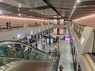
Hougang MRT station is an underground Mass Rapid Transit (MRT) station on the North East line (NEL) in Hougang, Singapore. Underneath Hougang Central and Hougang Central Bus Interchange, the station serves various landmarks, including Hougang Mall and Hougang Sports Hall.

<span class="mw-page-title-main">Yio Chu Kang MRT station</span> Mass Rapid Transit station in Singapore

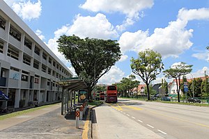
Yio Chu Kang MRT station is an above-ground Mass Rapid Transit (MRT) station on the North South line in Ang Mo Kio, Singapore, near the junction of Ang Mo Kio Avenue 6 and Ang Mo Kio Avenue 8.

<span class="mw-page-title-main">Jurong Region MRT line</span> Future Medium Capacity Mass Rapid Transit line in Singapore

The Jurong Region Line (JRL) is a future Mass Rapid Transit (MRT) line that will serve the western part of Singapore. The JRL was first announced in 2013, and is set to open in stages from 2027 to 2029. The JRL will have 24 stations, serving Choa Chu Kang in the north, Jurong Pier in the south, Peng Kang Hill in the west and Pandan Reservoir in the east. An extension to Haw Par Villa station is under consideration. The line is coloured teal/cyan on the rail map.

<span class="mw-page-title-main">North-East Region, Singapore</span> Region in Singapore

The North-East Region of Singapore is one of the five regions in the country. The region is the most densely populated and has the highest population among the five, with Sengkang being its most populous town as of 2020 and Seletar as the regional centre. Comprising 13,810 hectares, it includes seven planning areas and is largely a residential region with 217,120 homes. Housing largely consists of high-density HDB public housing estates, however private housing is also present in the region. As its name implies, it is located in the north-eastern part of Singapore.

<span class="mw-page-title-main">North–South Corridor, Singapore</span>

The North–South Corridor (NSC), originally conceptualised as the North-South Expressway, is an under-construction expressway that will be the 11th of Singapore's network of expressways when completed. The North South Corridor will serve increasing traffic along the north-south corridor that is currently served by the Central Expressway (CTE). The 21 kilometres (13 mi) expressway will cost about S$7–8 billion when fully completed in 2029 as North-South Corridor and will connect the East Coast Parkway (ECP) with the northern parts of Singapore.

<span class="mw-page-title-main">Bright Hill MRT station</span> Mass Rapid Transit station in Singapore

Bright Hill MRT station is an underground Mass Rapid Transit station on the Thomson–East Coast line (TEL). Situated along Sin Ming Avenue in western Bishan, Singapore, it serves various residential estates around the station. It also serves landmarks such as Peirce Secondary School, Ai Tong School, Bishan-Ang Mo Kio Park and the Kong Meng San Phor Kark See Monastery.

<span class="mw-page-title-main">Cross Island MRT line</span> Future Mass Rapid Transit line in Singapore

The Cross Island Line (CRL) is a high capacity Mass Rapid Transit (MRT) line under development in Singapore. It will run in an east–west direction from Changi to Jurong Industrial Estate via Loyang, Pasir Ris, Hougang, Ang Mo Kio, Sin Ming, Bukit Timah, Clementi and West Coast. From Pasir Ris, the line will branch off to Punggol. The 58-kilometre (36 mi) line will replace the East West Line as the longest line on the MRT network upon its complete opening by the 2040s, serving about 27 stations.

<span class="mw-page-title-main">Teck Ghee MRT station</span> Future Mass Rapid Transit station in Singapore

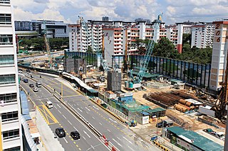
Teck Ghee MRT station is a future underground Mass Rapid Transit station on the Cross Island line located on the boundary of Ang Mo Kio and Bishan planning areas, Singapore. It will be located underneath Ang Mo Kio Avenue 6, between the junctions of Ang Mo Kio Street 31 and Ang Mo Kio Avenue 1.

<span class="mw-page-title-main">Aviation Park MRT station</span> Future Mass Rapid Transit station in Singapore

Aviation Park MRT station is a future underground Mass Rapid Transit station on the Cross Island line (CRL) located in Changi, Singapore, located next to Changi Coast Road and Aviation Park Road. The station will serve the Airport Logistics Park of Singapore, FedEx – TNT Ship Center, Changi Exhibition Centre, Changi Ferry Terminal and Changi Beach Park.

<span class="mw-page-title-main">Loyang MRT station</span> Future Mass Rapid Transit station in Singapore

Loyang MRT station is a future underground Mass Rapid Transit station on the Cross Island line (CRL) located in Pasir Ris, Singapore. It will be located underneath Loyang Avenue, at the junction with Loyang Lane.

<span class="mw-page-title-main">Pasir Ris East MRT station</span> Future Mass Rapid Transit station in Singapore

Pasir Ris East MRT station is a future underground Mass Rapid Transit station on the Cross Island MRT line located in Pasir Ris, Singapore. It will be located along Pasir Ris Drive 1, between Pasir Ris Street 12 and Pasir Ris Street 11.

<span class="mw-page-title-main">Serangoon North MRT station</span> Future Mass Rapid Transit station in Singapore

Serangoon North MRT station is a future underground Mass Rapid Transit station on the Cross Island line located on the boundary of Serangoon and Hougang planning areas, Singapore. It will be located underneath Ang Mo Kio Avenue 3, at the junctions of Serangoon North Avenue 1 and Serangoon North Avenue 3.

<span class="mw-page-title-main">Defu MRT station</span> Future Mass Rapid Transit station in Singapore

Defu MRT station is a future underground Mass Rapid Transit (MRT) station on the Cross Island MRT line (CRL) in Hougang planning area, Singapore. It will be located at Tampines Road at the junction of Defu Avenue 2 and will serve the industries near Tampines Road and Defu Industrial Park.

<span class="mw-page-title-main">Tampines North MRT station</span> Future Mass Rapid Transit station in Singapore

Tampines North MRT station is a future underground Mass Rapid Transit station on the Cross Island line located in Tampines, Singapore. Upon opening, this MRT station will be in close proximity with Tampines North Bus Interchange, IKEA Tampines, COURTS Megastore and Giant Tampines. It will also serve the residents of the future Tampines North New Town.

<span class="mw-page-title-main">Changi East Depot</span> Future MRT depot in Singapore

Changi East Depot is a future train depot in Changi East, Singapore. At 57 ha (140-acre), the at-grade depot will house 70 to 80 trains of the Cross Island line (CRL) fleet. The depot will be located along Aviation Park Road near the Changi Exhibition Centre. Other facilities of the depot include the Operations Control Centre (OCC) for the CRL. First announced in 2019, the depot is expected to be completed in 2030 along with the first stage of the CRL.
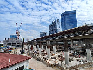
References

  1. "Joint News Release by the Land Transport Authority (LTA) & SLA – Cross Island Line 1: New Links by 2029". LTA (Press release). 25 January 2019. Archived from the original on 5 March 2020. Retrieved 5 March 2020.
  2. Tan, Christopher (25 January 2019). "First phase of Cross Island MRT line finalised; will have 12 stations". The Straits Times. Archived from the original on 5 March 2020. Retrieved 5 March 2020.
  3. Yusof, Amir (25 January 2019). "First phase of Cross Island Line to open by 2029 with 12 stations". Channel NewsAsia. Archived from the original on 5 March 2020. Retrieved 5 March 2020.
  4. "Written Reply by Minister for Transport Ong Ye Kung to Parliamentary Question on Updates on Thomson East Coast Line, Jurong Region Line and Cross Island Line". Ministry of Transport. 11 May 2021. Archived from the original on 17 May 2021. Retrieved 17 May 2021.
  5. 1 2 "Construction of Serangoon North, Tavistock MRT stations to begin in second quarter of 2022". CNA. 13 January 2022. Archived from the original on 15 January 2022. Retrieved 15 January 2022.
  6. "Contact CR115" (PDF). LTA. Archived (PDF) from the original on 29 December 2021. Retrieved 15 January 2022.
  7. "LTA Awards Two Civil Contracts for Cross Island Line Phase 1". LTA. 13 January 2022. Archived from the original on 13 January 2022. Retrieved 15 January 2022.
  8. Toh, Ting Wei (13 January 2022). "LTA awards 2 contracts worth $861m for construction of Serangoon North, Tavistock MRT stations". The Straits Times. Archived from the original on 15 January 2022. Retrieved 15 January 2022.