
The Tamar is a river in south west England that forms most of the border between Devon and Cornwall. A large part of the valley of the Tamar is protected as the Tamar Valley National Landscape, and some is included in the Cornwall and West Devon Mining Landscape due to its historic mining activities.

Tavistock is an ancient stannary and market town in West Devon, England. It is situated on the River Tavy, from which its name derives. At the 2011 census, the three electoral wards had a population of 13,028. The town traces its recorded history back to at least 961 when Tavistock Abbey, whose ruins lie in the centre of the town, was founded. Its most famous son is Sir Francis Drake.
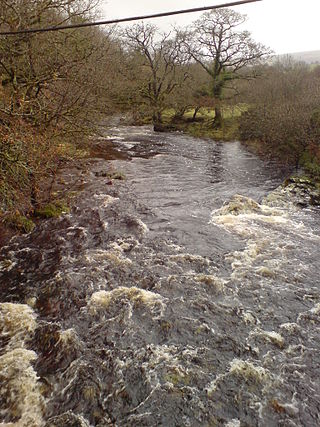
The Tavy is a river on Dartmoor, Devon, England. The name derives from the Brythonic root "Tam", once thought to mean 'dark' but now generally understood to mean 'to flow'. It has given its name to the town of Tavistock and the villages of Mary Tavy and Peter Tavy.

The Tamar Valley Line is a railway line from Plymouth, Devon, to Gunnislake, Cornwall, in England, also known as the Gunnislake branch line. The line follows the River Tamar for much of its route. Like all railway lines in Devon and Cornwall, it is unelectrified and all trains are diesel powered. The entire line is single track past St. Budeaux Junction.

Bere Alston is a village in West Devon in the county of Devon in England. It forms part of the civil parish of Bere Ferrers.
The Plymouth, Devonport and South Western Junction Railway (PD&SWJR) was an English railway company. It constructed a main line railway between Lydford and Devonport, in Devon, England, enabling the London and South Western Railway (LSWR) to reach Plymouth more conveniently than before.

St Budeaux Victoria Road railway station is a suburban station in St Budeaux, Plymouth, Devon, England. The station is managed and served by Great Western Railway.

Bere Ferrers station on the Tamar Valley Line is situated near the village of Bere Ferrers in Devon, England. The station is on the former Southern main line between Exeter and Plymouth via Okehampton. It is currently operated by Great Western Railway (GWR).
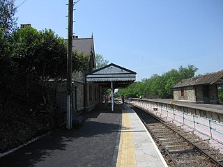
Bere Alston railway station serves the village of Bere Alston in Devon, England, 10+1⁄4 miles (16.5 km) north of Plymouth on the Tamar Valley Line to Gunnislake.

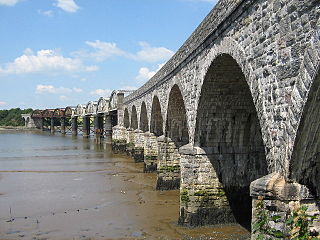
Calstock railway station is an unstaffed railway station on the Tamar Valley Line serving the village of Calstock in Cornwall, United Kingdom. It is situated at the north end of Calstock Viaduct which carries the railway at high level over the River Tamar.

The South Devon and Tavistock Railway linked Plymouth with Tavistock in Devon; it opened in 1859. It was extended by the Launceston and South Devon Railway to Launceston, in Cornwall in 1865. It was a broad gauge line but from 1876 also carried the standard gauge trains of the London and South Western Railway between Lydford and Plymouth: a third rail was provided, making a mixed gauge. In 1892 the whole line was converted to standard gauge only.
The East Cornwall Mineral Railway was a 1,067 mm gauge railway line, opened in 1872 to connect mines and quarries in the Callington and Gunnislake areas in east Cornwall, England, with shipping at Calstock on the River Tamar. The line included a rope-worked incline to descend to the quay at Calstock.

The Exeter to Plymouth railway of the London and South Western Railway (LSWR) was the westernmost part of a route competing with that of the Great Western Railway (GWR) and its 'associated companies' from London and Exeter to Plymouth in Devon, England. Whereas the GWR route from Exeter followed the coast to Newton Abbot and then went around the southern edge of Dartmoor, the LSWR route followed the northern and western margins of Dartmoor, passing through the towns of Crediton, Okehampton, and Tavistock.

Lydford railway station was a junction at Lydford between the Great Western Railway (GWR) and London and South Western Railway (LSWR) situated in a remote part of north-west Dartmoor in Devon, England.

Devonport Kings Road railway station was the London and South Western Railway station in Devonport, Devon, England. It opened in 1876 and closed in 1964. For the first 14 years it was a terminal station with trains to London departing eastwards, but from 1890 it became a through station with trains to London departing westwards.

Tamerton Foliot was a railway station, built by the Plymouth, Devonport and South Western Junction Railway (PDSWJR) on its line from Lydford to Devonport Kings Road and Plymouth Friary on the section that is now the Tamar Valley Line.

Tavistock North was a railway station serving the town of Tavistock, operated by the Plymouth, Devonport and South Western Junction Railway, but forming part of the Exeter to Plymouth section of the London and South Western Railway.
Tavistock railway station is a proposed new station to serve Tavistock in Devon, England, in order to reinstate a rail connection between the town and Plymouth, about 13 miles (21 km) to the south.

Wilminstone is a village in the civil parish of Mary Tavy in the West Devon district of Devon, England. Its nearest town is Tavistock, which lies approximately 1.1 miles (1.8 km) south-west of the hamlet. Wilminstone is situated on the C157 a few hundred yards north of the A386; this is also part of National Cycle Route No.27. The River Wallabrooke flows alongside. Just to the north was Wilminstone Quarry, which once provided more than 1,200 tonnes of roadstone per week; it is now abandoned and flooded. Wilminstone stood on the Plymouth, Devonport and South Western Junction Railway line from Bere Alston to Lydford; the line and the station closed in 1968. The large railway viaduct where the line crossed the Wallabrooke still exists today.


