| Tawang Chu | |
|---|---|
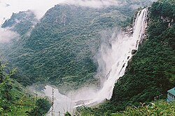 | |
 Confluence of Tawang Chu and Kholong Chu in Bhutan  Tawang Chu (Arunachal Pradesh) | |
| Location | |
| Country | India; Bhutan |
| District | Tawang district (Arunachal Pradesh); Trashiyangtse and Trashigang |
| Physical characteristics | |
| Source | Tsona Chu |
| • location | Tsona County, Tibet |
| • coordinates | 28°05′24″N92°03′32″E / 28.090°N 92.059°E |
| 2nd source | Mago Chu |
| • location | Tawang district, Arunachal Pradesh |
| • coordinates | 27°51′18″N92°16′59″E / 27.855°N 92.283°E |
| • elevation | 3,360 m (11,020 ft) |
| Mouth | Kholong Chu |
• location | Duksum, Trashiyangtse District, Bhutan |
• coordinates | 27°26′02″N91°34′26″E / 27.434°N 91.574°E |
• elevation | 1,040 m (3,410 ft) |
| Basin features | |
| Progression | Drangme Chu, Manas River |
| River system | Brahmaputra |
Tawang Chu (Tawang river) is the main river of the Tawang district in Arunachal Pradesh, India. The entire district may be regarded as the basin of the Tawang Chu river. In addition, two south-flowing rivers from Tibet, viz., the Tsona Chu and Nyamjang Chu, join the river within the district. The combined river flows west into Bhutan, where it progresses to the Manas River (tributary of Brahmaputra River) and flows into the Assam state of India.
Contents
Tawang Chu is formed by the joining of three rivers originating within the Tawang district: the Goshu Chu, Dungma Chu and Gorjo Chu. These rivers merge near the village of Mago ( 27°41′15″N92°12′26″E / 27.6876°N 92.2072°E ), after which the combined river is called Mago Chu. After Tsona Chu joins it, near Kyelatongbo at an elevation of 2,240 metres (7,350 ft), the combined river is called Tawang Chu. The river flows west towards Bhutan, passing by the Tawang town on its southern flank. [1] Near Jang, between Mago & Tawang, the Nuranang River joins Tawang Chu. Near Lumla, the Nyamjang Chu river originating in Tibet joins Tawang Chu.
Tawang Chu enters Bhutan after passing the Dudunghar Circle of the Tawang district. At Duksum, the river merges with the Kholong Chu river flowing from the north. [2] The combined river is called Drangme Chhu (or Manas River).
