| Nuranang Falls | |
|---|---|
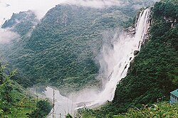 Nuranang Falls | |
 | |
| Location | Tawang, Arunachal Pradesh, India |
| Coordinates | 27°35′22″N91°59′03″E / 27.5895355°N 91.9840622°E |
| Type | curtain |
| Total height | 100 m |
| Number of drops | 2 |
| Watercourse | Nuranang Chu |

Nuranang Falls (also known as Jang Falls & Bong Bong Falls ), 100 m high waterfall, is located 2 km northeast of the Jang town on the motorable Jang Falls Road in the Tawang district of Arunachal Pradesh state of India. Jang is 40 km southeast of Tawang, north of Sela Tunnel, and between Tawang and Bomdila on NH-13 Trans-Arunachal Highway. Jang Hydal Plant, near the base of fall, is a small hydel plant which generates electricity for local use. [1] [2]
Contents
The Nuranang river originates from the Northern slopes of the Sela Pass. Shortly after the waterfall it confluences with the Tawang river. [3] Nuranang river and Nuranang falls are named after a local Monpa girl named Nura (also spelled as "Noora") who had helped an Indian Army soldier, Rifleman Jaswant Singh Rawat, Maha Vir Chakra (posthumous) in the Battle of Nooranang during the 1962 Sino-Indian War and was later captured by the Chinese PLA forces.