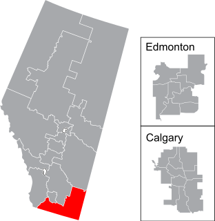
Medicine Hat—Cardston—Warner is a federal electoral district in southern Alberta, Canada, that has been represented in the House of Commons of Canada since 1908.
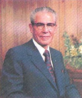
Nathan Eldon Tanner was a politician from Alberta, Canada, and a leader of The Church of Jesus Christ of Latter-day Saints. He served in the Legislative Assembly of Alberta from 1935 to 1952 as a member of the Social Credit caucus in government. He served as Speaker of the Legislative Assembly from 1936 to 1937 and as a cabinet minister in the governments of William Aberhart and Ernest Manning from 1937 to 1952, in various portfolios related to resource industries.

Cardston is a town in Alberta, Canada. It was first settled in 1887 by members of The Church of Jesus Christ of Latter-day Saints who travelled from Utah, via the Macleod-Benton Trail, to present-day Alberta in one of the century's last wagon migrations. The founder of the town was Charles Ora Card. The combined church and school was completed by January 29 the year following their arrival.
Cardston was a provincial electoral district in Alberta, Canada, mandated to return a single member to the Legislative Assembly of Alberta from 1905 to 1993.
Cardston-Chief Mountain was a provincial electoral district in Alberta, Canada, mandated to return a single member to the Legislative Assembly of Alberta using the first-past-the-post method of voting from 1993 to 1997.
Whiskey Gap, originally known as "Fareham", is a ghost town in Cardston County, Alberta, Canada. The former community is approximately 80 km (50 mi) south of the city of Lethbridge, 31.2 km (19.4 mi) southeast of the town of Cardston and 18.2 km (11.3 mi) west of Del Bonita on Highway 501.
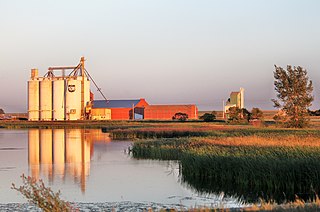
Raymond is a town in southern Alberta, Canada that is surrounded by the County of Warner No. 5. It is south of Lethbridge at the junction of Highway 52 and Highway 845. Raymond is known for its annual rodeo during the first week of July and the large population of members of The Church of Jesus Christ of Latter-Day Saints. Raymond is also significant for its connection to the history of the Japanese experience in Alberta. The town has a rich history in high school sports, basketball, Canadian football, Judo and women's rugby. Raymond was recently mentioned as one of the first communities in Alberta to become a net-zero solar-powered community, after having installed solar panels on most town buildings.

Cardston County is a municipal district in southern Alberta, Canada. It is located in Census Division 3 around the Town of Cardston.

Martin Woolf Sr. was a politician, civil servant and police magistrate from Alberta, Canada. He served as a member of the Legislative Assembly of Alberta from 1912 to 1921 sitting with the Liberal caucus in government.
Since its organization in New York in 1830, The Church of Jesus Christ of Latter-day Saints has had a presence in Canada. The church's first missionaries to preach outside of the United States preached in Upper Canada; the first stake to be established outside of the U.S. was the Alberta Stake; and the Cardston Alberta Temple was the first church temple built outside of the boundaries of the United States.
Woolford is a hamlet in southern Alberta, Canada within Cardston County. It is located on Highway 503, approximately 16 kilometres (9.9 mi) southeast of Cardston between the St. Mary River and the Milk River Ridge. It is named after Thomas Woolford who came to the area in 1900.
Mountain View is a hamlet in Alberta, Canada within Cardston County. It is located along Highway 5 approximately 25 kilometres (16 mi) west of Cardston and 20 kilometres (12 mi) east of Waterton Lakes National Park near the United States border. It is also a kickoff point for visitors to Police Outpost Provincial Park, 18 kilometers to the south.
Kimball is a hamlet in southern Alberta, Canada within Cardston County. It is located on Highway 501, approximately 16 kilometres (9.9 mi) southeast of Cardston between the St. Mary River and the Milk River Ridge. The community is named after the Mormon ward which was named after the descendants of Heber C Kimball.
Leavitt is a hamlet in southern Alberta, Canada within Cardston County, located about 13 kilometres (8 mi) west of Cardston on Highway 5. It falls within the Canadian federal electoral district of Medicine Hat—Cardston—Warner.
Aetna is a hamlet in southern Alberta, Canada within Cardston County, located 2 kilometres (1.2 mi) east of Highway 2, approximately 70 kilometres (43 mi) southwest of Lethbridge.
Beazer is a hamlet in southern Alberta, Canada within Cardston County, located 6 kilometres (3.7 mi) south of Highway 5, approximately 80 kilometres (50 mi) southwest of Lethbridge. It is named in 1900 after Mark Beazer who organized the first congregation of The Church of Jesus Christ of Latter-day Saints there.
Spring Coulee is a hamlet in southern Alberta, Canada within Cardston County, located 2 kilometres (1.2 mi) east of Highway 5, approximately 42 kilometres (26 mi) southwest of Lethbridge.

The following communities were founded by The Church of Jesus Christ of Latter-day Saints in Alberta:
Harrisville was a community in Cardston County, Alberta, Canada, to the southwest of Cardston. It had a school district and a Roman Catholic church – the first in the southern part of Alberta – which blew down in 1906. The school closed in 1948.
