Tchagen Airport

Last updated
Tchagen Airport
Summary
Airport type Public
Serves Tchagen
LocationFlag of Chad.svg  Chad
Elevation  AMSL 1,096 ft / 334 m
Coordinates 10°2′21.9″N016°18′57.4″E / 10.039417°N 16.315944°E / 10.039417; 16.315944 (Tchagen Airport (Tchagen)) Coordinates: 10°2′21.9″N016°18′57.4″E / 10.039417°N 16.315944°E / 10.039417; 16.315944 (Tchagen Airport (Tchagen))
Map
Chad adm location map.svg
Airplane silhouette.svg
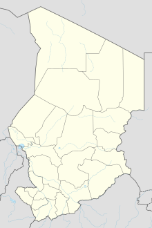
Tchagen
Location of Tchagen Airport in Chad
Runways
Direction Length Surface
ft m
16/34 2,700 823 Grass
Source: Landings.com [1] [2]

Tchagen Airport is a public use airport located near Tchagen, Tandjilé, Chad.

Airport location where aircraft take off and land

An airport is an aerodrome with extended facilities, mostly for commercial air transport. Airports often have facilities to store and maintain aircraft, and a control tower. An airport consists of a landing area, which comprises an aerially accessible open space including at least one operationally active surface such as a runway for a plane to take off or a helipad, and often includes adjacent utility buildings such as control towers, hangars and terminals. Larger airports may have airport aprons, taxiway bridges, air traffic control centres, passenger facilities such as restaurants and lounges, and emergency services. In some countries, the US in particular, they also typically have one or more fixed-base operators, serving general aviation.

Chad Country in central Africa

Chad, officially the Republic of Chad, is a landlocked country in north-central Africa. It is bordered by Libya to the north, Sudan to the east, the Central African Republic to the south, Cameroon and Nigeria to the southwest, and Niger to the west. It is the fifth largest country in Africa and the second-largest in Central Africa in terms of area.

Contents

See also

Related Research Articles

Adré Airport

Adré Airport is a public use airport located near Adré, Ouaddaï, Chad.

Am Dam Airport

Am-Dam Airport is a public use airport located near Am-Dam, Sila, Chad.

Daguessa Airport

Daguessa Airport is a public use airport located near Daguessa, Sila, Chad.

Djédaa Airport

Djédaa Airport is a public use airport located near Djédaa, Batha, Chad.

Doba Airport airport

Doba Airport is a public use airport located near Doba, Logone Oriental, Chad.

Guéréda Airport

Guéréda Airport is a public use airport located near Guéréda, Wadi Fira, Chad.

Haraze Airport

Harazé Airport is a public use airport located near Harazé, Salamat, Chad.

Koukou Angarana Airport public airport located near Koukou Angarana, Sila, Chad

Koukou Angarana Airport is a public use airport located near Koukou Angarana, Sila, Chad.

Zouar Airport

Zouar Airport is a public use airport located near Zouar, Tibesti, Chad.

Ati Airport

Ati Airport is a public use airport located near Ati, Batha, Chad.

Bokoro Airport

Bokoro Airport is a public use airport located near Bokoro, Hadjer-Lamis, Chad.

Bol-Bérim Airport airport in Chad

Bol-Berim Airport is a public use airport located near Bol, Lac, Chad.

Bousso Airport airport

Bousso Airport is a public use airport located near Bousso, Chari-Baguirmi, Chad.

Laï Airport

Laï Airport is a public use airport located near Laï, Tandjilé, Chad.

Goz Beïda Airport

Goz Beïda Airport is a public use airport located 5 kilometres (3 mi) east-southeast of Goz Beïda, Sila, Chad.

Mao Airport public use airport located near Mao, Kanem, Chad

Mao Airport is a public use airport located near Mao, Kanem, Chad.

Melfi Airport airport

Melfi Airport is a public use airport located near Melfi, Guéra, Chad.

Mongo Airport

Mongo Airport is a public use airport located near Mongo, Guéra, Chad.

Oum Hadjer Airport

Oum-Hadjer Airport is a public use airport located near Oum-Hadjer, Batha, Chad.

Bardaï-Zougra Airport

Bardai-Zougra Airport is a joint public/military airport located near Bardai, Tibesti, Chad.

References

  1. Airport record for Tchagen Airport at Landings.com. Retrieved 2013-08-28
  2. Google (2013-08-28). "location of Tchagen Airport" (Map). Google Maps . Google. Retrieved 2013-08-28.