
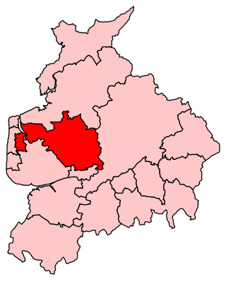
Wyre is a local government district with borough status on the coast of Lancashire, England. The council is based in Poulton-le-Fylde and the borough also contains the towns of Cleveleys, Fleetwood, Garstang, Preesall and Thornton, along with numerous villages and surrounding rural areas. Some of the borough's built-up areas form part of the wider Blackpool urban area. Eastern parts of the borough lie within the Forest of Bowland, a designated Area of Outstanding Natural Beauty.

Poulton-le-Fylde, commonly shortened to Poulton, is a market town in Lancashire, England, situated on the coastal plain called the Fylde. In the 2021 United Kingdom census, it had a population of 18,115.
Thornton is a village in the Borough of Wyre, about 4 miles (6 km) north of Blackpool and 2 miles (3 km) south of Fleetwood. The civil parish of Thornton became an urban district in 1900, and was renamed Thornton-Cleveleys in 1927. In 2011, the Thornton built-up area sub division had a population of 18,941.

Fylde is a constituency in Lancashire which since 2024 has been represented in the House of Commons of the UK Parliament by Andrew Snowden, a Conservative.
Wyre and Preston North was a county constituency represented in the House of Commons of the Parliament of the United Kingdom. Created in 2010, it elected one Member of Parliament (MP) by the first past the post voting system.

Burn Naze Halt railway station served Burn Naze in Thornton-Cleveleys, Lancashire, England, between 1909 and 1970. The platforms were heavily overgrown with vegetation until 2014, when the Poulton & Wyre Railway Society began restoration work.
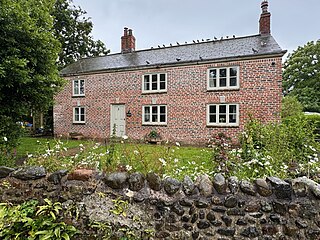
Raikes Farmhouse is a historic building in Thornton-Cleveleys, Lancashire, England. Replacing a building dating from at least 1595, the current structure was built in 1692, with a rear extension added in the 19th century. It has been designated a Grade II listed building by Historic England. The property is located on Raikes Road, just southeast of its junction with Stanah Road and Hillylaid Road.

Erected in 1921, the Poulton-le-Fylde War Memorial is located in the English market town of Poulton-le-Fylde, Lancashire. A Grade II listed structure, it stands in a small cobbled area at the north end of Market Place, having been moved from nearby Queen's Square in 1979. Made of granite, it consists of a pillar with an octagonal foot, and a ball finial surmounted by a wheel-head cross. The pillar is on a square plinth on an octagonal step. On the plinth is a timber plaque with a coat of arms, a bronze plaque with an inscription, and further plaques recording the names of those lost in the World Wars and another conflict.

The Old Town Hall is a building on Church Street in the market town of Poulton-le-Fylde in Lancashire, England. The building, which is located just beyond the northern end of Market Place, started life as a public house before becoming a municipal building and then reverting to use as a public house.
Queen's Square is a formerly open area in the centre of the English market town of Poulton-le-Fylde, Lancashire. It stands today, immediately to the southeast of Market Place, at the convergence of Blackpool Old Road to the west, Chapel Street and Higher Green to the east and Hardhorn Road to the south.
Market Place is a pedestrianised public square in the English market town of Poulton-le-Fylde, Lancashire. Dating to the Middle Ages, it has historically been a site of weekly markets, today taking place on Mondays. It is now mostly used as a shopping precinct, along with the adjacent indoor Teanlowe Centre. It is bounded by Church Street to the north and Blackpool Old Road to the south.

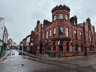
The Golden Ball is a public house and hotel on Ball Street in the English market town of Poulton-le-Fylde, Lancashire. Built in the 19th century, it was originally a coaching inn for travellers making their way to local towns and villages. During the course of its existence, the building has been a police courtroom, a newsroom and a café. Ball Street is named for the pub.

Blackpool Old Road is a street in the market town of Poulton-le-Fylde, Lancashire, England. It runs for about 1.65 miles (2.66 km), from Poulton Road and Garstang Road in the south to Queen's Square and Hardhorn Road to the northeast. It becomes the B5268 when it passes Blackpool Road, which carries the designation to and from that point. Blackpool Old Road was formerly known as Bull Street, named for the public house which stands across from Market Place. The pub was rebuilt in 1963.

Ball Street is a historic street in the market town of Poulton-le-Fylde, Lancashire, England. It runs for about 300 feet (100 yd), from the junction of Chapel Street, Vicarage Road and Breck Road in the east to its convergence with Tithebarn Street in the west. It is one-way westbound. The street, which is the start or end of today's B5267, has existed since at least the 19th century, which is when the Golden Ball public house was built. To the right of the Golden Ball once stood two houses. The shop at 5A Ball Street occupies the former entrance to one of the houses. One of them became a small private school.

The Bull is a public house on Blackpool Old Road in the English market town of Poulton-le-Fylde, Lancashire. The original pub, named The Black Bull Inn, was built in the 19th century and gave its name to the street on which it stood. Bull Street was renamed Blackpool Old Road in the 20th century. The pub, named the Bull Hotel, was rebuilt in 1963.

Victoria Road is a major thoroughfare in Thornton-Cleveleys, Lancashire, England. Originally known as Ramper Road, it runs for about 2 miles (3.2 km) from Station Road in Thornton, in the east, to South Promenade in Cleveleys, in the west. Its addresses are denoted as "Victoria Road East" or "Victoria Road East", the split occurring at the Amounderness Way roundabout carrying traffic of the A585 between Poulton-le-Fylde and Fleetwood. The road picks up the B5412 designation from Station Road until The Crescent and Brighton Avenue in Cleveleys.

Church Street is a historic street in the market town of Poulton-le-Fylde, Lancashire, England. It runs for about 210 feet, from Ball Street in the north to Market Place in the south. An entrance to the Teanlowe Centre shopping precinct is located where Church Street merges into Market Place. The street was pedestrianised in 1983.
Breck Road is a road in Poulton-le-Fylde, Lancashire, England. Originally known as Breck Street, it runs for about 0.79 miles (1.27 km) from Chapel Street, Ball Street and Vicarage Road in the south to Amounderness Way in the north.

2 Market Place is a Grade II listed building in the English market town of Poulton-le-Fylde, Lancashire. Built in the late 17th or early 18th century, it stands immediately to the south of St Chad's Church, itself Grade II* listed and dating to the 17th century, in the northeastern corner of Market Place. It was formerly a custom house, later a residence.

Tithebarn Street is a historic street in the market town of Poulton-le-Fylde, Lancashire, England. It runs for about 0.34 miles (0.55 km), from a convergence with Ball Street in the east to a convergence with Poulton Road in the west. Part of the B5267, it is one-way westbound from Ball Street to Queensway.


