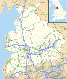
Wyre is a local government district with borough status on the coast of Lancashire, England. The council is based in Poulton-le-Fylde and the borough also contains the towns of Cleveleys, Fleetwood, Garstang, Preesall and Thornton, along with numerous villages and surrounding rural areas. Some of the borough's built-up areas form part of the wider Blackpool urban area. Eastern parts of the borough lie within the Forest of Bowland, a designated Area of Outstanding Natural Beauty.

Poulton-le-Fylde, commonly shortened to Poulton, is a market town in Lancashire, England, situated on the coastal plain called the Fylde. In the 2021 United Kingdom census, it had a population of 18,115.
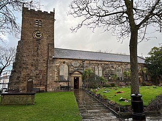
Poulton-le-Fylde is a market town in the Wyre district of Lancashire, England, situated on a coastal plain called the Fylde. There are 16 buildings and structures in the town which have been listed by the Secretary of State for Culture, Olympics, Media and Sport as being of special architectural, historical or cultural significance. One is classified as Grade II*, and the rest as Grade II; Poulton-le-Fylde has no Grade I listed buildings. The Grade II* designation is for St Chad's Church. There is written evidence of a church on the site since 1094, although it may have been built earlier. It became the Anglican parish church at the time of the Reformation and was largely rebuilt in the 18th century.

St Chad's Church is an Anglican church in Poulton-le-Fylde, Lancashire, England. It is an active parish church in the Diocese of Blackburn and the archdeaconry of Lancaster. It is recorded in the National Heritage List for England as a designated Grade II* listed building. A church on the site was built no later than the 11th century and may have existed prior to the Norman Conquest of England. The tower dates from the 17th century, and much of the remainder of the building from a major renovation in the 18th century, although some of the fabric of the original structure remains. Further renovation and additions took place in the 19th, 20th and 21st centuries.

The Church of St John the Evangelist is a Roman Catholic church in the market town of Poulton-le-Fylde, Lancashire, England. The current church replaced an earlier chapel which lies a few metres to the north-east. The former chapel, with its attached presbytery, has been designated a Grade II listed building by English Heritage.
Carleton is a village on the coastal plain of the Fylde in the Borough of Wyre in Lancashire, England. It consists of Great Carleton, Little Carleton, Norcross and Whiteholme and is situated close to Poulton-le-Fylde. Other nearby settlements include Thornton, Bispham and Blackpool. Historically, Carleton was in the parish of Poulton-le-Fylde. It borders the Borough of Blackpool immediately to the west.

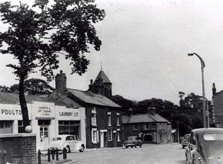
1 Vicarage Road is a Grade II listed building in the English market town of Poulton-le-Fylde, Lancashire. Built in 1839, it stands at the corner of Vicarage Road and Chapel Street. It directly across the latter from the Thatched House public house. Now an estate agent, the building was originally Poulton Savings Bank. It was the town's library in the 1880s.

Marsh Farmhouse is an historic building in Thornton-Cleveleys, Lancashire, England. Built in 1803, it is a Grade II listed building. It is located to the southeast of today's Amounderness Way roundabout at Victoria Road East.

Lytham St Annes Town Hall is a municipal building on the South Promenade in Lytham St Annes, Lancashire, England. The structure, which is used as the headquarters of Fylde Borough Council, is a locally listed building.

Jean Stansfield MemorialPark is an urban children's park in the English market town of Poulton-le-Fylde. It is located on Station Road, at its junction with Vicarage Road, one of the main roads leading to and from the town centre.
Queen's Square is a formerly open area in the centre of the English market town of Poulton-le-Fylde, Lancashire. It stands today, immediately to the southeast of Market Place, at the convergence of Blackpool Old Road to the west, Chapel Street and Higher Green to the east and Hardhorn Road to the south.
Market Place is a pedestrianised public square in the market town of Poulton-le-Fylde, Lancashire, England. Dating to the Middle Ages, it has historically been a site of weekly markets, today taking place on Mondays. It is now mostly used as a shopping precinct, along with the adjacent indoor Teanlowe Centre. It is bounded by Church Street to the north and Blackpool Old Road to the south.

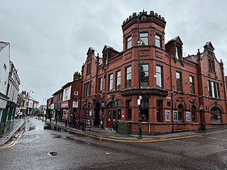
The Golden Ball is a public house and hotel on Ball Street in the English market town of Poulton-le-Fylde, Lancashire. Built in the 19th century, it was originally a coaching inn for travellers making their way to local towns and villages. During the course of its existence, the building has been a police courtroom, a newsroom and a café. Ball Street is named for the pub.

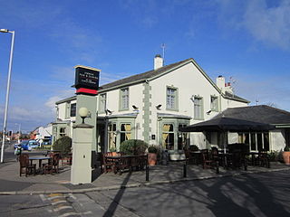
The Thatched House is a public house on Ball Street in the English market town of Poulton-le-Fylde, Lancashire. A former coaching inn, it stands adjacent to the churchyard of St Chad's, at the corner of Chapel Street. A tavern, believed to have been called the Green Man, was on the site in 1793, and may have been built in the Middle Ages.

The Bull is a public house on Blackpool Old Road in the English market town of Poulton-le-Fylde, Lancashire. The original pub, named The Black Bull Inn, was built in the 19th century and gave its name to the street on which it stood. Bull Street was renamed Blackpool Old Road in the 20th century. The pub, named the Bull Hotel, was rebuilt in 1963.

Church Street is a historic street in the market town of Poulton-le-Fylde, Lancashire, England. It runs for about 210 feet, from Ball Street in the north to Market Place in the south. An entrance to the Teanlowe Centre shopping precinct is located where Church Street merges into Market Place. The street was pedestrianised in 1983.
Breck Road is a road in Poulton-le-Fylde, Lancashire, England. Originally known as Breck Street, it runs for about 0.79 miles (1.27 km) from Chapel Street, Ball Street and Vicarage Road in the south to Amounderness Way in the north.

The Teanlowe Centre is a shopping centre in Poulton-le-Fylde, Lancashire, England. Completed in 1974, it is bounded by Tithebarn Street to the north, Church Street to the east, Blackpool Old Road to the south and Queensway to the west.
Samuel Lomas was an English clockmaker, active in the mid-to-late 18th century.

Tithebarn Street is a historic street in the market town of Poulton-le-Fylde, Lancashire, England. It runs for about 0.34 miles (0.55 km), from a convergence with Ball Street in the east to a convergence with Poulton Road in the west. Part of the B5267, it is one-way westbound from Ball Street to Queensway.