Kirkham is a town and civil parish in the Borough of Fylde in Lancashire, England, midway between Blackpool and Preston and adjacent to the smaller town of Wesham. It owes its existence to Carr Hill upon which it was built and which was the location of a Roman fort. At the census of 2011, it had a population 7,194.

Wyre is a local government district with borough status in Lancashire, England. The population of the non-metropolitan district at the 2011 census was 107,749. The district borders the unitary authority area of Blackpool as well as the districts of Lancaster, Ribble Valley, Fylde and Preston. The council is based in Poulton-le-Fylde. The district is named after the River Wyre, which runs through the district.

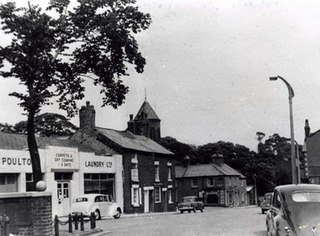
Poulton-le-Fylde, commonly shortened to Poulton, is a market town in Lancashire, England, situated on the coastal plain called the Fylde. In the 2021 United Kingdom census, it had a population of 18,115.
Thornton is a village in the Borough of Wyre, about 4 miles (6 km) north of Blackpool and 2 miles (3 km) south of Fleetwood. The civil parish of Thornton became an urban district in 1900, and was renamed Thornton-Cleveleys in 1927. In 2011 the Thornton built-up area sub division had a population of 18,941.
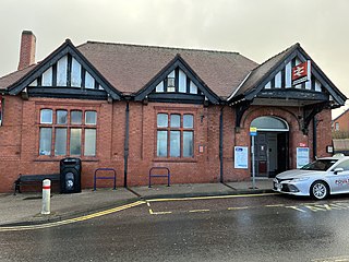
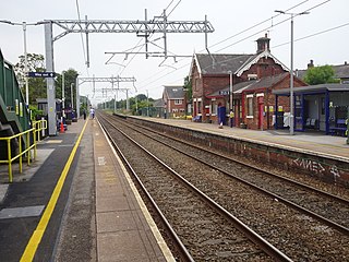
Poulton-le-Fylde railway station serves the town of Poulton-le-Fylde in Lancashire, England. It is managed by Northern Trains, but also served by Avanti West Coast and is 14+1⁄4 miles (22.9 km) northwest of Preston.
The Blackpool branch lines are two railway branch lines running from the West Coast Main Line at Preston to Blackpool: The main branch which is double track and electrified, runs to Blackpool North station via Poulton-le-Fylde. A second branch, which is single track and unelectrified, diverges from the main branch at Kirkham and Wesham junction, running on a southerly route to Blackpool South station via Lytham.
The Fleetwood branch line consists of the railway line from Preston to Fleetwood. It passed through many smaller stations along the way. When work at Fleetwood docks was under threat in the mid-1960s, the main Fleetwood station was closed; the remainder of the branch south to Poulton followed in 1970. Proposals exist to re-open the branch to passenger services in the near future.
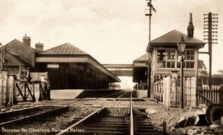
Thornton–Cleveleys was a railway station in England which served the Lancashire village of Thornton and town of Cleveleys. Located on the now disused line between Poulton-le-Fylde and Fleetwood, the station also had a shunting yard for the making-up of freight trains for Preston and beyond. During its life it was also known at times as Thornton station and Thornton for Cleveleys station. In the 1860s and early 1870s the line was of great importance, being the direct route from London to Glasgow. Before the Shap route was opened, passengers would travel from Euston to Fleetwood and then onwards via steamer to Scotland.
Great Eccleston is a village and civil parish in the English county of Lancashire, situated on a coastal plain called the Fylde. The village lies to the south of the River Wyre and the A586 road, approximately 10 miles (16 km) upstream from the port of Fleetwood. At the 2001 United Kingdom census, the parish had a population of 1,473, rising slightly to 1,486 at the Census 2011.
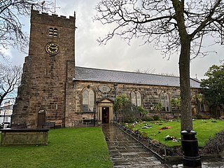
Poulton-le-Fylde is a market town in the Wyre district of Lancashire, England, situated on a coastal plain called the Fylde. There are 16 buildings and structures in the town which have been listed by the Secretary of State for Culture, Olympics, Media and Sport as being of special architectural, historical or cultural significance. One is classified as Grade II*, and the rest as Grade II; Poulton-le-Fylde has no Grade I listed buildings. The Grade II* designation is for St Chad's Church. There is written evidence of a church on the site since 1094, although it may have been built earlier. It became the Anglican parish church at the time of the Reformation and was largely rebuilt in the 18th century.
St Chad's Church is an Anglican church in Poulton-le-Fylde, Lancashire, England. It is an active parish church in the Diocese of Blackburn and the archdeaconry of Lancaster. It is recorded in the National Heritage List for England as a designated Grade II* listed building. A church on the site was built no later than the 11th century and may have existed prior to the Norman conquest of England. The tower dates from the 17th century, and much of the remainder of the building from a major renovation in the 18th century, although some of the fabric of the original structure remains. Further renovation and additions took place in the 19th, 20th and 21st centuries.

The Church of St John the Evangelist is a Roman Catholic church in the market town of Poulton-le-Fylde, Lancashire, England. The current church replaced an earlier chapel which lies a few metres to the north-east. The former chapel, with its attached presbytery, has been designated a Grade II listed building by English Heritage.
Marton is a settlement on the coastal plain of the Fylde in Lancashire, England, most of which is now part of the seaside town of Blackpool. Marton, which consisted of Great Marton, Little Marton, Marton Fold and The Peel, was originally part of the parish of Poulton-le-Fylde, before the development of Blackpool as a resort.
Carleton is a village on the coastal plain of the Fylde in the Borough of Wyre in Lancashire, England. It consists of Great Carleton, Little Carleton, Norcross and Whiteholme and is situated close to Poulton-le-Fylde. Other nearby settlements include Thornton, Bispham and Blackpool. Historically, Carleton was in the parish of Poulton-le-Fylde. It borders the Borough of Blackpool immediately to the west.

1 Vicarage Road is a Grade II listed building in the English market town of Poulton-le-Fylde, Lancashire. Built in 1839, it stands at the corner of Vicarage Road and Breck Road, directly across the latter from the Thatched House public house. Now an estate agent, the building was originally Poulton Savings Bank. It was the town's library in the 1880s.

Erected in 1921, the Poulton-le-Fylde War Memorial is located in the English market town of Poulton-le-Fylde, Lancashire. A Grade II listed structure, it stands in a small cobbled area at the north end of Market Place, having been moved from nearby Queen’s Square in 1979. Made of granite, it consists of a pillar with an octagonal foot, and a ball finial surmounted by a wheel-head cross. The pillar is on a square plinth on an octagonal step. On the plinth is a timber plaque with a coat of arms, a bronze plaque with an inscription, and further plaques recording the names of those lost in the World Wars and another conflict.

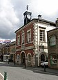
The Old Town Hall is a building on Church Street in the market town of Poulton-le-Fylde in Lancashire, England. The building, which is located at the northern end of Market Place, started life as a public house before becoming a municipal building and then reverting to use as a public house.
Queen's Square is a formerly open area in the centre of the English market town of Poulton-le-Fylde, Lancashire. It stands today, immediately to the southeast of Market Place, at the confluence of Blackpool Old Road to the west, Chapel Street and Higher Green to the east and Hardhorn Road to the south.

Market Place is a public square in the English market town of Poulton-le-Fylde, Lancashire. Dating to the Middle Ages, it has historically been a site of weekly markets, today taking place on Mondays. It is now mostly used as a shopping precinct, along with the adjacent indoor Teanlowe Centre.

The Golden Ball is a public house and hotel on Ball Street in the English market town of Poulton-le-Fylde, Lancashire. Built in the 19th century, it was originally a coaching inn for travellers making their way to local towns and villages. As of 2023, the three-storey building is owned by Greene King. It was formerly a Tetley's establishment.