Listed buildings in Fleetwood

Last updated

The Lower Lighthouse (1840), designed by Decimus Burton and engineered by Henry Mangles Denham The Lower Lighthouse - geograph.org.uk - 1454967.jpg
The Lower Lighthouse (1840), designed by Decimus Burton and engineered by Henry Mangles Denham

Fleetwood is a fishing and market town within the Wyre district of Lancashire, England, lying at the northwest corner of the Fylde coast. All of the 44  listed buildings are recorded in the National Heritage List for England at Grade II.

Contents

Fleetwood is a planned town of the Victorian era. In 1836, local landowner and Preston MP Peter Hesketh employed architect Decimus Burton to design the new town. Burton planned the town so that the main streets radiated from a slightly raised piece of land in the centre called the Mount. [1] The Mount was topped with a pagoda designed by Burton. The pagoda no longer exists but its replacement, a pavilion built in 1902, is listed at Grade II.

In the United Kingdom, the term "listed building" refers to a building or other structure officially designated as being of special architectural, historical or cultural significance. These buildings are in three grades: Grade I consists of buildings of outstanding architectural or historical interest; Grade II* includes particularly significant buildings of more than local interest; Grade II consists of buildings of special architectural or historical interest. Buildings in England are listed by the Secretary of State for Culture, Media and Sport on recommendations provided by English Heritage, which also determines the grading. [2]

Key

Map all coordinates using: OpenStreetMap
Explanation of the listed building grades
GradeCriteria [2]
Grade IIBuildings of national importance and special interest

Listed buildings

List of the buildings and structures with photographs, locations, year or time of earliest construction, descriptive notes, and listed building grade
Name and locationPhotographGradeDateDescription
1–9 Pharos Street
(odd numbers)
53°55′35″N3°00′27″W / 53.9263°N 3.0076°W / 53.9263; -3.0076 (1–9 Pharos Street)
Houses on Pharos Street, Fleetwood.JPG IIc. 1846These houses date from some time after 1845 and are the only remaining original buildings of a larger circus built around the Upper Lighthouse. They are constructed of red brick with pitched slate roofs and are on two storeys. Numbers 1, 5, 7 and 9 have doorways with rendered Tuscan frames. [3] [4] [5]
15 St Peter's Place
53°55′25″N3°00′37″W / 53.9236°N 3.0104°W / 53.9236; -3.0104 (15 St Peter's Place)
15 St Peter's Place, Fleetwood.jpg IIbetween 1841 and 1845This three-storey house was built between 1841 and 1845. It is constructed of red brick with ashlar dressings and has blue-grey slate roofs. There is a continuous sill plate across the front of number 15 and its neighbours at the first floor level; at the eaves there is a moulded cornice. [6] [7]
2–40 Mount Street
53°55′17″N3°00′47″W / 53.9215°N 3.0131°W / 53.9215; -3.0131 (2–40 Mount Street)
2-40 Mount Street, Fleetwood.jpg IIbetween 1836 and 1841These houses were built between 1836 and 1841 under the supervision of Decimus Burton. They are rendered, with modern tile roofs. They have two storeys and sash windows. [8]
16–20, 21–23, 24–29 Queen's Terrace
53°55′35″N3°00′24″W / 53.9264°N 3.0067°W / 53.9264; -3.0067 (21–23 Queen's Terrace)
Fleetwood - Mar 2008 - Queen's Terrace.jpg II1836–41This range of houses was built by 1841, designed by Decimus Burton. They are constructed of ashlar, with hipped roofs of slate. [9]
23–27 Lord Street
(odd numbers)
53°55′24″N3°00′33″W / 53.9234°N 3.0093°W / 53.9234; -3.0093 (23–27 Lord Street)
23-27 Lord Street, Fleetwood.JPG IImid-19th centuryThese houses were built in the mid-19th century. On three storeys, they are rendered. [10]
26 and 28 Dock Street
53°55′24″N3°00′22″W / 53.9233°N 3.0061°W / 53.9233; -3.0061 (26 and 28 Dock Street)
Lynn's Diner, Dock Street, Fleetwood.jpg IImid-19th centuryThis building dates from the mid-19th century. It is constructed of ashlar. It has three storeys and its pitched roof is of slate. [11]
29 Church Street
53°55′24″N3°00′34″W / 53.9233°N 3.0094°W / 53.9233; -3.0094 (29 Church Street)
National Westminster Bank, Church Street, Fleetwood - geograph.org.uk - 1401645 (cropped).jpg IIearly 20th centuryThis building dates from the early 20th century. It is constructed of ashlar. [12]
3 Kent Street
53°55′31″N3°00′24″W / 53.9254°N 3.0068°W / 53.9254; -3.0068 (3 Kent Street)
3 Kent Street, Fleetwood 3.jpg IImid-19th centuryThis house was built in the mid-19th century. It is constructed of red brick with a hipped roof of slate. It is on two storeys and has a canted corner. The sash windows have glazing bars on both sides. [13]
3–5 Queen's Terrace
53°55′28″N3°00′20″W / 53.9244°N 3.0056°W / 53.9244; -3.0056 (3–5 Queen's Terrace)
3-5 Queen's Terrace, Fleetwood.jpg II1836–39These houses were built by 1839 under the supervision of (and probably designed by) Decimus Burton. They are constructed of red brick with hipped roofs of slate. They are on two storeys and each have three ranges of sash windows. The front entrances have Tuscan frames. [14]
32 Lord Street
53°55′24″N3°00′36″W / 53.9234°N 3.0100°W / 53.9234; -3.0100 (32 Lord Street)
32 Lord Street, Fleetwood 2.jpg IImid-19th centuryThis building dates from the mid-19th century. It is constructed of rendered brick and has three storeys. [15]
32 North Albert Street
53°55′30″N3°00′30″W / 53.9251°N 3.0083°W / 53.9251; -3.0083 (32 North Albert Street)
32 North Albert Street, Fleetwood.jpg IImid-19th centuryThis building dates from the mid-19th century. It is constructed of red brick with the first floor rendered. Its pitched roof is of slate. The doorway has fluted Ionic columns. [16]
34 Warren Street
53°55′23″N3°00′36″W / 53.9230°N 3.0100°W / 53.9230; -3.0100 (34 Warren Street)
34 Warren Street, Fleetwood.jpg II1836–41This building was completed by 1841, under the supervision of (and probably designed by) Decimus Burton. It is rendered and has three storeys. There are two ranges of sash windows. [17]
45 and 47 Warren Street
53°55′23″N3°00′36″W / 53.9230°N 3.0101°W / 53.9230; -3.0101 (45 and 47 Warren Street)
45 and 47 Warren Street, Fleetwood.jpg IImid-19th centuryThis building dates from the mid-19th century. It is constructed of ashlar and has three storeys. [18]
50–96 Mount Street
53°55′22″N3°00′52″W / 53.9227°N 3.0145°W / 53.9227; -3.0145 (50–96 Mount Street)
50-90 Mount Street, Fleetwood.jpg II1836–41This range of houses was built 1836–41 under the supervision of (and probably designed by) Decimus Burton. they are constructed of red brick, and some are rendered. [19]
51–97 Mount Street
53°55′21″N3°00′53″W / 53.9224°N 3.0147°W / 53.9224; -3.0147 (51–97 Mount Street)
51-97 Mount Street, Fleetwood.jpg II1836–41This range of houses was built 1836–41 under the supervision of (and probably designed by) Decimus Burton. They are constructed of red brick and are rendered. [20]
8 Queen's Terrace
53°55′30″N3°00′21″W / 53.9249°N 3.0058°W / 53.9249; -3.0058 (8 Queen's Terrace)
8 Queen's Terrace, Fleetwood.jpg IIc. 1839This building was completed by 1839, under the supervision of (and probably designed by) Decimus Burton. It is constructed of red brick with a pitched roof of slate. It has two storeys, with three ranges of sash windows. [21]
Chaucer County Junior School and surrounding wall
53°55′22″N3°01′09″W / 53.9228°N 3.0191°W / 53.9228; -3.0191 (Chaucer School)
Chaucer Shcool, Fleetwood 2.JPG IIearly 20th centuryChaucer School was built in the early 20th century. It is constructed of red brick and its hipped roof is of tile. It has two storeys. The surrounding wall is red brick with terracotta coping. [22] [23]
Citizen's Advice Bureau
53°55′31″N3°00′55″W / 53.9252°N 3.0153°W / 53.9252; -3.0153 (Citizen's Advice Bureau)
Citizen's Advice Bureau, Mount Road, Fleetwood.JPG II1841This building dates from 1841, possibly designed by Decimus Burton. It serves as the entrance to The Mount Pavilion. it is constructed of ashlar; its pitched roof is modern, constructed of tile. The roof has overhanging eaves supported by wooden brackets. [24]
Drinking Fountain on East Side of Euston Park
53°55′42″N3°00′29″W / 53.9282°N 3.0080°W / 53.9282; -3.0080 (Drinking Fountain)
Cherub fountain, Fleetwood - geograph.org.uk - 429391.jpg IIlate 19th centuryThe drinking fountain was built in the late 19th century and is constructed of cast iron. It has a semi-circular bowl which sits on sphinxes. Above is a baluster, topped by a cherub. [3] [25]
Fleetwood Museum
53°55′29″N3°00′21″W / 53.9247°N 3.0058°W / 53.9247; -3.0058 (Fleetwood Museum)
Fleetwood Museum - DSC06604.JPG II1836This building dates from 1836, designed by Decimus Burton. It was the first building of the new town, originally the Customs House and now houses Fleetwood Museum. Built on two storeys, it is rendered with roughcast. It has eight ranges of sash windows. At the roof line there is a decorative iron parapet. The front entrances are through porticos which are flanked by Tuscan columns. [3] [26]
Fleetwood Museum and Public Library (former)
53°55′24″N3°00′23″W / 53.9233°N 3.0063°W / 53.9233; -3.0063 (Former Fleetwood Museum and Public Library)
Former Museum and Public Library, Fleetwood.jpg II1863The former museum and public library on Dock Street was built in 1863 to a design by Thomas Atkinson. It is constructed of red brick with ashlar dressings in the Venetian Gothic style. It is built on two storeys and has an ashlar parapet. [27] [28]
Fleetwood Working Men's Club
53°55′20″N3°00′36″W / 53.9221°N 3.0100°W / 53.9221; -3.0100 (Fleetwood Working Men's Club)
Working Men's Club, Fleetwood.jpg II1841–45This working men's club was built 1841–45. It is constructed of ashlar with a pitched roof of slate. [29]
LMR Sports and Social Club, Dock Street
53°55′19″N3°00′34″W / 53.9219°N 3.0095°W / 53.9219; -3.0095 (LMR Sports And Social Club 126)
LMR Sports and Social Club, Fleetwood.jpg II1836–41These buildings were completed by 1841, under the supervision of (and probably designed by) Decimus Burton. [30]
Lower Lighthouse
53°55′43″N3°00′33″W / 53.9285°N 3.0091°W / 53.9285; -3.0091 (Lower Lighthouse)
Beach Lighthouse, Fleetwood - DSC06584.JPG II1840The Lower Lighthouse was built 1840 to a design by Decimus Burton, engineered by Henry Mangles Denham. The light is 44 feet (13 m) above half-tide level. It is constructed of stone, in three stages. [31] [32]
The Mount Pavilion
53°55′33″N3°00′58″W / 53.9258°N 3.0161°W / 53.9258; -3.0161 (The Mount Pavilion)
The Mount, Fleetwood - DSC06569.JPG II1904This seaside pavilion was built in 1902 [1] or 1904. [33] It replaced a pagoda designed by Decimus Burton, around which he planned the layout of Fleetwood. The pavilion is constructed of roughcast brick with tile roofs. It has an octagonal dome with a copper roof.
North Euston Hotel
53°55′41″N3°00′33″W / 53.9280°N 3.0092°W / 53.9280; -3.0092 (North Euston)
North Euston Hotel, Fleetwood - DSC06585.JPG II1840–41This hotel was built 1840–41 to a design by Decimus Burton. It is constructed of ashlar with a slate roof that is hipped in the centre block, and mansard elsewhere. [34] [35]
Pennine View
53°55′20″N3°00′32″W / 53.9222°N 3.0090°W / 53.9222; -3.0090 (Pennine View)
Pennine View, Fleetwood 2.jpg IIbetween 1841 and 1845Pennine View, formerly the Crown Hotel, was built between 1841 and 1845 to a design by A. Tuach. It is constructed of ashlar with a modern roof. It has three storeys and a pilastered stone doorway. [27] [36]
Presbytery to St Mary's Church
53°55′21″N3°00′38″W / 53.9225°N 3.0106°W / 53.9225; -3.0106 (Presbytery to St Mary's Church)
St Mary's Presbytery, Fleetwood 2.jpg II1878The presbytery to the north of St Mary's was built in 1878, designed by Innocent and Brown of Sheffield. It is constructed of rock-faced stone with a pitched of slate. It has two storeys and a full-height canted bay with a hipped roof. [37] [38]
Prince Arthur Hotel
53°55′23″N3°00′39″W / 53.9231°N 3.0107°W / 53.9231; -3.0107 (Prince Arthur Hotel)
The 'Prince Arthur', Lord Street, Fleetwood - geograph.org.uk - 1401658.jpg IImid-19th centuryThe Prince Arthur Hotel was built in the mid-19th century. It is constructed of red brick and has painted ashlar dressings. Its pitched roof is slate. [39]
Radar Training Station
Radar station, Fleetwood - DSC06583.JPG II1961–62The Radar Training Station was built 1961–62 [40] or 1964–65 [34] to a design by the Lancashire County Council Architect's Department. The project architect was Eric Morris Hart. It is constructed of reinforced concrete.
Rossall School Chapel
53°53′41″N3°02′42″W / 53.8946°N 3.0450°W / 53.8946; -3.0450 (Rossall School Chapel)
RossallSchoolChapel1.jpg II1861–62This chapel of Saint John the Evangelist was built 1861–62 to a design by Edward Graham Paley. It is constructed of hammer-dressed stone with ashlar dressings. [41] [42]
East Range of Quadrangle at Rossall School
53°53′45″N3°02′38″W / 53.8957°N 3.0440°W / 53.8957; -3.0440 (East Range of Quadrangle at Rossall School)
Rossall School, Fleetwood - geograph.org.uk - 382019.jpg II1867This range was built in 1867 to a design by Edward Graham Paley. [43]
Falcon House, Rossall School
53°53′48″N3°02′35″W / 53.8966°N 3.0430°W / 53.8966; -3.0430 (Falcon House)
IImid-19th centuryThis building dates from the mid-19th century. it is constructed of red brick, with a pitched roof of slate. It has two storeys. [44]
Rossall School Gazebo and wall leading south from the gazebo
53°53′43″N3°02′44″W / 53.8952°N 3.0455°W / 53.8952; -3.0455 (Rossall School Gazebo)
RossallGazebo.jpg IIearly 18th centuryThe gazebo with attached wall was built in the early 18th century, designed by either Richard (d. 1709) or Edward Fleetwood (d. 1757). It is constructed of red brick, with ashlar dressings. [45] [46]
Rossall School Library
53°53′45″N3°02′41″W / 53.8957°N 3.0448°W / 53.8957; -3.0448 (Rossall School Library)
SumnerLibrary.jpg II1850The Sumner Library, formerly a chapel, was built in 1850 to a design by J. E. Gregan of Manchester. It is constructed of hammer-dressed stone with ashlar dressings. [47] [48]
North Range of Quadrangle at Rossall School
53°53′46″N3°02′43″W / 53.8961°N 3.0453°W / 53.8961; -3.0453 (North Range of Quadrangle at Rossall School)
Rossall School, Fleetwood - geograph.org.uk - 382019.jpg II1853This range was built in 1853 to a design by Edward Graham Paley. [49]
West Range of Quadrangle at Rossall School
53°53′45″N3°02′45″W / 53.8958°N 3.0457°W / 53.8958; -3.0457 (West Range of Quadrangle at Rossall School)
Rossall School, Fleetwood - geograph.org.uk - 382013.jpg IIc. 1885–90This range was built c. 1885–90 to a design by Edward Graham Paley, Hubert Austin and Henry Paley. [50]
St Mary's Church
53°55′22″N3°00′38″W / 53.9227°N 3.0105°W / 53.9227; -3.0105 (St Mary's Church)
Fleetwood - Mar 2008 - St May's RC Church, Lord St.jpg II1866–67St Mary's was built 1866–67 to a design by Edward Welby Pugin. It is constructed of rockfaced stone with ashlar dressings and has pitched roofs of slate. Its nave and chancel are under one roof and there is no tower. [51] [52]
St Peter's Church
53°55′26″N3°00′34″W / 53.9239°N 3.0094°W / 53.9239; -3.0094 (St Peter's Church)
Fleetwood - Mar 2008 - St Peter's Parish Church.jpg II1840–41St Peter's Church was built 1840–41 to a design by Decimus Burton. It is constructed of rock-faced stone, with ashlar dressings. It was remodelled in 1883 by Paley and Austin. [53]
Upper Lighthouse
53°55′35″N3°00′27″W / 53.9265°N 3.0075°W / 53.9265; -3.0075 (Upper Lighthouse)
PharosFwdJun2004.jpg II1840Built 1839–40 probably to a design by Decimus Burton. It is constructed of red sandstone with ashlar dressings. [3] [54]
Victoria Public House
53°55′24″N3°00′24″W / 53.9232°N 3.0066°W / 53.9232; -3.0066 (58–62 Dock Street)
Victoria Pub, Fleetwood.jpg II1836–41This range of shops was completed by 1841, under the supervision of (and probably designed by) Decimus Burton. They are rendered, and on three storeys. [27] [55]
War Memorial
53°55′08″N3°01′24″W / 53.9190°N 3.0234°W / 53.9190; -3.0234 (War Memorial)
Fleetwood War Memorial 4.jpg II1927The war memorial in Memorial Park dates from 1927. [34] [56]
Memorial Park Gateway
53°55′10″N3°01′15″W / 53.91953°N 3.0209°W / 53.91953; -3.0209 (Memorial Park Gate)
Memorial Park Entrance, Fleetwood.jpg II1902The gates were added to the gateway in 1926. The gateway consists of a rendered brick triumphal arch in Baroque style. There is a large central arch, flanked by smaller arches, and there is a balustrade over the central arch. [34] [57]
St Nicholas Church
53°55′07″N3°01′48″W / 53.91866°N 3.03011°W / 53.91866; -3.03011 (St Nicholas Church)
Fleetwood - Mar 2008 - St Nicholas Church, Broadway.jpg II1960–62The church is in red brick with a timber-slatted gable and a copper-clad roof. It consists of a central pylon-like tower, a nave with side aisles incorporating vestries, porches and a chancel. On each side of the nave are three triangular dormers, and there are three similar, smaller dormers on the chancel. [37] [58]

See also

Related Research Articles

<span class="mw-page-title-main">Poulton-le-Fylde</span> Human settlement in England

Poulton-le-Fylde, commonly shortened to Poulton, is a market town in Lancashire, England, situated on the coastal plain called the Fylde. In the 2021 United Kingdom census, it had a population of 18,115.

<span class="mw-page-title-main">Fleetwood</span> Town in Lancashire, England

Fleetwood is a coastal town in the Borough of Wyre in Lancashire, England, at the northwest corner of the Fylde. It had a population of 25,939 at the 2011 census.

<span class="mw-page-title-main">Pharos Lighthouse, Fleetwood</span> Lighthouse

The Pharos Lighthouse is a 93-foot (28 m) tall Runcorn red sandstone lighthouse situated in Fleetwood, Lancashire, England. The lighthouse was designed in 1839 by Decimus Burton and Capt H.M. Denham. Burton has been commissioned three years previously by Sir Peter Hesketh Fleetwood as the architect of the new town of Fleetwood. Construction was completed in 1840. Unusually for a functioning British lighthouse, it stands in the middle of a residential street. Though officially named the 'Upper Lighthouse', it has been known as the 'Pharos' since its construction, after the celebrated ancient lighthouse Pharos of Alexandria.

<span class="mw-page-title-main">Listed buildings in Poulton-le-Fylde</span>

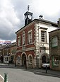
Poulton-le-Fylde is a market town in the Wyre district of Lancashire, England, situated on a coastal plain called the Fylde. There are 16 buildings and structures in the town which have been listed by the Secretary of State for Culture, Olympics, Media and Sport as being of special architectural, historical or cultural significance. One is classified as Grade II*, and the rest as Grade II; Poulton-le-Fylde has no Grade I listed buildings. The Grade II* designation is for St Chad's Church. There is written evidence of a church on the site since 1094, although it may have been built earlier. It became the Anglican parish church at the time of the Reformation and was largely rebuilt in the 18th century.

<span class="mw-page-title-main">St Peter's Church, Fleetwood</span> Church in Lancashire, England

St Peter's Church is in the seaside town of Fleetwood, Lancashire, England, situated on the Fylde coast. It is an active Anglican parish church in the Diocese of Blackburn. It was completed in 1841, to a design by Decimus Burton. Burton had been employed by Peter Hesketh-Fleetwood in 1836 to lay out the new planned town of Fleetwood. It is protected as a Grade II listed building.

<span class="mw-page-title-main">Marsh Mill</span>

Marsh Mill is an 18th-century tower windmill in Thornton, Lancashire, England. It was built in 1794 by Ralph Slater for local landowner Bold Hesketh. It functioned as a corn mill until the 1920s and has been fully restored. It is a good example of a complete English windmill and has been designated a Grade II* listed building.

<span class="mw-page-title-main">St Helen's Church, Churchtown</span> Church in Churchtown, Lancashire

St Helen's Church is an Anglican church in the village of Churchtown in Lancashire, England. Historically, it was the parish church of Garstang; today, as Garstang is split into more than one ecclesiastical parish, St Helen's parish is Garstang St Helen (Churchtown). It is in the Diocese of Blackburn. It has been designated a Grade I listed building by English Heritage. St Helen's is known as the "cathedral of The Fylde".

<span class="mw-page-title-main">Fleetwood Museum</span> Municipal building in Fleetwood, Lancashire, England

Fleetwood Museum is a local history and maritime museum in the English seaside town of Fleetwood, Lancashire. The museum was originally the town's Customs House and, completed in 1836, was one of the first buildings constructed in Fleetwood. Like much of the town it was designed by architect Decimus Burton. The building became the local town hall and is now a maritime museum. It has been designated a Grade II listed building by Historic England.

<span class="mw-page-title-main">North Euston Hotel</span> Building in Lancashire, England

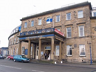
The North Euston Hotel is a hotel in Fleetwood, Lancashire, England. It was built 1840–41, to a design by Decimus Burton. During the second half of the 19th century, the building was used by the War Department as a School of Musketry; by the end of the century it had reverted to its original purpose. The hotel has been designated a Grade II listed building by English Heritage.

Ribchester is a civil parish in Ribble Valley, Lancashire, England. It contains 23 listed buildings that are recorded in the National Heritage List for England. Of these, one is listed at Grade I, the highest of the three grades, one is at Grade II*, the middle grade, and the others are at Grade II, the lowest grade. The parish contains the village of Ribchester, and surrounding countryside. Most of the listed buildings are houses and associated structures, or farmhouses and farm buildings, some of which are in the village, and others are in the rural area. The other listed buildings are two churches, a presbytery, a sundial, a public house with a mounting block outside, a bridge, and almshouses with a wellhead in the grounds.

Barnacre-with-Bonds is a civil parish in the Wyre district of Lancashire, England. It contains 24 listed buildings that are recorded in the National Heritage List for England. All the listed buildings are designated at Grade II, the lowest of the three grades, which is applied to "buildings of national importance and special interest". The parish contains the settlements of Bonds, Calder Vale, and Bowgreave and is otherwise rural. The Lancaster Canal, the River Wyre and its tributary the River Calder pass through the parish and many of the bridges crossing them are listed. Also listed is the aqueduct carrying the canal over the River Wyre. The other listed buildings include farmhouses and other houses, churches, a Quaker meeting house, a former sawmill, a milestone, and a pump in a farmyard,

Inskip-with-Sowerby is a civil parish in the Wyre district of Lancashire, England. It contains six listed buildings that are recorded in the National Heritage List for England. All the listed buildings are designated at Grade II, the lowest of the three grades, which is applied to "buildings of national importance and special interest". The parish includes the village of Inskip and surrounding countryside. The listed buildings are two houses, two farmhouses, a former workshop, and a church.

Nether Wyresdale is a civil parish in the Wyre district of Lancashire, England. It contains 23 listed buildings that are recorded in the National Heritage List for England. All the listed buildings are designated at Grade II, the lowest of the three grades, which is applied to "buildings of national importance and special interest". The parish includes the villages of Scorton, the southern part of the village of Dolphinholme, and the countryside between and around them. Most of the listed buildings are houses, cottages, country houses and associated structures, and farmhouses. Also listed are a medieval cross base, a milestone, bridges, and churches and associated structures.

Out Rawcliffe is a civil parish in the Wyre district of Lancashire, England. It contains five listed buildings that are recorded in the National Heritage List for England. All the listed buildings are designated at Grade II, the lowest of the three grades, which is applied to "buildings of national importance and special interest". The parish, which is almost completely rural, contains the small village of Out Rawcliffe. The listed buildings consist of a farmhouse, a country house, a church, a former vicarage, and an animal pound.

Preesall is a civil parish in the Wyre district of Lancashire, England. It contains six buildings that are recorded in the National Heritage List for England as designated listed buildings. Of these, one is at Grade II*, the middle grade, and the others are at Grade II, the lowest grade. The parish includes the villages of Preesall and Knott End-on-Sea and the surrounding countryside. The listed buildings comprise three houses, a former mill, and a church.

Upper Rawcliffe-with-Tarnacre is a civil parish in the Wyre district of Lancashire, England. It contains nine buildings that are recorded in the National Heritage List for England as designated listed buildings. Of these, one is listed at Grade I, the highest of the three grades, and the others are at Grade II, the lowest grade. The parish includes the village of St Michael's on Wyre and is otherwise rural. The River Wyre passes through the parish, and a bridge crossing it is listed. The other listed buildings are a church and associated mounting block, a country house, a pair of gate piers, a war memorial, two milestones, and a combined milestone and boundary stone.

Winmarleigh is a civil parish in the Wyre district of Lancashire, England. It contains two listed buildings that are recorded in the National Heritage List for England. Both the listed buildings are designated at Grade II, the lowest of the three grades, which is applied to "buildings of national importance and special interest". Other than the village of Winmarleigh, the parish is rural. The listed buildings are a public house and a church.

<span class="mw-page-title-main">Marsh Farmhouse</span> Historic site in Lancashire, England

Marsh Farmhouse is an historic building in Thornton-Cleveleys, Lancashire, England. Built in 1803, it is a Grade II listed building. It is located to the southeast of today's Amounderness Way roundabout at Victoria Road West.

<span class="mw-page-title-main">Hackensall Hall</span> Building in Preesall, Lancashire, England

Hackensall Hall, also known as Hackensall Hall Farmhouse, is an historic building on Whinny Lane in Preesall, Lancashire, England. It is Grade II listed, built in 1873.

References

Footnotes
  1. 1 2 Hartwell & Pevsner (2009), p. 298
  2. 1 2 Listed Buildings, English Heritage, 2010, archived from the original on 26 January 2013, retrieved 23 August 2011
  3. 1 2 3 4 Hartwell & Pevsner (2009), p. 296
  4. Taylor & Payne (2008), p. 40
  5. Historic England, "1–9, Pharos Street (1163480)", National Heritage List for England , retrieved 19 June 2011
  6. Taylor & Payne (2008), p. 55
  7. Historic England, "15, St Peter's Place (1163518)", National Heritage List for England , retrieved 19 June 2011
  8. Historic England, "2–40, Mount Street (1362186)", National Heritage List for England , retrieved 19 June 2011
  9. Historic England, "16–20, Queen's Terrace (1362188)", National Heritage List for England , retrieved 19 June 2011
  10. Historic England, "23–27, Lord Street (1072391)", National Heritage List for England , retrieved 19 June 2011
  11. Historic England, "26 and 28, Dock Street (1072427)", National Heritage List for England , retrieved 19 June 2011
  12. Historic England, "29, Church Street (1362183)", National Heritage List for England , retrieved 19 June 2011
  13. Historic England, "3, Kent Street (1362182)", National Heritage List for England , retrieved 19 June 2011
  14. Historic England, "3–5, Queen's Terrace (1362187)", National Heritage List for England , retrieved 19 June 2011
  15. Historic England, "32, Lord Street (1163380)", National Heritage List for England , retrieved 19 June 2011
  16. Historic England, "32, North Albert Street (1318247)", National Heritage List for England , retrieved 19 June 2011
  17. Historic England, "34, Warren Street (1072399)", National Heritage List for England , retrieved 19 June 2011
  18. Historic England, "45 and 47, Warren Street (1072392)", National Heritage List for England , retrieved 19 June 2011
  19. Historic England, "50–96 Mount Street (1072396)", National Heritage List for England , retrieved 19 June 2011
  20. Historic England, "51–97 Mount Street (1163434)", National Heritage List for England , retrieved 19 June 2011
  21. Historic England, "8, Queen's Terrace (1163506)", National Heritage List for England , retrieved 19 June 2011
  22. Historic England, "Chaucer County Junior School, Milton Street (1362185)", National Heritage List for England , retrieved 19 June 2011
  23. Historic England, "Wall Round North, East and South Sides of Playground of Chaucer County Junior School, Milton Street (1163397)", National Heritage List for England , retrieved 19 June 2011
  24. Historic England, "Citizen's Advice Bureau, Mount Road (1072395)", National Heritage List for England , retrieved 19 June 2011
  25. Historic England, "Drinking Fountain on East Side of Euston Park (1072388)", National Heritage List for England , retrieved 19 June 2011
  26. Historic England, "Wyre Borough Treasurer's and Borough Housing Departments (1072398)", National Heritage List for England , retrieved 19 June 2011
  27. 1 2 3 Hartwell & Pevsner (2009), p. 297
  28. Historic England, "Fleetwood Museum and Public Library (1072428)", National Heritage List for England , retrieved 19 June 2011
  29. Historic England, "Fleetwood Working Men's Club (1072389)", National Heritage List for England , retrieved 19 June 2011
  30. Historic England, "Club Sylvana LMR Sports and Social Club (1072387)", National Heritage List for England , retrieved 19 June 2011
  31. Hartwell & Pevsner (2009), pp. 295–96
  32. Historic England, "Lower Lighthouse, Esplanade (1362180)", National Heritage List for England , retrieved 19 June 2011
  33. Historic England, "The Mount Pavilion, Esplanade (1072400)", National Heritage List for England , retrieved 19 June 2011
  34. 1 2 3 4 Hartwell & Pevsner (2009), p. 295
  35. Historic England, "North Euston Hotel, Euston Crescent (1362181)", National Heritage List for England , retrieved 19 June 2011
  36. Historic England, "Pennine View, Dock Street (1072430)", National Heritage List for England , retrieved 19 June 2011
  37. 1 2 Hartwell & Pevsner (2009), p. 293
  38. Historic England, "Presbytery to Roman Catholic Church of St Mary (1072390)", National Heritage List for England , retrieved 19 June 2011
  39. Historic England, "Prince Arthur Hotel (1072394)", National Heritage List for England , retrieved 19 June 2011
  40. Historic England, "Radar Training Station (1350338)", National Heritage List for England , retrieved 19 June 2011
  41. Hartwell & Pevsner (2009), p. 583
  42. Historic England, "Rossall School Chapel, Broadway (1362162)", National Heritage List for England , retrieved 19 June 2011
  43. Historic England, "East Range of Quadrangle at Rossall School (1072424)", National Heritage List for England , retrieved 19 June 2011
  44. Historic England, "Falcon House (block North of James House at Rossall School (1072426)", National Heritage List for England , retrieved 19 June 2011
  45. Historic England, "The Gazebo at Rossall School (1072421)", National Heritage List for England , retrieved 19 June 2011
  46. Historic England, "Wall Leading South From the Gazebo at Rossall School (1072422)", National Heritage List for England , retrieved 19 June 2011
  47. Hartwell & Pevsner (2009), p. 582
  48. Historic England, "Rossall School Library, Broadway (1362161)", National Heritage List for England , retrieved 19 June 2011
  49. Historic England, "North Range of Quadrangle at Rossall School (1072423)", National Heritage List for England , retrieved 19 June 2011
  50. Historic England, "West Range of Quadrangle at Rossall School (1072425)", National Heritage List for England , retrieved 19 June 2011
  51. Historic England, "Roman Catholic Church of St Mary (1362184)", National Heritage List for England , retrieved 19 June 2011
  52. Hartwell & Pevsner (2009), pp. 292–93
  53. Historic England, "Parish Church of St Peter, Lord Street (1072393)", National Heritage List for England , retrieved 19 June 2011
  54. Historic England, "Upper Lighthouse or Pharos (1072397)", National Heritage List for England , retrieved 19 June 2011
  55. Historic England, "Victoria Public House (1072429)", National Heritage List for England , retrieved 16 June 2011
  56. Historic England, "War Memorial (1116884)", National Heritage List for England , retrieved 16 June 2011
  57. Historic England, "Fleetwood Memorial Park Gate (1403509)", National Heritage List for England , retrieved 16 July 2016
  58. Historic England, "Church of St Nicholas (1487414)", National Heritage List for England , retrieved 3 November 2023
Bibliography

Commons-logo.svg Media related to Buildings in Fleetwood at Wikimedia Commons