Hackensall Hall

Last updated

Hackensall Hall
Hackensall Hall - geograph.org.uk - 2515303.jpg
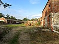
The building in 2011, looking south
LocationWhinny Lane, Preesall,
Lancashire,
England
Coordinates 53°55′14″N2°59′35″W / 53.92057°N 2.99317°W / 53.92057; -2.99317 Coordinates: 53°55′14″N2°59′35″W / 53.92057°N 2.99317°W / 53.92057; -2.99317
Area Borough of Wyre
Built1873(150 years ago) (1873)
Listed Building – Grade II
Designated3 October 1984
Reference no. 1361845
Location map United Kingdom Borough of Wyre.svg
Red pog.svg
Location of Hackensall Hall in the Borough of Wyre
Lancashire UK location map.svg
Red pog.svg
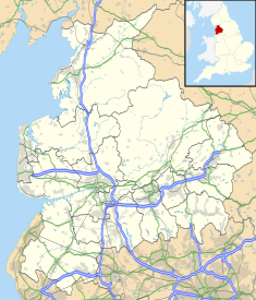
Hackensall Hall (Lancashire)

Hackensall Hall, also known as Hackensall Hall Farmhouse, is an historic building on Whinny Lane in Preesall, Lancashire, England. It is Grade II listed, built in 1873. [1]

Contents

A remodelling of a 17th-century house, it retains much of its earlier fabric. It is in pebbledashed brick with sandstone dressings and a slate roof, and has two storeys with attics. The house has an irregular plan with rear wings and outshuts. Most of the windows are mullioned and transomed, or mullioned. Other features include a single-storey gabled porch, a doorway with a moulded surround and a Tudor arched head, and a re-set inscribed plaque. Inside the house is an inglenook. [2] [1]

Francis Fleetwood, brother of Richard, built Hackensall Hall in 1656 after their home at Rossall Hall was flooded. [3] Nearby Parrox Hall was built about the same time, and has been in the possession of the Elletson family since 1690. [4]

Dorothy Parkinson

Dorothy Parkinson, who created the first example of Preesall salt, lived at the farm up until her death in 1925. She raised nine children there.

In 1926, Parkinson's husband, John, found over three hundred Roman coins in the hall's grounds. They were estimated to date to around 273 AD. [5]

Architectural detail

Farm buildings

See also

Related Research Articles

<span class="mw-page-title-main">Poulton-le-Fylde</span> Human settlement in England

Poulton-le-Fylde, commonly shortened to Poulton, is a market town in Lancashire, England, situated on the coastal plain called the Fylde. In the 2021 United Kingdom census, it had a population of 18,115.

<span class="mw-page-title-main">Elswick, Lancashire</span> Human settlement in England

Elswick is a rural village and civil parish on the Fylde coast of Lancashire, England. At the 2011 Census, it had a population of 1,079.

<span class="mw-page-title-main">Singleton, Lancashire</span> Human settlement in England

Singleton is a village and civil parish in Lancashire, England. It is situated on the coastal plain called the Fylde. It is located south-east of Poulton-le-Fylde, and at the 2001 census had a population of 877, increasing to 889 at the 2011 Census. The parish is sometimes referred to as two parts – Great Singleton is the larger part containing the village, and Little Singleton is a small area north of the village bordering the River Wyre.

<span class="mw-page-title-main">Great Eccleston</span> Human settlement in England

Great Eccleston is a village and civil parish in the English county of Lancashire, situated on a coastal plain called the Fylde. The village lies to the south of the River Wyre and the A586 road, approximately 10 miles (16 km) upstream from the port of Fleetwood. At the 2001 United Kingdom census, the parish had a population of 1,473, rising slightly to 1,486 at the Census 2011.

<span class="mw-page-title-main">Listed buildings in Poulton-le-Fylde</span>

Poulton-le-Fylde is a market town in the Wyre district of Lancashire, England, situated on a coastal plain called the Fylde. There are 16 buildings and structures in the town which have been listed by the Secretary of State for Culture, Olympics, Media and Sport as being of special architectural, historical or cultural significance. One is classified as Grade II*, and the rest as Grade II; Poulton-le-Fylde has no Grade I listed buildings. The Grade II* designation is for St Chad's Church. There is written evidence of a church on the site since 1094, although it may have been built earlier. It became the Anglican parish church at the time of the Reformation and was largely rebuilt in the 18th century.

<span class="mw-page-title-main">Carleton, Lancashire</span> Human settlement in England

Carleton is a village on the coastal plain of the Fylde in the Borough of Wyre in Lancashire, England. It consists of Great Carleton, Little Carleton, Norcross and Whiteholme and is situated close to Poulton-le-Fylde. Other nearby settlements include Thornton, Bispham and Blackpool. Historically, Carleton was in the parish of Poulton-le-Fylde. It borders the Borough of Blackpool immediately to the west.

<span class="mw-page-title-main">St Peter's Church, Fleetwood</span> Church in Lancashire, England

St Peter's Church is in the seaside town of Fleetwood, Lancashire, England, situated on the Fylde coast. It is an active Anglican parish church in the Diocese of Blackburn. It was completed in 1841, to a design by Decimus Burton. Burton had been employed by Peter Hesketh-Fleetwood in 1836 to lay out the new planned town of Fleetwood. It is protected as a Grade II listed building.

<span class="mw-page-title-main">Marsh Mill</span>

Marsh Mill is an 18th-century tower windmill in Thornton, Lancashire, England. It was built in 1794 by Ralph Slater for local landowner Bold Hesketh. It functioned as a corn mill until the 1920s and has been fully restored. It is a good example of a complete English windmill and has been designated a Grade II* listed building.

<span class="mw-page-title-main">Fleetwood Museum</span> Municipal building in Fleetwood, Lancashire, England

Fleetwood Museum is a local history and maritime museum in the English seaside town of Fleetwood, Lancashire. The museum was originally the town's Customs House and, completed in 1836, was one of the first buildings constructed in Fleetwood. Like much of the town it was designed by architect Decimus Burton. The building became the local town hall and is now a maritime museum. It has been designated a Grade II listed building by Historic England.

<span class="mw-page-title-main">North Euston Hotel</span> Building in Lancashire, England

The North Euston Hotel is a hotel in Fleetwood, Lancashire, England. It was built 1840–41, to a design by Decimus Burton. During the second half of the 19th century, the building was used by the War Department as a School of Musketry; by the end of the century it had reverted to its original purpose. The hotel has been designated a Grade II listed building by English Heritage.

Inskip-with-Sowerby is a civil parish in the Wyre district of Lancashire, England. It contains six listed buildings that are recorded in the National Heritage List for England. All the listed buildings are designated at Grade II, the lowest of the three grades, which is applied to "buildings of national importance and special interest". The parish includes the village of Inskip and surrounding countryside. The listed buildings are two houses, two farmhouses, a former workshop, and a church.

Preesall is a civil parish in the Wyre district of Lancashire, England. It contains six buildings that are recorded in the National Heritage List for England as designated listed buildings. Of these, one is at Grade II*, the middle grade, and the others are at Grade II, the lowest grade. The parish includes the villages of Preesall and Knott End-on-Sea and the surrounding countryside. The listed buildings comprise three houses, a former mill, and a church.

<span class="mw-page-title-main">Raikes Farmhouse</span> Historic site in Lancashire, England

Raikes Farmhouse is an historic building in Thornton-Cleveleys, Lancashire, England. Replacing a building dating from at least 1595, the current structure was built in 1692, with a rear extension added in the 19th century. It has been designated a Grade II listed building by Historic England. The property is located on Raikes Road, just southeast of its junction with Stanah Road and Hillylaid Road.

<span class="mw-page-title-main">The Olde Ship</span> Historic site in Lancashire, England

The Olde Ship is an historic building in Pilling, Lancashire, England. It was built in 1782 for sea captain and slave trader George Dickinson (1732–1806), and has been designated a Grade II listed building by Historic England.

<span class="mw-page-title-main">1 Vicarage Road</span> Building in Poulton-le-Fylde, Lancashire, England

1 Vicarage Road is a Grade II listed building in the English market town of Poulton-le-Fylde, Lancashire. Built in 1839, it stands at the corner of Vicarage Road and Breck Road, directly across the latter from the Thatched House public house. Now an estate agent, the building was originally Poulton Savings Bank. It was the town's library in the 1880s.

<span class="mw-page-title-main">Marsh Farmhouse</span> Historic site in Lancashire, England

Marsh Farmhouse is an historic building in Thornton-Cleveleys, Lancashire, England. Built in 1803, it is a Grade II listed building. It is located to the southeast of today's Amounderness Way roundabout at Victoria Road West.

<span class="mw-page-title-main">Claughton Hall</span> Country house in Lancashire, England

Claughton Hall is a large country house in the English village of Claughton, Lancashire. A Grade I listed building, it dates to around 1600, but it contains material believed to be from the 15th century.

<span class="mw-page-title-main">Black Bull, Preesall</span> Pub in Lancashire, England

The Black Bull, formerly known as the Black Bull Inn and Black Bull Hotel, is a public house in Preesall, Lancashire, England. Dating to 1762, it stands on Park Lane.

<span class="mw-page-title-main">Dorothy Parkinson</span>

Dorothy Parkinson was an English woman who created the first example of Preesall salt in 1872.

<span class="mw-page-title-main">Four Lane Ends, Lancashire</span> Junction in Thornton-Cleveleys, England

Four Lane Ends is a road junction in Thornton-Cleveleys, Lancashire, England. It is formed by the meeting of the north–south-running Fleetwood Road and the east–west-bound Victoria Road, the B5412. The names of both roads change in line with their directions at the junction, with Fleetwood Road North becoming Fleetwood Road South and Victoria Road East becomes Victoria Road West.

References

  1. 1 2 Historic England & 1361845
  2. Hartwell & Pevsner (2009), p. 360
  3. Porter, John (1876). History of the Fylde of Lancashire. W. Porter.
  4. A History of Blackpool, the Fylde and South Wyre – Nick Moore (2018), p. 63
  5. A History of Blackpool, the Fylde and South Wyre – Nick Moore (2018), p. 1263

Sources