Kirkham aka Kirkam-in-Amounderness is a market town and civil parish in the Borough of Fylde in Lancashire, England, midway between Blackpool and Preston and adjacent to the town of Wesham. It owes its existence to Carr Hill upon which it was built and which was the location of a Roman fort. At the census of 2011, it had a population 3,304 plus 3,890, giving a total of 7,194. By the census of 2021 the total had risen to 3,217 plus 4,666, giving a total of 7,883.

Wyre is a local government district with borough status on the coast of Lancashire, England. The council is based in Poulton-le-Fylde and the borough also contains the towns of Cleveleys, Fleetwood, Garstang, Preesall and Thornton, along with numerous villages and surrounding rural areas. Some of the borough's built-up areas form part of the wider Blackpool urban area. Eastern parts of the borough lie within the Forest of Bowland, a designated Area of Outstanding Natural Beauty.

Poulton-le-Fylde, commonly shortened to Poulton, is a market town in Lancashire, England, situated on the coastal plain called the Fylde. In the 2021 United Kingdom census, it had a population of 18,115.

Burn Naze is a residential area of Thornton-Cleveleys, in the Borough of Wyre, Lancashire, England. It is located about 5 miles (8 km) northeast of Blackpool and 2 miles (3 km) southeast of Fleetwood. Cleveleys is about 1.3 miles (2.1 km) to the west, while the River Wyre is about 0.8 miles (1.3 km) to the east.
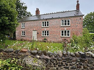
Raikes Farmhouse is an historic building in Thornton-Cleveleys, Lancashire, England. Replacing a building dating from at least 1595, the current structure was built in 1692, with a rear extension added in the 19th century. It has been designated a Grade II listed building by Historic England. The property is located on Raikes Road, just southeast of its junction with Stanah Road and Hillylaid Road.

Wardleys was a pub on Wardley's Lane in the civil parish of Stalmine-with-Staynall, near the village of Hambleton, Lancashire. The building dated to the 18th century and occupied a location, on the eastern banks of the River Wyre and beside Wardleys Creek, believed to have been used since Roman times. Prior to nearby Fleetwood's emergence as a harbour, people emigrated to the Americas from the creek, including aboard the Quebec-bound Six Sisters on 3 April 1833. The harbour's foundation rocks are still visible beneath today's wooden jetty. A ferry used to run from Cockle Hall, on the western side of the river, to Wardleys Creek. Parts of the pier are still visible in the marsh in front of where Cockle Hall once stood.

1 Vicarage Road is a Grade II listed building in the English market town of Poulton-le-Fylde, Lancashire. Built in 1839, it stands at the corner of Vicarage Road and Chapel Street. It directly across the latter from the Thatched House public house. Now an estate agent, the building was originally Poulton Savings Bank. It was the town's library in the 1880s.

Erected in 1921, the Poulton-le-Fylde War Memorial is located in the English market town of Poulton-le-Fylde, Lancashire. A Grade II listed structure, it stands in a small cobbled area at the north end of Market Place, having been moved from nearby Queen's Square in 1979. Made of granite, it consists of a pillar with an octagonal foot, and a ball finial surmounted by a wheel-head cross. The pillar is on a square plinth on an octagonal step. On the plinth is a timber plaque with a coat of arms, a bronze plaque with an inscription, and further plaques recording the names of those lost in the World Wars and another conflict.

Marsh Farmhouse is an historic building in Thornton-Cleveleys, Lancashire, England. Built in 1803, it is a Grade II listed building. It is located to the southeast of today's Amounderness Way roundabout at Victoria Road East.

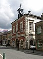
The Old Town Hall is a building on Church Street in the market town of Poulton-le-Fylde in Lancashire, England. The building, which is located just beyond the northern end of Market Place, started life as a public house before becoming a municipal building and then reverting to use as a public house.

The Royal Oak Hotel was a public house and hotel in the market town of Poulton-le-Fylde, Lancashire. It stood on Breck Road at its junction with Station Road. Built in 1842, it was, up until its demolition, the only hotel in the town. It replaced an earlier building, known as the Old Oak, which had also been a dye works.
Queen's Square is a formerly open area in the centre of the English market town of Poulton-le-Fylde, Lancashire. It stands today, immediately to the southeast of Market Place, at the convergence of Blackpool Old Road to the west, Chapel Street and Higher Green to the east and Hardhorn Road to the south.
Market Place is a pedestrianised public square in the English market town of Poulton-le-Fylde, Lancashire. Dating to the Middle Ages, it has historically been a site of weekly markets, today taking place on Mondays. It is now mostly used as a shopping precinct, along with the adjacent indoor Teanlowe Centre.

The Thatched House is a public house on Ball Street in the English market town of Poulton-le-Fylde, Lancashire. A former coaching inn, it stands adjacent to the churchyard of St Chad's, at the corner of Chapel Street. A tavern, believed to have been called the Green Man, was on the site in 1793, and may have been built in the Middle Ages.

Blackpool Old Road is a prominent street in the market town of Poulton-le-Fylde, Lancashire, England. It runs for about 1.65 miles (2.66 km), from Poulton Road and Garstang Road in the south to Queen's Square and Hardhorn Road to the northeast. It becomes the B5268 when it passes Blackpool Road, which carries the designation to and from that point. Blackpool Old Road was formerly known as Bull Street, named for the public house which stands across from Market Place. The pub was rebuilt in 1963.

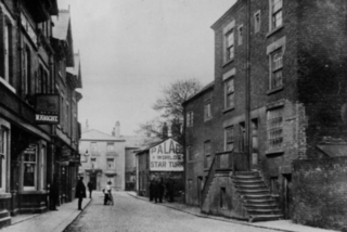
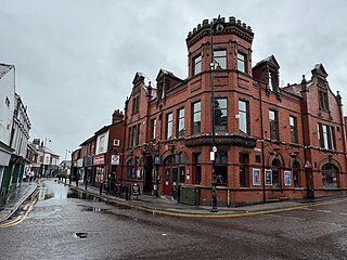
Ball Street is a historic street in the market town of Poulton-le-Fylde, Lancashire, England. It runs for about 300 feet (100 yd), from the junction of Chapel Street, Vicarage Road and Breck Road in the east to its convergence with Tithebarn Street in the west. It is one-way westbound. The street, which is the start or end of today's B5267, has existed since at least the 19th century, which is when the Golden Ball public house was built.

The Bull is a public house on Blackpool Old Road in the English market town of Poulton-le-Fylde, Lancashire. The original pub, named The Black Bull Inn, was built in the 19th century and gave its name to the street on which it stood. Bull Street was renamed Blackpool Old Road in the 20th century. The pub, named the Bull Hotel, was rebuilt in 1963.
Church Street is a historic street in the market town of Poulton-le-Fylde, Lancashire, England. It runs for about 210 feet, from Ball Street in the north to Market Place in the south. An entrance to the Teanlowe Centre shopping precinct is located where Church Street merges into Market Place. The street was pedestrianised in 1983.
Breck Road is a road in Poulton-le-Fylde, Lancashire, England. Originally known as Breck Street, it runs for about 0.79 miles (1.27 km) from Chapel Street, Ball Street and Vicarage Road in the south to Amounderness Way in the north.

The Teanlowe Centre is a shopping centre in Poulton-le-Fylde, Lancashire, England. Completed in 1974, it is bounded by Tithebarn Street to the north, Church Street to the east, Blackpool Old Road to the south and Queensway to the west.


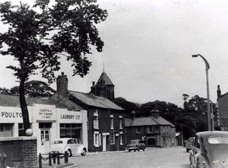
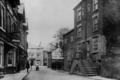 Church Street in the early 1900s. The Golden Ball, using its original entrance, is in view on Ball Street
 Rear (2024)
 Bull tethering rings in the car park
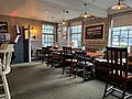 Part of the pub's interior. The windows look onto Ball Street